
Malaysia Federal Route 55
 | |
|---|---|
| Jalan Kuala Kubu Bharu–Teranum–Raub Jalan Pahang (Kuala Kubu Bharu) | |
| Route information | |
| Length | 62 km (39 mi) |
| Existed | 1887[1]–present |
| Major junctions | |
| West end | Kuala Kubu Bharu, Selangor |
| East end | Teranum, Raub District, Pahang |
| Location | |
| Country | Malaysia |
| Primary destinations | Kuala Kubu Bharu Peretak Fraser's Hill Teranum Teras Raub |
| Highway system | |
Federal Route 55 or Jalan Kuala Kubu Bharu–Teranum–Raub (also called Jalan Pahang in Kuala Kubu Bharu) is a 62-km federal road connecting the states of Selangor and Pahang in Malaysia. It is the first federal road ever constructed in Pahang.[1] The road connects Kuala Kubu Bharu, Selangor to Teranum near Raub in Pahang where it meets Federal Route 218. It is the main access route to Fraser's Hill.[2]
Route background[edit]
The Kilometre Zero of the Federal Route 55 is located at Kuala Kubu Bharu, Selangor, at its intersection with the Federal Route 1, the main trunk road of the central of Peninsular Malaysia. After passing Kuala Kubu Bharu town centre, it runs along the eastern circumference of the Selangor Dam. Shortly after passing the Selangor Dam, the road becomes winding as it ascends the Titiwangsa Range until its intersection with the uphill road to Fraser's Hill at The Gap on the Selangor–Pahang state border.
Then, the road descends downhill, running in parallel with the Teranum River until Teranum where it intersects with Malaysia Federal Route 218.[3]
As the road winds through mountainous terrain, it is often prone to landslides which result in partial or total closures of the section between Kuala Kubu Bharu and Teranum.
History[edit]
First East-West Road[edit]
Built in the 1887, Federal Route 55 is the earliest federal road to be constructed in Pahang and the first road over the Titiwangsa Range or Main Range through the pass at The Gap, linking the West Coast of Peninsula Malaysia with the East Coast. It was constructed as an 80-mile bridle track from Kuala Kubu Bharu to Kuala Lipis known as the Kuala Kubu–Kuala Lipis Road. In 1915, a road was constructed from Teranum to Bentong, forming the southern pioneer route for the Federal Route 8.
In 1919, work started on the access road to the hill station from The Gap and by 1922, the hill station named Fraser's Hill was opened to visitors. The road is now designated as Federal Route 56.
The entire roadway was upgraded and paved in 1928 with the specific cost of RM2,004 per mile (or RM1,237 per kilometre), which was considered as the most expensive road project at that time.[1]
During the Malayan Emergency, Sir Henry Gurney, a British High Commissioner in Malaya, was assassinated by the Malayan Communist Party terrorists at Mile 56 ½, Kuala Kubu Road on 7 October 1951, on his way to Fraser's Hill.[4] The communist terrorists ambushed his Rolls-Royce Silver Wraith and shot him to death. His remains were buried at the Cheras Road Christian Cemetery (now Cheras War Cemetery) at Jalan Cheras, Kuala Lumpur.[4][5] A memorial signboard was later erected by Malaysian Public Works Department at the site of the incident (location: 3.673596,101.747346 ).[6]
The portion of the Kuala Kubu–Kuala Lipis Road from Teranum to Raub, together with the road from Teranum to Bentong, became part of Federal Route 8 before they were bypassed by a new, straighter super two road through FELDA Lurah Bilut.[7] There after, the bypassed old road between Bentong and Raub including the section between Teranum and Raub was re-gazetted to become the new Federal Route 218.[8]
At the end of the 1990s, a new water dam known as the Sungai Selangor Dam was constructed to cater to the increasing water demand in the Klang Valley. During construction, a 7.7-km super two road was built to replace the existing roadway at the Sungai Selangor Dam construction site. Construction started in 2001 and was completed in 2003. This road has two bridges, the Sungai Selangor bridge and the Sungai Peretak bridge.[9]
List of junctions and towns[edit]
This article contains a bulleted list or table of intersections which should be presented in a properly formatted junction table. (November 2021) |
| km | Exit | Junctions | To | Remarks | |
|---|---|---|---|---|---|
0 |
Kuala Kubu Bharu Kuala Kubu Bharu-Federal Route 1 Junction |
North Tanjung Malim Slim River Ipoh Universiti Pendidikan Sultan Idris (UPSI) Sabak Bernam via Tanjung Malim Interchange for West Jalan Stesen Keretapi Kuala Kubu Bharu railway station South Rasa Batang Kali Rawang Kuala Lumpur |
Signalised crossroads | ||
| Malaysian Road Transport Department (JPJ) district branch office | |||||
| Kuala Kubu Bharu Taman Teratai Taman Arif |
North Taman Teratai Taman Arif |
T-junction | |||
| Kuala Kubu Bharu Kampung Kelapa |
South Kampung Kelapa |
T-junction | |||
| Kuala Kubu Bharu Jalan Tun Salleh Ismail |
North Jalan Tun Salleh Ismail |
T-junction | |||
| Sungai Kubu bridge | |||||
| Kuala Kubu Bharu Jalan Syed Masyor |
North Jalan Syed Masyor Hospital Kuala Kubu Bharu Perpustakaan Syed Masahor (Hulu Selangor District Library) |
T-junction | |||
| Masjid Jamek Al-Rahimiah | |||||
| Stadium Mini Kuala Kubu Bharu | |||||
| Majlis Daerah Hulu Selangor (MDHS) headquarters | Majlis Daerah Hulu Selangor (MDHS) headquarters Monument of Kuala Kubu Tragedy |
||||
| Kuala Kubu Bharu Jalan Merdeka |
North Jalan Merdeka Town Centre Kuala Kubu Bharu Post Office |
T-junction | |||
| Kuala Kubu Bharu Jalan Ampang Pechah |
North Jalan Bukit Kerajaan Government offices Hulu Selangor District and Land Offices Kuala Kubu Bharu Magistrate Court South Ampang Pechah (Site of the original Kuala Kubu) Rasa Kuala Lumpur Darul Quran Jakim |
Signalised crossroads | |||
| Hindu Temple | |||||
| Kuala Kubu Bharu Jalan Kubu |
North Jalan Kubu Town Centre Hulu Selangor District Police Headquarters |
T-junction | |||
| Malaysian Public Works Department (JKR) Hulu Selangor District Headquarters | |||||
| Sungai Kubu bridge | |||||
| Kampung Asam Kumbang Jalan Tengah |
North Jalan Tengah Kampung Asam Kumbang (Kuala Kubu Bharu New Village) |
T-junction | |||
| Taman Bukit Bunga | North Taman Bukit Bunga |
T-junction | |||
| Kuala Kubu Bharu Ranger Office | |||||
| Sungai Kelempung bridge | |||||
| Taman Selesa | North Taman Selesa |
||||
| Start/end of narrow roads | |||||
| Kampung Gerachi | North Jalan Baru Kampung Gerachi Kampung Gerachi |
T-junction | |||
| Sungai Selangor bridge | |||||
| Start/end of dual carriageway | |||||
| Sungai Selangor Dam | Sungai Selangor Dam North Splash visitor centre |
T-junction | |||
| Start/end of dual carriageway | |||||
| Sungai Peretak bridge | |||||
| Kampung Peretak | East Jalan Baru Kampung Peretak Kampung Peretak |
T-junction | |||
| Start/end of narrow roads | |||||
| Sungai Chilling bridge | Old bridge Historical site | ||||
| Sungai Chilling waterfalls |
Sungai Chilling waterfalls Sungai Chilling Fish Sanctuary |
||||
| Sungai Gumut waterfalls |
Sungai Gumut waterfalls Sungai Chilling Fish Sanctuary |
||||
| Sungai Gumut bridge | |||||
| Sir Henry Gurney's murder site | Sir Henry Gurney's murder site |
Historical site during Malayan Emergency (1948-1960) not marked | |||
| The Gap Public Toilet | Dismantled | ||||
| The Gap Pedestrian Suspension Bridge | Abandoned | ||||
| The Gap Rest House | Abandoned | ||||
| The Gap Pedestrian Suspension Bridge | Abandoned | ||||
| The Gap "Welcome to Selangor" Arch | |||||
| The Gap Fraser's Hill Junction |
North Fraser's Hill |
Fraser's Hill-bound only T-junction | |||
| Selangor Darul Ehsan Hulu Selangor district border | |||||
| Pahang-Selangor border * | |||||
| Pahang Darul Makmur Raub district border | |||||
| The Gap Layby | |||||
| The Gap Fraser's Hill Downhill Road Junction |
North |
Exit only No entry T-junction | |||
| Sungai Teranum bridge | |||||
| Sungai Teranum bridge | |||||
| Kampung Sungai Terong Manis | |||||
| Teranum Police Station | East Access Road |
T-junction | |||
| Teranum Old Bentong-Raub Road junction |
North Teras Raub via Kuala Lipis via Kota Bharu via Bentong via East Kampung Sungai Chetang Sang Lee Kampung Sungai Penjuring Bentong via Bentong East Interchange via |
T-junction | |||
* Note: The Pahang-Selangor border runs along the Titiwangsa drainage divide to the east of the archway then proceeds along the middle of the road before proceeding up the hill slope from the point between sentry hut and the road to Teranum at The Gap-Fraser's Hill Road junction.
Gallery[edit]
-
 Selangor River Dam on Route 55.
 -
 Cyclist on the Selangor Dam bridge near Peretak.
 -
 Old Sungai Chiling bridge near Peretak, now replaced with a newer bridge next to it.
 -
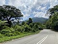 Approaching The Gap on Route 55.
 -
 Route 55 at The Gap, with the road to Fraser's Hill to the left.
 -
 Entering Selangor at The Gap.
 -
 Downhill from The Gap towards Teranum.
 -
 Eastern starting point of Route 55 at intersection with Route 218 at Teranum.
 -
 Eastern starting point of Roue 55 at Teranum.
 -
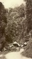 Route 55 circa 1910.


.jpg)


References[edit]
- ^ a b c Roads in Malaysia. Kuala Lumpur: Malaysian Ministry of Works. 2011. p. 16. ISBN 978-967-5399-17-6.
- ^ "Statistik Jalan (Edisi 2013)". Statistik Jalan. Kuala Lumpur: Malaysian Public Works Department: 16–64. 2013. ISSN 1985-9619.
- ^ Inventori Rangkaian Jalan Utama Persekutuan Semenanjung Malaysia. Kuala Lumpur: Malaysian Ministry of Works. 2009. ISBN 978-983-44278-2-5.
- ^ a b "Pembunuhan Sir Henry Gurney". Hari Ini Dalam Sejarah (in Malay). National Archives of Malaysia. 1951-10-07. Archived from the original on 2015-11-17. Retrieved 2015-09-02.
- ^ Slain British Officer Bured
- ^ "Memartabatkan jalan raya melalui tugu peringatan". Blog Jalan Raya Malaysia. 2015-01-26. Retrieved 2015-09-02.
- ^ "Blog Jalan Raya Malaysia @ Cameron Highlands 2013 Part 1: Jalan Persekutuan 8 (Bentong-Raub)". 2013-06-27. Retrieved 2015-08-10.
- ^ Inventori Rangkaian Jalan Utama Persekutuan Semenanjung Malaysia. Kuala Lumpur: Malaysian Ministry of Works. 2009. pp. 470–471. ISBN 978-983-44278-2-5.
- ^ Mokhtar Jaafar; et al. "Indeks Kualiti Air (IKA) Sg. Selangor pasca pembinaan Empangan Sg. Selangor" (PDF). Geografia - Malaysian Journal of Society and Space (in Malay) (3): 68–75. Retrieved 1 September 2015.