
Mount Alford, Queensland
| Mount Alford Queensland | |||||||||||||||
|---|---|---|---|---|---|---|---|---|---|---|---|---|---|---|---|
 Paddocks to the north east of Mount Moon | |||||||||||||||
| Population | 344 (2011 census)[1] | ||||||||||||||
| Postcode(s) | 4310 | ||||||||||||||
| Elevation | 120 m (394 ft) | ||||||||||||||
| LGA(s) | Scenic Rim Region | ||||||||||||||
| State electorate(s) | Beaudesert | ||||||||||||||
| Federal division(s) | Wright | ||||||||||||||
| |||||||||||||||
Mount Alford is a locality and town in the Scenic Rim Region of South East Queensland, Australia.[2][3] At the 2011 Australian Census Mount Alford and the adjacent locality of Bunjurgen recorded a population of 344.[1]
Geography
Teviot Brook passes just to the east of the town. Downstream is the Wyaralong Dam. Erosion along Blackrock Creek has prompted the Scenic Rim Regional Council and SEQ Catchments to implement on-farm infrastructure and land management practice changes to reduce sediment runoff and improve water quality.[4] In the south west of the locality the land slopes upwards towards Mount Moon.
History
Mount Alford was previously known as Reckumpilla.[5] It was renamed after Thomas Alford who managed Coochin Coochin station from 1868 onwards. A general store opened in the town in c1888 by August Anders. The building was rebuilt in 1913 upon sale by the Anders family.[6] Mount Alford Primary school was built in 1888.[7] A monument to those who served and who were killed in World War I was erected in 1918.[5]
Heritage listings
Mount Alford has the following heritage-listed sites:
- 889 Reckumpilla Street: Mount Alford School of Arts [6]
- 898 Reckumpilla Street: Mount Alford General Store [6]
Gallery
-
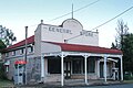 Mount Alford General Store
 -
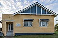 Mount Alford School of Arts established 1906


References
- ^ a b Australian Bureau of Statistics (31 October 2012). "Mount Alford (State Suburb)". 2011 Census QuickStats. Retrieved 1 September 2014.
- ^ "Mount Alford (entry 46153)". Queensland Place Names. Queensland Government. Retrieved 1 September 2014.
- ^ "Mount Alford (entry 22965)". Queensland Place Names. Queensland Government. Retrieved 1 September 2014.
- ^ "Making a difference to Teviot Brook: Verena and Todd Joyce's creek project". SEQ Catchments. Retrieved 1 September 2014.
- ^ a b Environmental Protection Agency (Queensland) (2000). Heritage Trails of the Great South East. State of Queensland. p. 33. ISBN 0-7345-1008-X.
- ^ a b c "Local Heritage Register" (PDF). Scenic Rim Regional Council. Retrieved 9 February 2015.
- ^ "History". Department of Education, Training and Employment. Retrieved 1 September 2014.
External links
![]() Media related to Mount Alford, Queensland at Wikimedia Commons
Media related to Mount Alford, Queensland at Wikimedia Commons
This Queensland location article is a stub. You can help Wikipedia by expanding it. |