
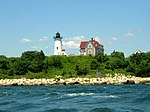
Nobska Light
 Nobska Light in 2016 | |
 | |
| Location | Woods Hole, Massachusetts |
|---|---|
| Coordinates | 41°30′56.7″N 70°39′18.5″W / 41.515750°N 70.655139°W |
| Tower | |
| Constructed | 1829 |
| Foundation | Natural Emplaced |
| Construction | Iron with brick lining |
| Automated | 1985 |
| Height | 40 feet (12 m) |
| Shape | Cylindrical |
| Markings | White with black lantern |
| Heritage | National Register of Historic Places listed place |
| Fog signal | 2 blasts every 30s |
| Light | |
| First lit | 1876 (current tower) |
| Focal height | 87 feet (27 m) |
| Lens | Fifth-order Fresnel lens, 1876 |
| Range | White 13 nautical miles (24 km; 15 mi), Red 11 nautical miles (20 km; 13 mi) |
| Characteristic | Fl W, 6 sec. Red sector |
Nobska Light, or Nobsque Light, also known as Nobska Point Light is a lighthouse located at the division between Buzzards Bay and Vineyard Sound in Woods Hole, Massachusetts on the southwestern tip of Cape Cod, Massachusetts. It overlooks Martha's Vineyard and Nonamesset Island. The light station was established in 1826, and the current tower dates to 1876. The light station was added to the National Register of Historic Places as Nobska Point Light Station in 1987.
Description and history
Nobska Light is set at the very southwestern tip of Cape Cod, separated from the shore by Nobska Road. The light station includes four buildings: the tower, the keeper's house, a radio beacon house, and a small oil house. The tower has a brick interior and a metal exterior, formed out of four rings of iron paneling, and rises to a height of 40 feet (12 m). The first three panels each have a single sash window with an Italianate surround, while the fourth level sports four porthole windows. The tower is topped by a ten-sided lantern house with an iron balcony and railing encircling it. A wood frame entry vestibule with gable roof projects toward the keeper's house. The oil house is a small brick structure with a gable roof, while the radio beacon house is a larger brick structure, also with a gable roof.[5]
The light station was established in 1828, with the original light mounted on top of the keeper's house. In 1876 the present tower was built, along with one portion of the keeper's house and the oil house. The keeper's house was built in two stages, and was built to house both a keeper and an assistant. It is a 1-1/2 story Cape style wood frame house, whose older section was built in 1876; the other half was built in 1905. A central single-story cross-gable wing extends toward the tower, with enclosed porches on either side.[5] In 1939 the United States Coast Guard replaced the U.S. Lighthouse Service as the agency responsible for maintaining the light. In 1972 active duty Coast Guard replaced the civilian lighthouse keeper. In 1948 a steel radio tower and fog station were added. In 1985 the lighthouse was automated and the house converted to the residence for the Commanding Officer of United States Coast Guard Sector Southeastern New England. It was listed on the National Register of Historic Places in 1987.[4] In 2012, the house was deemed in need of serious maintenance and was discontinued as a residence.
In 2015, the Coast Guard decided to deaccession the lighthouse and opened it to bid to municipalities, non-profits or, lacking either of these, for private sale. Four organizations in Falmouth concerned with historic preservation banded together under the aegis of the Town of Falmouth to form a new non-profit to bid for the license for the lighthouse and its 2.3 acres site. The Town of Falmouth's application was accepted by the Coast Guard in September of 2015 and the parties entered into a licensing process that is anticipated to be completed early in 2016. The Town's plan is to hand over renovation and maintenance to the non-profit created for this purpose, the Friends of Nobska Light, which, when the restoration is complete, will operate the lighthouse as a museum open to the public for free. Nobska will then join the 100+ lighthouses in the country that have passed from federal to local and private management since global positioning systems and other improvement to navigation reduced the need for manned lighthouses.
Gallery
-
-
 History of Nobska Point
 -
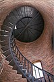 Brick lined interior & spiral stairway
 -
 Fourth-Order Fresnel Lens at Nobska
 -
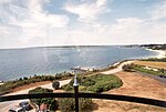 Vineyard Sound viewed through glass enclosure at Nobska Light
 -
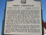
 Signage at Nobska
 -

-
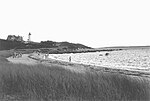 Local beach near Nobska Point, Woods Hole


See also
- Cape Neddick Light, a similar lighthouse in Maine, constructed in 1879.
- National Register of Historic Places listings in Barnstable County, Massachusetts
References
- ^ "Historic Light Station Information and Photography: Massachusetts". United States Coast Guard Historian's Office. Archived from the original on 2017-05-01.
- ^ Light List, Volume I, Atlantic Coast, St. Croix River, Maine to Shrewsbury River, New Jersey (PDF). Light List. United States Coast Guard. 2012. p. 145.
- ^ Rowlett, Russ (2012-02-24). "Lighthouses of the United States: Southeast Massachusetts". The Lighthouse Directory. University of North Carolina at Chapel Hill.
- ^ a b "National Register Information System". National Register of Historic Places. National Park Service. July 9, 2010.
- ^ a b "MACRIS inventory record and NRHP nomination for Nobska Light Station". Commonwealth of Massachusetts. Retrieved 2015-04-14.
External links

| Topics |  | ||||||||||||||||
|---|---|---|---|---|---|---|---|---|---|---|---|---|---|---|---|---|---|
| Lists by county | |||||||||||||||||
| Lists by city |
| ||||||||||||||||
| Other lists | |||||||||||||||||
- Lighthouses completed in 1829
- Towers completed in 1829
- Lighthouses completed in 1876
- Towers completed in 1876
- Falmouth, Massachusetts
- Lighthouses on the National Register of Historic Places in Massachusetts
- Lighthouses in Barnstable County, Massachusetts
- National Register of Historic Places in Barnstable County, Massachusetts