Octeville-sur-Mer
Appearance
Octeville-sur-Mer | |
|---|---|
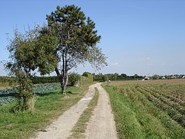
 The plateau between the village and the sea | |
| Coordinates: 49°33′23″N 0°07′04″E / 49.5564°N 0.1178°E | |
| Country | France |
| Region | Normandy |
| Department | Seine-Maritime |
| Arrondissement | Le Havre |
| Canton | Octeville-sur-Mer |
| Intercommunality | CA havraise |
| Area 1 | 20.37 km2 (7.86 sq mi) |
| Population (2006) | 5,525 |
| • Density | 270/km2 (700/sq mi) |
| Time zone | UTC+01:00 (CET) |
| • Summer (DST) | UTC+02:00 (CEST) |
| INSEE/Postal code | 76481 /76930 |
| Elevation | 0–105 m (0–344 ft) (avg. 75 m or 246 ft) |
| 1 French Land Register data, which excludes lakes, ponds, glaciers > 1 km2 (0.386 sq mi or 247 acres) and river estuaries. | |
Octeville-sur-Mer is a commune in the Seine-Maritime department in the Normandy region in northern France and is twinned with Bourne End (Bucks) in United Kingdom since 2003 and with Furci Siculo (Sicily) in Italy since 2010.
Geography
A small farming town in the Pays de Caux with huge cliffs overlooking the English Channel, some 4 miles (6.4 km) north of Le Havre, at the junction of the D31 and D940 roads. The commune covers a large area, and boasts an airport (of Le Havre), a golf course and several small villages and hamlets.
Heraldry
 |
The arms of Octeville-sur-Mer are blazoned : Azure, a chevron fracted argent between 3 escallops Or.
|
Population
| 1962 | 1968 | 1975 | 1982 | 1990 | 1999 | 2006 |
|---|---|---|---|---|---|---|
| 2038 | 2057 | 2334 | 3251 | 4005 | 4834 | 5525 |
| Starting in 1962: Population without duplicates | ||||||
Places of interest

- The church of St.Martin, dating from the thirteenth century.
- The church of St.Barthélemy, dating from the seventeenth century.
- The remains of some World War II artillery defences.
See also
References
External links
Wikimedia Commons has media related to Octeville-sur-Mer.
- Official commune website Template:Fr
- Octeville-sur-Mer on the Quid website Template:Fr
- The Octeville sur Mer twinning association website


