
Oodnadatta Track
Oodnadatta Track | |
|---|---|
 | |
| Oodnadatta Track (depicted in blue) | |
| General information | |
| Type | Track |
| Length | 617 km (383 mi) |
| Major junctions | |
| NW end | Marla |
| SE end | Birdsville Track, Marree |
| Location(s) | |
| Region | Far North[1] |
| Restrictions | |
| Fuel supply | Marla, Oodnadatta, William Creek, Marree |
| Facilities | airstrips, charters at all towns, UHF Radio repeaters with 100 km range on various channels provide emergency contact with locals. Swimming pools and police stations at Oodnadatta and Marla |
The Oodnadatta Track, Australia is an unsealed 617 km (383 mi) outback road between Marree and Marla via Oodnadatta in South Australia.[2] Along the way, the track passes the southern lake of the Kati Thanda-Lake Eyre National Park, and the outback settlements of William Creek and Oodnadatta.[3]
The track follows a traditional Aboriginal trading route. It provides travellers with stunning semi-desert scenery. Along the Track are numerous springs feeding water from the Great Artesian Basin, the most accessible examples being the mound springs found in Wabma Kadarbu Mound Springs Conservation Park near Coward Springs. Later, because of the availability of water, the route was chosen for the steam-train powered Central Australian Railway, the original route of The Ghan, also the route taken by the explorer John McDouall Stuart on his third expedition in 1859.[4] Remnants of the many railway sidings and bridges, the ruins of railway buildings, and Overland Telegraph repeater stations are located along the track – some of the best preserved are the Coward Springs Campground – complete with natural artesian spa and Curdimurka.
Today, the Oodnadatta Track roughly follows the former railway line as far north as Oodnadatta, and then turns to the west, meeting the sealed Stuart Highway at Marla. The road's surface has been well maintained in recent years. In dry weather, the track is passable to most 2 WD vehicles and caravans, but a four-wheel drive (4x4) vehicle will provide a more comfortable journey, and will be essential for driving the track during and after rain. Since the track is unsealed, the Government of South Australia recommends that users of the track check if the track is open before departure.[5]
The Track was named by Adam Plate of the Oodnadatta Progress Association Inc. in about 1980 to form a trilogy of unsealed tourist routes with the Birdsville and Strzelecki Tracks nearby.[citation needed]
Gallery
-
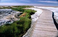 Mound Springs on the Oodnadatta Track.
 -
 Lake Eyre South from Oodnadatta Track


See also
References
- ^ "Far North (South Australian Government Region)" (PDF). The Government of South Australia. Retrieved 19 June 2015.
- ^ Hema, Maps (2007). Australia Road and 4WD Atlas (Map). Eight Mile Plains Queensland: Hema Maps. pp. 72–73. ISBN 978-1-86500-456-3.
{{cite map}}: Cite has empty unknown parameter:|1=(help) - ^ "Oodnadatta Track: Wiliam Creek, Coward Springs & Pink Roadhouse" In Australien. Retrieved 2015-09-10.
- ^ "Outback: The Oodnadatta Track". National Roads and Motorists' Association (NRMA). Retrieved 24 June 2008.
- ^ "Area 3 - Oodnadatta Track including Coober Pedy, Cadney Park, Marla and Mt Dare areas". Department of Planning, Transport and Infrastructure. Retrieved 19 June 2015.
External links
 Oodnadatta Track travel guide from Wikivoyage
- "Tracking History to Oodnadatta" by Roderick Eime
Road infrastructure in South Australia | ||
|---|---|---|
| Expressways |
| |
| Interstate highways | ||
| State highways | ||
| Arterial roads |
| |
| Outback tracks | ||
This Australian road or road transport-related article is a stub. You can help Wikipedia by expanding it. |