From Wikipedia, the free encyclopedia
Pachatusan (Quechua pacha earth, tusa , a prop to support a wall or building, pachatusa prop of the earth, -n a suffix ) is a mountain northeast of the city of Cusco in the Andes of Peru , about 4,842 metres (15,886 ft) high. It is located in the Cusco Region , Calca Province , San Salvador District , in the Cusco Province , in the districts San Jerónimo and Saylla , and in the Quispicanchi Province , Oropesa District . It is situated on the western bank of the Willkanuta River, beside the mountain Waypun in the south-east.[ 2] Señor de Huanca .
By the local people Pachatusan is venerated as an apu .
On February 16, 2009, the cultural archaeological landscape of Pachatusan was declared a National Cultural Heritage by Resolución Directoral Nacional No. 231/INC.[ 3]
Gallery
See also
References
^ conservation.org "Forests for Water in the Sacred Mountain "^ escale.minedu.gob.pe - UGEL map of the Calca Province (Cusco Region)
^ Resolución Directoral Nacional No. 913/INC
Acaray Ahuila Gencha Machay Amaru Marka Wasi Arhuaturo Asana Asiru Phat'jata Aspero Auga Punta Auquilohuagra Awkin Punta Awkimarka (Apurímac) Awkimarka (Huánuco) Aya Muqu Ayamachay Ayawayq'u Azángaro Baths of Boza Bandurria Buena Vista Cahuachi Cajamarquilla Cao Viejo Carachupa Carajía Caral Caves of Sumbay Cerro Baúl Cerro Pátapo Cerro Trinidad Chacamarca Chan Chan Chanquillo Chauchilla Cemetery Chavín de Huantar Chawaytiri Cheqollo Chichakuri Chipaw Marka Choquepuquio Choquequirao Choquequirao Puquio Churajón Chuya Cochabamba Cochapata Colcampata Collor Condorcaga Cota Coca Coricancha Cumbemayo Cutimbo El Brujo El Cañoncillo El Ingenio El Paraíso Garagay Gran Pajatén Gran Vilaya Guellayhuasin Guitarrero Cave Hatun Machay Hatun Misapata Hatun Rumiyoc Hatun Uchku Hatun Usnu Hatunmarka Honcopampa Huaca de la Luna Huaca del Dragón Huaca del Sol Huaca Huallamarca Huaca Prieta Huaca Pucllana Huaca San Marcos Huaca Santa Ana Huacramarca Hualpayunca Huamanmarca, La Convención Huamboy Huankarán Huaycán de Pariachi Huánuco Pampa Huari Huayna Picchu Huayrapongo Huchuy Qosqo Huiñao Inca Uyo Incahuasi, Lima Ingatambo Inka Mach'ay Inka Raqay, Apurímac Inka Raqay, Ayacucho Inka Tampu, Huayopata Inka Tampu, Vilcabamba Inka Tunuwiri Inka Wasi, Ayacucho Inka Wasi, Huancavelica Inkapintay Inkilltambo Inti Punku Inti Watana, Ayacucho Inti Watana, Calca Inti Watana, Urubamba Intikancha Intini Uyu Pata Intipa Ñawin Intiyuq K'uchu Iskuqucha Isog Jinkiori Jisk'a Iru Muqu Kanamarka Kanichi Kenko Killa Mach'ay Killarumiyuq Kotosh Kuelap Kukuli Kuntur Wasi Kunturmarka, Ayacucho Kunturmarka, Pasco Kuntuyuq Kusichaka valley Khichuqaqa Khuchi Mach'ay K'allapayuq Urqu K'ipakhara La Otra Banda Laguna de las Momias Lauricocha Caves Layzón Llactan Llamachayuq Llamachayuq Qaqa Llamayuq Llamuqa Llaqta Qulluy, Acoria Llaqta Qulluy, Conayca Llaqta Qulluy, Tayacaja Llaqta Qulluy, Vilca Llaqtapata Machu Colca Machu Picchu Machu Pirqa Machu Pitumarka Machu Q'inti Mallkuamaya Mameria Maray Qalla Marayniyoq Marcahuamachuco Markahirka Markansaya Markapukyu Marpa Mawk'allaqta, Castilla Mawk'allaqta, Espinar Mawk'allaqta, La Unión Mawk'allaqta, Melgar Mawk'allaqta, Paruro Mawk'allaqta, Sandia Mawk'ataray Mazur Miculla Millka Miraflores Mirq'imarka Miyu Pampa Molloko Moray Mulinuyuq Mullu Q'awa Muyu Muyu Muyu Urqu Muyuq Marka Nazca Lines Nina Kiru Ninamarca Ñawpallaqta, Huanca Sancos Ñawpallaqta, Fajardo Ñawpallaqta, Lucanas Ñusta Hispana Ollantaytambo Pacatnamu Pachacamac Pachatusan Paiján Pañamarca Paracas Candelabra Paraccra Patallaqta Pikillaqta Pikimach'ay Pilluchu Pinkuylluna Pirca Pirca, La Libertad Pirca Pirca, Lima Pirhuaylla Piruro Pirwayuq Písac Puka Pukara Puka Tampu Puka Urqu Pukara, Coporaque Pukara, Fajardo Pukara, Puno Pukara, Vilcas Huamán Pukarani Pumamarka, San Sebastián Pumamarka, Urubamba Pumaq Hirka Pumawasi Punkuri Puqin Kancha Puruchuco Purunllacta, Cheto Purunllacta, Soloco Pusharo Pusuquy Pata Puyupatamarca Qaqapatan Qenko Qillqatani Qillqa Qillqay Mach'ay Quiaca Quillarumi Quishuar Qullqapampa Qulu Qulu Qunchamarka Qunchupata Quri Winchus Qurimarka, Apurímac Qurimarka, Cusco Quriwayrachina, Anta Quriwayrachina, Ayacucho Quriwayrachina, La Convención Qasa Pata Qhapaq Kancha Raqch'i Revash Rumicolca Rumiwasi Runayoc Runkuraqay Sacsayhuamán Sara Sara Sayacmarca Sayhuite Sechín Sillustani Sipán Sóndor Soro Mik'aya Patjxa Susupillu Tambo Totem Tambomachay Tampu Mach'ay, Huancavelica Tampukancha Tanqa Tanqa Tantarica Taqrachullu Tarahuasi Tarmatambo Templo del Zorro The Toads of Wiraqucha Tikra Tinyaq Tipón Titiqaqa Toquepala Caves Toro Muerto Trinchera Túcume Tunanmarca Tunay Q'asa Tupu Inka T'akaq T'uqu T'uquyuq Uchkus Inkañan Urpish Uskallaqta Usnu, Ayacucho Usnu, Huánuco Usnu Muqu Usqunta Uyu Uyu Venado cautivo Ventanillas de Otuzco Ventarron Vilcabamba Vilcashuamán Viracochapampa Vitcos Waman Pirqa Wamanilla Wamanmarka, Chumbivilcas Wamanmarka, Lima Wanakawri, Cusco Wanakawri, Huánuco Waqlamarka Waqra Pukara Waqutu Warahirka Waraqayuq Waraqu Urqu Warawtampu Wari Willka Waruq Wat'a, Cusco Wat'a, Huánuco Wayna Q'inti Wayna Tawqaray Wichama Wichqana Wich'un Wila Wilani Wilca Wilcahuaín Willkaraqay Wiñay Wayna Wiraqucha Pirqa Yanaca Yanaqi - Qillqamarka Yaynu Yuraq Mach'ay


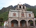 Pachatusan above the sanctuary Señor de Huanca