Pishin District
This article has multiple issues. Please help improve it or discuss these issues on the talk page. (Learn how and when to remove these template messages)
|
Pishin District
ضلع پشین پښين ولسوالۍ پشین دمگ | |
|---|---|
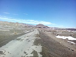
 View of Bala Niganda Village | |
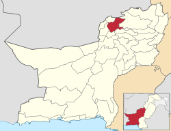
 Map of Balochistan with Pishin District highlighted | |
| Country | |
| Province | |
| Division | Quetta |
| Headquarters | Pishin |
| Government | |
| • Type | District Administration |
| • Deputy Commissioner | Dr. Yasir Khan Bazai |
| • District Police Officer | N/A |
| • District Health Officer | N/A |
| Area | |
| • Total | 6,218 km2 (2,401 sq mi) |
| Elevation | 1,555 m (5,102 ft) |
| Population (2017) | |
| • Total | 736,903 |
| • Density | 120/km2 (310/sq mi) |
| Time zone | UTC+5 (PST) |
| Calling code | 826[1] |
| National Assembly Seats (2018) | Total (1)
|
| Balochistan Assembly Seats (2018) | Total (3)
|
| Number of Tehsils | 2 |
| Website | quetta |
Pishin (Pashto: پښين, Urdu: ضلع پشین), IPA: pʂin/pçin, is a district in the Balochistan province of Pakistan. District Pishin is located at a strategic point and is 45km² from the provincial headquarters. In 1975, it was bifurcated from Quetta District, while in 1993 part of it was split off to form the new district of Killa Abdullah.[2] Again in 2022, part of it created the new district of Karezat. The name Pishin is a modernized form of ‘Pushang’, which is how the city was designated in (mainly pre-modern) Persian sources (Arabic sources using 'Fushang'). Myth attributes the origin of the Persian designation to a son of the mythical Emperor Afrasiab. Fushing was the spelling used in the records of the Afghan government. The population of Pishin District was 300,000 in 2005.[3]
Administration[edit]
- Pishin Tehsil
- Huramzai Tehsil
- Karezat Tehsil
- Saranan Tehsil
- Barshore Tehsil
Demographics[edit]
Population
At the time of the 2017 census, the district had a population of 736,903, of which 380,615 were males and 356,227 females. The rural population was 594,107 (80.62%) while the urban population was 142,796 (19.38%). The literacy rate was 52.97% - the male literacy rate was 69.00% while the female literacy rate was 36.22%. 994 people in the district were from religious minorities.[4]
Ethnic groups
Pishin's main ethnic groups are Pashtuns who belong to the Tareen, Syed, Kakar, and Achakzai tribes. However, the Tareen tribe is known to be the ruling one among them.
Religion
| Religious group |
1941[5]: 13–14 | 2017[6][7] | ||
|---|---|---|---|---|
| Pop. | % | Pop. | % | |
| Islam |
1,245 | 65.87% | 35,067 | 98.65% |
| Hinduism |
447 | 23.65% | 3 | 0.01% |
| Sikhism |
183 | 9.68% | — | — |
| Christianity |
15 | 0.79% | 473 | 1.33% |
| Ahmadiyya |
— | — | 4 | 0.01% |
| Total population | 1,890 | 100% | 35,547 | 100% |
Languages
At the time of the 2017 census, 97.54% of the population spoke Pashto and 1.15% Brahui as their first language.
Agriculture and Farming[edit]
The main crops in the area are wheat, barley, corn (maize), potatoes, grapes, apples, apricots, and peaches which are grown in the valleys. Sheep and goats are also herded.[8]
Notable people[edit]
- Qazi Muhammad Essa, senior leader of the Pakistan Movement and a close associate of Quaid-e-Azam
- Jennifer Musa, Politician and Social worker
- Jehangir Ashraf Qazi, Diplomat, former Pakistani Ambassador to United States
- Qazi Faez Isa, Justice Pakistan Supreme Court
- Sultan Golden, Motorcycle Stuntman
- Sarwar Khan Kakar, Politician
- Haseebullah Khan, Cricketer
- Nazar Hussain ,Cricketer
See also[edit]
References[edit]
- ^ "National Dialing Codes". PTCL. Archived from the original on 9 November 2015. Retrieved 8 February 2022.
- ^ PCO 2000, p. 1.
- ^ "Home - Government of Balochistan". balochistan.gov.pk. Archived from the original on 2016-06-02. Retrieved 2016-05-14.
- ^ "District Wise Results / Tables (Census - 2017)". www.pbscensus.gov.pk. Pakistan Bureau of Statistics.
- ^ "CENSUS OF INDIA, 1941 VOLUME XIV BALUCHISTAN". Retrieved 27 January 2023.
- ^ "Final Results (Census-2017)". Retrieved 27 January 2023.
- ^ "District Wise Results / Tables (Census - 2017) TABLE 9 - POPULATION BY SEX, RELIGION AND RURAL/URBAN" (PDF). Retrieved 27 January 2023.
- ^ "Pishin | Pakistan". Encyclopædia Britannica.
Bibliography[edit]
- 1998 District census report of Pishin. Census publication. Vol. 113. Islamabad: Population Census Organization, Statistics Division, Government of Pakistan. 2000.

