
Protivín
Protivín | |
|---|---|
 Masarykovo Square | |
 Flag  Coat of arms | |
 Protivín Location in the Czech Republic | |
| Coordinates: 49°11′58″N 14°13′2″E / 49.19944°N 14.21722°E | |
| Country | |
| Region | South Bohemian |
| District | Písek |
| First mentioned | 1282 |
| Government | |
| • Mayor | Jaromír Hlaváč |
| Area | |
| • Total | 61.45 km2 (23.73 sq mi) |
| Elevation | 383 m (1,257 ft) |
| Population (2023-01-01)[1] | |
| • Total | 4,801 |
| • Density | 78/km2 (200/sq mi) |
| Time zone | UTC+1 (CET) |
| • Summer (DST) | UTC+2 (CEST) |
| Postal code | 398 11 |
| Website | www |
Protivín (Czech pronunciation: [ˈprocɪviːn]) is a town in Písek District in the South Bohemian Region of the Czech Republic. It has about 4,800 inhabitants.
Administrative parts[edit]
The villages of Chvaletice, Krč, Maletice, Milenovice, Myšenec, Protivín, Selibov, Těšínov and Záboří are administrative parts of Protivín.
Etymology[edit]
The name is derived from the personal name Protiva, meaning "Protiva's (court, castle)".[2]
Geography[edit]
Protivín is located about 12 kilometres (7 mi) south of Písek and 30 km (19 mi) northwest of České Budějovice. Most of the municipal territory lies in the České Budějovice Basin, but the eastern part extends into the Tábor Uplands and includes the highest point of Protivín, a nameless hill with an altitude of 555 metres (1,821 ft). The Blanice River flows through the town. There are several fishponds in the territory.
History[edit]
The first written mention of Protivín is from 1282. It was founded around 1260 as a village and fortress by a ford across the river Blanice.[3]
In the late 19th century, Protivín developed. However, the prosperity ended with the closure of the sugar factory and a wave of emigration, especially to Iowa in the United States, where the settlement named Protivin was founded by immigrants in 1872. However, the population continued to grow, and in 1899, Protivín was promoted to a town.[3]
Demographics[edit]
|
|
| ||||||||||||||||||||||||||||||||||||||||||||||||||||||
| Source: Censuses[4][5] | ||||||||||||||||||||||||||||||||||||||||||||||||||||||||
Economy[edit]

The town is known for the Protivín Brewery, which produces a regional beer label Platan. It was founded in 1598.[3]
Transport[edit]
The I/20 road (part of the European route E49) from České Budějovice to Plzeň and Karlovy Vary passes through the municipal territory.
Protivín is located on the main railway lines Prague–České Budějovice and Brno–Plzeň.[6]
Sights[edit]

There are three churches in the municipal territory. Church of Saint Elizabeth on the town square was built in 1662 in the early Baroque style. Church of Saint Gall in Myšenec is from the end of the 11th century and after several reconstructions it still retains its Gothic character. Church of Saint Wenceslaus in Krč was built in 1352.[3]
A Renaissance castle is located on the town square. It also includes a park with an area of 7.6 hectares (19 acres).[3]
The Crocodile Zoo Protivín was established in 2008 and is unique by breeding of all of Crocodilia species.[7]
Notable people[edit]
- Ottokar Brzoza-Brzezina (1883–1968), Polish brigadier general
- Marta Krásová (1901–1970), operatic singer
- Jiří Kolář (1914–2002), poet, writer, painter and translator
Twin towns – sister cities[edit]
 Blackwood, Wales, United Kingdom
Gallery[edit]
-
 Church of Saint Gall in Myšenec
 -
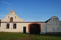 Folk baroque style architecture in Selibov
 -
 Primary school
 -
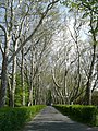 Platanus alley by the brewery

_001.jpg)


References[edit]
- ^ "Population of Municipalities – 1 January 2023". Czech Statistical Office. 2023-05-23.
- ^ Profous, Antonín (1951). Místní jména v Čechách III: M–Ř (in Czech). p. 494.
- ^ a b c d e "Historie města" (in Czech). Město Protivín. Retrieved 2022-08-30.
- ^ "Historický lexikon obcí České republiky 1869–2011 – Okres Písek" (in Czech). Czech Statistical Office. 2015-12-21. pp. 13–14.
- ^ "Population Census 2021: Population by sex". Public Database. Czech Statistical Office. 2021-03-27.
- ^ "Detail stanice Protivín" (in Czech). České dráhy. Retrieved 2024-01-16.
- ^ "O ZOO" (in Czech). Krokodýlí ZOO Protivín. Retrieved 2020-08-22.
- ^ "Home (image No. 4: Twinned Town)". Blackwood Town Council. Retrieved 2023-10-25.
External links[edit]
| International | |
|---|---|
| National | |