
Shimogamo Shrine
| Shimogamo Shrine 下鴨神社 | |
|---|---|
Shimogamo Shrine | |
| Width | 260 |
| Website | |
| http://www.shimogamo-jinja.or.jp/pg150.html | |
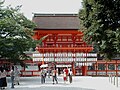
Shimogamo Shrine (下鴨神社, Shimogamo-jinja) in Japanese, is the common name of an important Shinto sanctuary in the Shimogamo district of Kyoto city's Sakyō ward. Its formal name is Kamo-mioya-jinja (賀茂御祖神社).[1] It is one of the oldest Shinto shrines in Japan and is one of the seventeen Historic Monuments of Ancient Kyoto which have been designated by UNESCO as a World Heritage Site. The term Kamo-jinja in Japanese is a general reference to Shimogamo Shrine and Kamigamo Shrine, the traditionally linked Kamo shrines of Kyoto;[2] Shimogamo is the older of the pair, being believed to be 100 years older than Kamigamo, and dating to the 6th century, centuries before Kyoto became the capital of Japan (794, see Heian-kyō). The Kamo-jinja serve the function of protecting Kyoto from malign influences.[3]
The jinja name identifies the Kamo family of kami or deities who are venerated. The name also refers to the ambit of shrine's nearby woods, which are vestiges of the primeval forest of Tadasu no Mori. In addition, the shrine name references the area's early inhabitants, the Kamo clan, many of whom continue to live near the shrine their ancestors traditionally served.[4]
Shimogamo Shrine is dedicated to the veneration of Tamayori-hime (玉依姫; lit., the spirit-inviting maiden) and her father, Kamo Taketsunomi (賀茂建角身). Tamayori-hime is the mother of Kamo Wakeikazuchi (賀茂別雷; the thunder-divider of Kamo), who was sired by Honoikazuchi-no-mikoto (火雷神; the God of Fire and Thunder).[5][6] Kamigamo Shrine, the other of the two Kamo shrines of Kyoto, is dedicated to Kamo Wakeikazuchi. These kami are variously associated with thunder.
History
The shrine became the object of Imperial patronage during the early Heian period.[7]
Shimogamo, along with the Kamigamo Shrine, was designated as one of two chief Shinto shrines (ichinomiya) for the former Yamashiro province.[8]
In 965, Emperor Murakami ordered that Imperial messengers were sent to report important events to Japan's guardian kami, including Kamo-Tamayori-hime and Kamo-Taketsune.[9]
From 1871 through 1946, Shimogamo was officially designated one of the Kanpei-taisha (官幣大社), meaning that it stood in the first rank of government supported shrines.[10]
Imperial visits
- 794 (Enryaku 13): Emperor Kammu came as part of a grand progress.[11]
- 942 (Tengyō 5, 29th day of the 4th month): Emperor Suzaku visited to offer thanks for restoration of peace.[11]
- 979 (Tengen 2, 10th day of the 10th month): Emperor En'yū decided that an Imperial visit Hachiman at Iwashimizu Shrine should be paired with a visit to Kamo.[12]
- 1088 (Kanji 27th day of the 4th month): Emperor Horikawa visited Kamo.[13]
- 1156 (Hōgen 1, 23rd day of the 4th month): Emperor Go-Shirakawa traveled to Kamo.[14]
Structures
A shrine structure was erected in 678 during the reign of the Emperor Tenmu, and this became the principal building during the reign or of the Emperor Kanmu when he removed the capital from Nara to Heian-kyo.[15]
Shimogamo Shrine (Lower Kamo Shrine) is believed to date to the 6th century.
Gallery
-
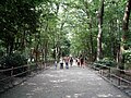 This pathway leads through Tadasu no Mori (the "Forest Where Lies are Revealed").
 -
-
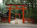 A pair of torii gates, Kawai-jinja
 -
 Mitarai-sha
 -
 Taikobashi bridge


See also
Notes
- ^ Richard, Ponsonby-Fane. (1964) Visiting Famous Shrines in Japan, pp. 1-118.
- ^ Terry, Philip. (1914). Terry's Japanese empire, p. 479.
- ^ Miyazaki, Makoto. "Lens on Japan: Defending Heiankyo from Demons," Daily Yomiuri. December 20, 2005.
- ^ Nelson, John K. (2000). Enduring Identities: The Guise of Shinto in Contemporary Japan, pp. 92-99.
- ^ Kōjien Japanese dictionary, entry for Tamayori-bime.
- ^ Kokugakuin University's digital Encyclopedia of Shinto, entry for Tamayorihime.
- ^ Breen, John et al. (2000). Shinto in History: Ways of the Kami, pp. 74-75.
- ^ "Nationwide List of Ichinomiya," p. 1.; retrieved 2011-08-010
- ^ Ponsonby-Fane. Studies, pp. 116-117.
- ^ Ponsonby-Fane, Richard. (1959). The Imperial House of Japan, pp. 124.
- ^ a b Ponsonby-Fane, Richard. (1964). Visiting Famous Shrines of Japan, p. 47.
- ^ Ponsonby-Fane, Visiting, p. 48.
- ^ Ponsonby-Fane, Visiting, p. 49.
- ^ Ponsonby-Fane, Visiting, p. 50.
- ^ Shimgamo Shrine
References
- Breen, John and Mark Teeuwen. (2000). Shinto in History: Ways of the Kami. Honolulu: University of Hawaii Press. 10-ISBN 0-824-82363-X; 13-ISBN 978-0-8248-2363-4
- Iwao, Seiichi, Teizō Iyanaga, Susumu Ishii, Shōichirō Yoshida, et al. (2002). Dictionnaire historique du Japon. Paris: Maisonneuve & Larose. 10-ISBN 2-7068-1632-5; 13-ISBN 978-2-7068-1632-1; OCLC 51096469
- Nelson, John K. (2000). Enduring Identities: The Guise of Shinto in Contemporary Japan. Honolulu: University of Hawaii Press. 10-ISBN 0-8248-2259-5; 13-ISBN 978-0-8248-2259-0
- Ponsonby-Fane, Richard. (1959). The Imperial House of Japan. Kyoto: Ponsonby Memorial Society. OCLC 194887
- ____________. (1962). Studies in Shinto and Shrines. Kyoto: Ponsonby Memorial Society. OCLC 399449
- ____________. (1964). Visiting Famous Shrines in Japan. Kyoto: Ponsonby-Fane Memorial Society. OCLC 1030156
External links
| Kyoto |  | |
|---|---|---|
| Uji | ||
| Otsu | ||
| ||