Shire of Ravensthorpe
Appearance
| Shire of Ravensthorpe Western Australia | |||||||||||||||
|---|---|---|---|---|---|---|---|---|---|---|---|---|---|---|---|
 Location in Western Australia | |||||||||||||||
| Population | 2,288 (2013 est)[1] | ||||||||||||||
| • Density | 0.16884/km2 (0.43730/sq mi) | ||||||||||||||
| Area | 13,551.1 km2 (5,232.1 sq mi) | ||||||||||||||
| Mayor | Ian Goldfinch | ||||||||||||||
| Council seat | Ravensthorpe | ||||||||||||||
| Region | Goldfields-Esperance | ||||||||||||||
| State electorate(s) | Eyre | ||||||||||||||
| Federal division(s) | O'Connor | ||||||||||||||
| Website | Shire of Ravensthorpe | ||||||||||||||
| |||||||||||||||
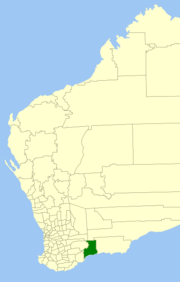
The Shire of Ravensthorpe is a local government area in the southern Goldfields-Esperance region of Western Australia, about halfway between the city of Albany and the town of Esperance and about 530 kilometres (329 mi) southeast of the state capital, Perth. The Shire covers an area of 13,551 square kilometres (5,232 sq mi), and its seat of government is the town of Ravensthorpe.
History
The Phillips River Road District was gazetted in 1900. On 1 July 1961, it changed name to Ravensthorpe and became a shire under the Local Government Act 1960.[2]
Wards
As of the 2003 election, the Shire is divided into three wards:
- Ravensthorpe Ward (two councillors)
- Hopetoun Ward (two councillors)
- Rural Ward (three councillors)
Towns and localities
References
- ^ "3218.0 Regional Population Growth, Australia. Table 5. Estimated Resident Population, Local Government Areas, Western Australia". 3 April 2014. Retrieved 11 September 2014.
- ^ WA Electoral Commission, Municipality Boundary Amendments Register (release 3.0), 31 May 2007.
