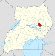
Soroti
Soroti | |
|---|---|
 Soroti Main Street | |
| Country | |
| Region | Eastern Uganda |
| Sub-region | Teso sub-region |
| District | Soroti District |
| Elevation | 3,540 ft (1,080 m) |
| Population (2011 Estimate) | |
• Total | 66,000 |

Soroti is the main municipal, commercial and administrative centre of Soroti District in Eastern Uganda, lying near Lake Kyoga. It is known for the rock formation near the town as well as a variety of Muslim mosques, Hindu temples, Sikh gurdwaras as well as several churches that meet in various buildings in the town varying from the drab Anglican Cathedral to small Pentecostal congregations in school classrooms.
Location
Soroti is located approximately 112 kilometres (70 mi), by road, northwest of the city of Mbale, on the highway between Mbale and Lira.[1] The coordinates of Soroti town are:Latitude:01.7150; Longitude:33.6110.
Overview
The town of Soroti still has many buildings reflecting the tastes of the large Indian population that once traded in the town. These ornate buildings fell into disrepair following Idi Amin’s expulsion of the Asians in the 1970s. In recent years, with the return of stability to the area, the town is beginning to thrive again with many new businesses opening up. This has also increased the sprawl of the town into the surrounding farmland. Soroti market suffered a fire in the late 1990s mainly due to its ramshackle set-up. The market that replaced is much more ordered, but still has stalls of fresh fruit and vegetables, dry goods and the local fish.
It is possible to climb the rock beside the town, with permission from the Town Clerk, and this gives an excellent panorama of the town and the surrounding areas. Views from the rock on a clear day extend as far as Mount Elgon and Lake Kyoga. The rock itself is a volcanic plug, which are common in the region.
At the back of the rock you can still find the graves from Uganda's colonial period. The age at which the residents of these plots died is an indication of the dangers that the area of Soroti once posed. Many of the graves are in disrepair and overgrown. On the otherside of the airport is a much larger municipal cemetery where there are many graves with Arabic inscriptions. Located there is a bath house specifically for the washing of bodies, an important ritual in both local and Islamic burials.
Soroti Airport
Soroti Airport has the third longest tarmac runway in Uganda, at 6,100 feet (1,900 m). The longest paved runway in Uganda, measuring 12,000 feet (3,700 m), is found at Entebbe. The second longest paved runway in Uganda, which measures 10,200 feet (3,100 m), is located at Gulu Airport.[2]
Soroti Airport is capable of handling jets the size of Boeing 737s. Soroti Airport was originally built as a training school for the British Overseas Airways Corporation to train their pilots in tropical flying techniques. It was later used by the East African Flying Academy to train pilots from the East African Community (Uganda, Kenya and Tanzania). Today, the airport is home Soroti Flying School, which has various aircraft, including a Cessna 310.
Security
In the summer of 2003 Soroti was attacked by soldiers from the Lord's Resistance Army. Previous attacks in Uganda had been centred on districts in Northern Uganda. The attack on Soroti was seen by the Ugandan government as an escalation in the threat posed by the LRA because of Soroti airport's strategic military importance. Fierce gun battles between the LRA and government troops forced the LRA back into the surrounding countryside. The threat of abduction posed by LRA soldiers then began a nightly exodus of people from the rural areas into the town seeking protection from the government troops stationed there.
Population
The 2002 national population census estimated the population of Soroti at about 41,700.[3] In 2008, the Uganda Bureau of Statistics (UBOS), estimated the population of Soroti at 56,400.[4] In 2011, UBOS estimated the mid-year population of Soroti at 66,000.[5]
Landmarks
These are some of the landmarks in Soroti:[6]
- The headquarters of Soroti District Administration
- The offices of Soroti Town Council
- A branch of Barclays Bank
- A branch of Centenary Bank
- A branch of Crane Bank
- A branch of PostBank Uganda
- A branch of Stanbic Bank (Uganda) Limited
- A branch of Pride Microfinance Limited - A Tier III Financial Institution
- A branch of Uganda Finance Trust Limited - A Tier III Financial Institution
- A branch of opportunity Bank(Uganda)
- A branch of the National Social Security Fund
- Soroti Regional Referral Hospital - A 275-bed public hospital administered by the Uganda Ministry of Health
- Lwala Soroti Hospital - A 135-bed, Non-Governmental Hospital, administered by the Uganda Catholic Medical Bureau.
- Soroti Airport - Paved runway measures 6,100 feet (1,900 m)
- Soroti Rock - A volcanic rock formation, similar to Tororo Rock
- Soroti Central Market
- Soroti Railway Station - Currently non-functional due to railway system being down in northeastern Uganda.
- Soroti Flying School - Located at the Soroti Airport
- The Soroti Campus of Kumi University, whose main campus is located in Kumi in Kumi District.
- The Soroti Campus of Uganda Martyrs University.
- The headquarters of the Roman Catholic Diocese of Soroti.
- The Mbale-Lira Highway - The road passes through the center of town in a Northwest to Southeast direction
- Voice Of Teso radio 88.4 Fm being the first radio in Teso and the Eastern side of the Nile ever since 1998.

