
Toghrol Tower
35°36′2.37″N 51°26′44.32″E / 35.6006583°N 51.4456444°E
| Tuğrul Tower | |
|---|---|
 View of the Tower from North. | |
| Religion | |
| Affiliation | Islam |
| Ecclesiastical or organizational status | in ruins |
| Location | |
| Location | |
| Specifications | |
| Length | 11 m |
| Width | 16 m |
| Height (max) | 20 m |
| Dome height (outer) | 20+ m |
Tuğrul Tower (also transliterated Toghrul, Tughrol, or Tughrul) is a 12th-century monument, located in the city of Rey, Iran. Tuğrul Tower is near Rashkan Castle.
The 20 meters tall brick tower is the tomb of Seljuk ruler Tuğrul Beg, who died in Rey in 1063. Originally, like other monuments of its time, it was capped by a conical dome (گنبد, gonbad), which would have added to its height. The dome collapsed during an earthquake.
The thickness of the walls varies from 1.75 to 2.75 meters. The inner and outer diameters are 11 and 16 meters, respectively. The exterior shape is that of a polygon with 24 angles in its design, which is thought to contribute to the structure's stability against tremors.
At the top of the tower Kufic inscriptions were originally observable. Naser al-Din Shah ordered some restorations to be made to the top part of the tower, which was collapsing in 1884.
The tower is protected by Iran's Cultural Heritage Organization.
Gallery
-
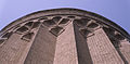 Detail of brickwork of upper sections. The Seljuki style is readily observable.
 -
 Portal and interior.
 -
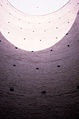 View of interior, which was originally domed with a conical cap.
 -
 Even today without the dome, the precise acoustic properties of the interior are striking.
 -

-


See also
External links
This Iran-related article is a stub. You can help Wikipedia by expanding it. |
