
Civic railway station
Civic | ||||||||||||||||
|---|---|---|---|---|---|---|---|---|---|---|---|---|---|---|---|---|
 | ||||||||||||||||
| General information | ||||||||||||||||
| Location | Hunter Street, Newcastle Australia | |||||||||||||||
| Coordinates | 32°55′36″S 151°46′20″E / 32.926572°S 151.772175°E | |||||||||||||||
| Elevation | 1.2 metres (3.9 ft)[1] | |||||||||||||||
| Owned by | RailCorp | |||||||||||||||
| Operated by | NSW TrainLink | |||||||||||||||
| Line(s) | Central Coast & Newcastle Hunter | |||||||||||||||
| Distance | 167.02 km (103.78 mi) from Central[1] | |||||||||||||||
| Platforms | 2 side | |||||||||||||||
| Tracks | 2 | |||||||||||||||
| Connections | Bus | |||||||||||||||
| Construction | ||||||||||||||||
| Structure type | Ground | |||||||||||||||
| Accessible | Yes | |||||||||||||||
| Other information | ||||||||||||||||
| Station code | CVI | |||||||||||||||
| Fare zone | MyZone 3 | |||||||||||||||
| Website | Civic | |||||||||||||||
| History | ||||||||||||||||
| Opened | 1857, 1935 (reopened) | |||||||||||||||
| Closed | 1872, | |||||||||||||||
| Electrified | Yes | |||||||||||||||
| Services | ||||||||||||||||
| ||||||||||||||||
Civic railway station opened on 30 March 1857 as Newcastle railway station. On 9 March 1858 it was renamed Honeysuckle and again on 1 September 1866 to Honeysuckle Point. The station closed in 1872 only to be reopened as its current name of Civic on 22 December 1935.[1] Civic station is located in Newcastle, Australia on the Central Coast & Newcastle, and Hunter lines. The station is a side station with two platforms. Civic is served by trains to Newcastle, Sydney, Maitland, Muswellbrook, Scone, Telarah and Dungog.
In December 2012 the Government of New South Wales announced the line east of Wickham will close sometime after 2015.[2] This will result in the closure of Civic.
Platforms and services
The station has platforms six carriages long, passengers on longer trains are required to use the rear six carriages.
To reduce delays to road traffic at the adjacent level crossing, the Newcastle bound platform was lengthened and the signal protecting the level crossing was relocated.[3] Previously, the level crossing remained closed from when a train approached the platform, for the whole time that the train was stopped and until the train cleared the level crossing. As a result of this platform modification, the level crossing does not close until the train is ready to depart from the platform.
| Platform | Line | Stopping pattern | Notes |
| 1 | intercity electric services to Newcastle | ||
|---|---|---|---|
| diesel rail-car services to Newcastle | |||
| 2 | intercity electric services to Gosford, Hornsby & Sydney Central | ||
| diesel rail-car services to Maitland, Telarah, Dungog, Muswellbrook & Scone |
Gallery
-
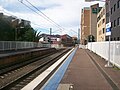
 Platforms
 -
 Footbridge
 -
 East end of platforms
 -
 Entrance on platform 2 side
 -
 Looking east from footbridge
 -
 Looking west from footbridge
 -
 Up platform extension
 -
 Station facade from road
 -
 Entrance to platform 1 and the stairs to footbridge
 -
 Looking down the footbridge stairs to exit
 -
 Platforms seen from railway crossing
 -
 Next train service destination indicator on platform 1


References
- ^ a b c Station Names. Date of opening, closing and/or change of name. Public Transport Commission of New South Wales Administrative Branch (Archives Section) (3rd ed.). February 1979. p. 8.
{{cite book}}: CS1 maint: others (link) - ^ The deepest cut...Newcastle's rail line to go ABC News 14 December 2012
- ^ Newcastle Rail Corridor Project Upgrades (PDF), NSW Government, p. 2, retrieved 26 November 2006
{{citation}}: Italic or bold markup not allowed in:|publisher=(help)