
Irrawaddy River
The Irrawaddy River or Ayeyarwady River(Burmese: ဧရာဝတီမြစ်; MLCTS: erawa.ti mrac,pronounced [ʔèjàwədì mjɪʔ], also spelt Ayeyarwaddy) is a river that flows from north to south through Burma (Myanmar). It is the country's largest river and most important commercial waterway. Originating from the confluence of the N'mai and Mali rivers, it flows relatively straight North-South before emptying through the Irrawaddy Delta into the Andaman Sea. Its drainage area of about 413,000 km² covers a large part of Burma. After Rudyard Kipling's poem, it is sometimes referred to as 'The Road to Mandalay'.
As early as the sixth century the river was used for trade and transport. Having developed an extensive network of irrigation canals, the river became important to the British Empire after it had colonized Burma. The river is still as vital today, as a considerable amount of (export)goods and traffic moves by river. Rice is produced in the Irrawaddy Delta, irrigated by water from the river.
In 2007, Burma's military government signed an agreement for the construction of seven dams, yielding a total 13,360 kW, in the N'mai and Mali Rivers, including the 3,600 kW Myitsone Dam at the confluence of both rivers. Environmental organisations have raised concerns about the ecological impacts on the river's biodiverse ecosystems. Animals potentially impacted include the threatened Irrawaddy Dolphin.
Etymology
The Burmese name of Irrawaddy (transliterated by the current[update] government of Burma as Ayeyarwady) is derived from the ancient name of the river Ravi, Airavati, in the Punjab region, but through its Pali, rather than its Sanskrit form.[1] Airavati in turn is the name of the elephant mount of Indra, a minor Indian god. Elephants were in Indian mythology often a symbol for water[2]
When transliterated literally from Burmese spelling, the modern rivername comes down to Erawati. Due to the spreading of Buddhism in South-East Asia, some names in Burma and to a lesser extent in other South-East Asian countries, are adaptations of Indian place names associated with Buddhism,[3] e.g. Myawaddy (originated from Amaravati), Dvaravati, Ayuthia (originated from Ayoddhya or Ayujjha), Cambodia (originated from Kamboja). Erawati also belongs to this category, as it is also the ancient name of the river Ravi in Punjab[4]". The ancient name was Airavati, in Sanskrit meaning[5][6]:
- ira -any drinkable fluid; a draught (especially of milk),...food, refreshment, ..vat...granting drink or refreshment,...name of a river in Panjab now called Ravi..
- Airavata (fr.ira-vat), a descendant of Ira-vat;....,N. of Indra's elephant...(i) the female of Indra's elephant; N. of a river,...;lightning...."
This is incompatible with Erawati, as it does not start with the vowel e. When the ancient name of the Ravi is rendered in Romanised Pali though, it is Eravati, which is compatible with the modern transliteration of the rivername, Erawati. The above means that not influence by Arabic (via Wadi), or Sanskrit (via Airavati) but Pali (via Eravati) has determined the name of the Irrawaddy.
The Irrawaddy gives its name to a dolphin, the Irrawaddy dolphin (Orcaella brevirostris), which is found in the upper reaches of the river and known to help fishermen who practice cast-net fishing. Though sometimes called the Irrawaddy River Dolphin, it is not a true river dolphin, since it is also found at sea.[7][8]
Physiography
The Irrawaddy River bisects Burma from north to south and empties through the nine-armed Irrawaddy Delta into the Indian Ocean.
Source
The Irrawaddy River arises by the confluence of the N'mai and Mali Rivers in Kachin State Kachin. Both the N'mai and Mali Rivers find their sources in the Himalaya glaciers of Northern Myanmar, in the vicinity of 28° N . The eastern branch of the two, N'mai, river[9] is the larger stream and rises in the Languela Glacier north of Putao.[10] It is unnavigable because of the strong current whereas the smaller western branch, the Mali river, is navigable, despite a few rapids. Herefore, the Mali river is still called by the same name as the main river by locals.[11] The controversial Myitsone Dam is currently under construction at the convergence of these rivers.
The town of Bhamo, about 150 miles (240 km) south of the Mali and N'mai river confluence, is the northernmost city reachable by boat all the year round although during the monsoons most of the river cannot be used by boats. The city of Myitkyina however lies 30 miles (48 km) south of the confluence and can be reached during the dry season.
Defiles
Between Myitkyina and Mandalay, the Irrawaddy flows through three well-marked defiles[12] :
- About 40 miles (65 km) downstream from Myitkyinā is the first defile.
- Below Bhamo the river makes a sharp westward swing, leaving the Bhamo alluvial basin to cut through the limestone rocks of the second defile. This defile is about 300 feet (90 m) wide at its narrowest and is flanked by vertical cliffs about 200 to 300 feet (60 to 90 metres) high.
- About 60 miles (100 km) north of Mandalay, at Mogok, the river enters the third defile. Between Katha and Mandalay, the course of the river is remarkably straight, flowing almost due south, except near Kabwet,[13] where a sheet of lava has caused the river to bend sharply westward.
This sheet of lava is the Singu Plateau, a volcanic field from the Holocene. This field exists of magma from the fissure vents and covers an area of about 62 km². The plateau is also known as Letha Taung.[14]
Leaving this plateau at Kyaukmyaung,[15] the river follows a broad, open course through the central dry zone[16] - the ancient cultural heartland[17] — where large areas consist of alluvial flats. From Mandalay (the former capital of the kingdom of Myanmar), the river makes an abrupt westward turn before curving southwest to unite with the Chindwin River, after which it continues in a southwestern direction. It is probable that the upper Irrawaddy originally flowed south from Mandalay, discharging its water through the present Sittoung River to the Gulf of Martaban, and that its present westward course is geologically recent. Below its confluence with the Chindwin, the Irrawaddy continues to meander through the petroleum producing city of Yenangyaung, below which it flows generally southward. In its lower course, between Minbu and Prome, it flows through a narrow valley between forest-covered mountain ranges—the ridge of the Rakhine Yoma Mountains[18][19] to the west and that of the Pegu Yoma Mountains to the east.[20][21]
The Irrawaddy Delta
The delta of the Irrawaddy begins about 58 miles (93 km) above Hinthada (Henzada) and about 180 miles (290 km) from its curved base, which faces the Andaman Sea. The westernmost distributary of the delta is the Pathein (Bassein) River, while the easternmost stream is the Yangon River, on the left bank of which stands Myanmar's capital city, Yangon (Rangoon). Because the Yangon River[22] is only a minor channel, the flow of water is insufficient to prevent Yangon Harbour from silting up, and dredging is necessary. The relief of the delta's landscape is low but not flat.[23] The soils consist of fine silt, which is replenished continuously by fertile alluvium carried downstream by the river. As a result of heavy rainfall varying from 80 to 120 inches (3,000 mm) a year in the delta,[24] and the motion and sediment load of the river,[25] the delta surface extends into the Andaman Sea at a rate of about 165 feet (50 m) per year.[26]
Hydrography
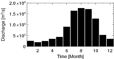
Due to monsoonal rains, which occur between mid-May and mid-October, the volume of the Irrawaddy and its tributaries varies greatly throughout the year. In summer, the melting of the snow[27] and glaciers in Northern Burma add to the volume. The average discharge near the head of the delta is between a high of 32,600 cubic metres (1,152,000 cubic feet) and a low of 2,300 cubic metres (82,000 cubic feet) per second. Over a year, the discharge averages 13,000 cubic metres (460,000 cubic feet). Further North, at Sagaing, the hydrograph shows a 38% decrease in discharge compared to where the river enters the delta.[28]
Variation between high and low waterlevel is also great.[29] At Mandalay and Prome, a range of 9,66 metre (31,7 feet) and 11,37 metre (37,3 feet) respectively has been measured between low-water level and floodlevel. Because of the monsoonal character of the rain, the highest point is recorded in August, the lowest in February.
This variation in water level makes it necessary for ports along the river to have separate landing ports for low- and high-water.[30] Still, low water levels have caused problems for ports along the river,[31] as in the Bamaw–Mandalay–Pyay sectors, the shallowest point is as shallow as 2 feet.[32]
Within the basin, the average population density is 79 people/km². For these people, the river supply amounts to 18,614 m³ per person per year.[33]
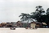
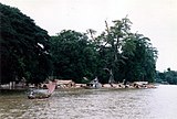
Ecology
.jpg)
.jpg)
The Irrawaddy river is home to a large diversity of animals, including about 43 fishspecies.[34]
The most well-known of these species is the Irrawaddy Dolphin (Orcaella brevirostris), a euryhaline species of Oceanic dolphin with a high and rounded forehead, lacking a beak. It is found in discontinuous sub-populations near sea coasts and in estuaries and rivers in parts of the Bay of Bengal and South-East Asia.
Along the North-South course of the Irrawaddy River, a number of notably different ecoregions can be distinguished.
Northern Mountains
The streams of the Nmai and Mali that form the Irrawaddy originate in high and remote mountains near the border with Tibet. This part of Burma, which extends north from Myitkyina and the Irrawaddy confluence, lies entirely outside the tropics. Rain falls at all seasons of thy year, but mostly in the summer. The valleys and lower hill ranges are covered with tropical and subtropical evergreen rainforest instead of monsoon (deciduous) forest. This region is characterised by subtropical and temperate forests of oak and pine are found at elevations above 3,000 feet (900 metres). This evergreen forest passes into sub-tropical pine forest at about 5000 feet Above 6,000 feet (1,800 metres), are forests of rhododendrons, and that in turn into evergreen conifer forest above 8000 feet.
The Central Basin and Lowlands
The Central Basin consists of the valley of the middle Irrawaddy and lower Chindwin. It lies within the 'dry zone' and consists almost enterirely of plains covered with the teak-dominated Irrawaddy Moist Deciduous Forest ecoregion surrounding drier patches of dry forests. The central basin receives little rain (ave 650mm per year) although it does flood quickly during the July-October storms. The one meteorological factor, and that is the most important for plant life, which does not greatly vary is atmospheric humidity. This is always high, except locally, in the winter. It usually does not fall below 75% and is 90% or more for long periods during summer. Another feature is the prevalent southerly summer winds which erode the soil of the basin.
The natural habitats of this central zone have been much altered for farming and there are few protected areas.
Irrawaddy dry forests
The predominant trees of the drier patches are the thorny Terminalia oliveri and the hardwood dahat teak (Tectona hamiltoniana) with stands of Indaing Dipterocarpus tuberculatus which is cut for timber. The wildlife includes many birds, small mammals and reptiles such as the huge Burmese python. However most of the large animals including the tiger have been hunted out or seen their habitats disappear.
Irrawaddy Delta Area

The Irrawaddy River and it's tributaries flow into the Andaman Sea through the Irrawaddy Delta. This ecoregion consists of mangroves and freshwater swamp forests. It is an extremely fertile area because of the riverborne silt deposited in the delta. The upper and central portions of the delta are almost entirely under cultivation, principally for rice. The southern portion of the ecoregion transitions into the Myanmar Coast mangroves [35] and is made up of fanlike marshes with oxbow lakes, islands, and meandering rivulets and streams.[36][37]
Birds of the delta are both winter visitors and passage migrants including Phalacrocorax carbo, a wide variety of Anatidae, Fulica atra, about 30 species of migratory shorebirds, Chlidonias hybrida, Hydroprogne caspia and the Brown-headed Gull (Larus brunnicephalus), which is very common. One of the most numerous wintering shorebird is the Lesser Sand Plover (Charadrius mongolus), which occurs in flocks of many thousands along the outer coast of the delta. The Wood Sandpiper and Red Junglefowl (Tringa glareola) are also abundant.
In the late 19th century, the Spot-billed Pelican (Pelecanus philippensis) nested in huge numbers in south Burma. One colony on the Sittang plain to the east of the delta was described in November 1877 as covering 100 square miles (300 km2) and containing millions of birds. Immense colonies still bred in the area in 1910, but the birds had disappeared completely by 1939. Small numbers were regularly reported in the delta in the 1940s, but no breeding sites were located. No pelicans have been recorded in recent years, and it may well be that the species is now extinct in Burma.[38]
Several species of large mammal occur in the delta, but their populations are small and scattered, with the possible exceptions of the Malayan Sambar (Cervus unicolor equinus), Hog Deer (C. porcinus) and Wild Boar(Sus scrofa), which have been reported from all Reserved Forests. Asian Elephants (Elephas maximus) were once widespread throughout the country with numbers as high as 10,000 animals, but in de last decade numbers have dwindled, partly due to transferring the animals to logging camps.[39] Other species reported to be present include the Leopard, Bengal Tiger, Crab-eating macaque, Wild Dog and otters (Panthera pardus, P. tigris, Cuon alpinus and Lutraspecies).[40]
The estuarine crocodile (Crocodylus porosus) can be found in the Southern part of the river delta. The species was formerly abundant in coastal regions of Burma, but is now known principally from the lower Ayeyarwady Delta. Population numbers have decreased because of a combination of commercial skin hunting, habitat loss, drowning in fishing nets and over-collection of living animals to supply crocodile farms.[41]
Despite recent declines in the Sea Turtle populations, five species are known to nest in Burma at well known island and mainland beaches known as turtle-banks. These are the Olive Ridley (Lepidochelys olivacea), loggerhead(Caretta caretta), green (Chelonia mydas), hawksbill (Eretmochelys imbricata), andleatherback(Dermochelys coriacea) marine turtles.[42]
Tributaries
The Irrawaddy River has five major tributaries. As they flow through the northern tip of Burma — the Kachin State — they cut long north-south alluvial plains and relatively narrow upland valleys between the 7,000 to 10,000 ft mountain ridges.[43] The rivers joining the Irrawaddy are, from north to south:
Economy and politics

As early as the sixth century, ancestors of the Burmese were using the Irrawaddy river, which runs through the center of Burma, to gain power in the region through trade and transport on the China - India route. By the twelfth century, a well-developed network of irrigation canals made for flourishing rice cultivation. Later, the river became a key economic tool of British interests, who set up trading ports along its shores.[44]
Today, the Irrawaddy is still the country's most important commercial waterway. Despite Mandalay's position as the chief rail and highway focus in northern Burma, a considerable amount of passenger and goods traffic moves by river. As the Irrawaddy Delta is one of the world's major rice-growing areas, one of the most important goods transported is rice. Teak logs - Myanmar is one of the world's top exporters - are floated down the river as large rafts. Before it is transported, teak has to be seasoned, because otherwise it won't float.[45] This happens by girdling, a practice where a deep circular cut through bark and sap is made into the heartwood. Other major goods that are transported from the nation's heartlands to Yangon for export are other foodstuffs, petroleum, cotton, and local commodities.
Commercial transportation on the Irrawaddy is maintained for about 1,300 km: from Hinthada to Bhamo (1,080 km) throughout the year, but from Bhamo to Myitkyina (200 km) for only seven months. More than 3,200 km of navigable waterways exist in the Irrawaddy delta, and there is a system of connecting canals. The Sittang is usable by smaller boats, but the Salween, because of its rapids, is navigable for less than 160 km from the sea. Small steamers and country boats also serve the coasts of the Rakhine and Tenasserim regions. On the Chindwin River, transportation is carried on by steam or diesel vessels throughout the year up to Homalin—about 640 km from its confluence with the Irrawaddy. Seasonal navigation is carried on into Tamanthi, which is 57 miles (92 km) by river above Homalin.
The Chindwin valley has no railroad and relies heavily on river transport. Chauk, downstream from the confluence in the oil-field district, is a petroleum port. It is linked to Yangon by road and rail. Hinthada, near the apex of the delta, is the rail junction for lines leading to Kyangin and Bassein (Pathein). A ferry operates between Hinthada on the west bank and the railway station at Tharrawaw on the east bank.
Dams
Burma's junta signed an agreement with China Power Investment Corporation in May 2007 for the construction of seven hydroelectric dams along the Irrawaddy, Mali, and N'Mai River in Kachin State. The total planned output of all seven plants will be 13,360 MWs of electricity, making it the largest hydropower project in Burma, surpassing the 7,100 MW TaSang Dam in Shan State.[46] The following data is available for the dam locations:
| Location | Myitsone | Chibwe | Pashe | Lakin | Phizaw | Khaunglanphu | Laiza |
|---|---|---|---|---|---|---|---|
| Height (m) | 152 | 47,5 | - | - | - | - | - |
| Length (m) | 152 | 220 | - | - | - | - | - |
| Capacity (MW) | 3,600 | 2,000 | 1,600 | 1,400 | 1,500 | 1,700 | 1,560 |
The power generated by the dams will be transmitted to other countries in the South-East Asian region, with most going to China.[47] Other countries targeted for power export are Thailand, India and Bangladesh.
The largest of the seven, the Myitsone Dam, is located at the confluence of the Mali and N'Mai Rivers at the creation of the Irrawaddy. Although the China Power Investment Corporation is project manager of the Confluence Region Hydropower Projects.[48] ParConfluence Region Hydropower Projects, several companies have been or are currently involved in the preparation, construction and financing of the 3,600 MW Myitsone Dam. Asia World Company has a key position, amidst Burmese Suntac Technologies and state-run Myanmar Electrical Power Enterprise, a state-owned utility enterprise responsible for power generation, transmission and distribution[49]
Chinese involvement comes from China Power Investment Corporation, China Southern Power Grid, Yunnan Machinery Equipment Import & Export Company and Changjiang Institute of Surveying, Planning, Design and Research.
At least one Japanese company is involved, Kansai Electric Power Company.[50]
Controversy
Due to its location and size, construction of the Myitsone Dam has raised significant ecological and sociological concerns. According to the Irrawaddy Myitsone Dam Multipurpose Water Utilizing Project study, the maximum water level of the reservoir wil be 290 metres. This makes for a flood zone of 766 km2, compromising 47 villages.[51]
Other consequences of the inundation include loss of farmland, loss of spawning habitat as fishes can not swim upstream anymore. The Kachin Development Networking Group, a network of civil society groups and development organisations in Kachin State warn this will lead to a loss of income for fishermen. They report locals are also worried about the flooding of cultural sites in the flood zone. As with other large dam projects, the Myitsone Dam construction will alter the hydrological characteristics of the river, e.g. preventing sediment from enriching riverbanks downstream, where it usually enriches the riverside foodproducing plains.[52] This can affect fertility as far downstream as the Irrawaddy Delta, the major rice-producing area of Myanmar.
Ecological concerns focus on the inundation of an area that is the border of the Indo-Burma and South Central China biodiversity 'hotspots'. The Mali and N'mai River confluence region falls within the Mizoram-Manipur-Kachin rainforests, added to the WWF list of outstanding examples of biodiverse regions.[53]
The location of the Myitsone Dam, located less than 100 km from a fault line where the Eurasian and Indian tectonic plates meet, raised concerns about its earthquake resistance. Recent earthquakes in the region, such as the 5.3 magnitude earthquake that struck near the Burma-China border on August 20, 2008,[54] prompted Naw Lar, the coordinator of the KDNG dam research project, to ask the junta to reconsider its dam projects.[55]
Major cities and towns

The river flows through the following cities:
Bridges

Until the construction of the Ava (Innwa) Bridge, a 16 span rail and road cantilever bridge built by the British colonial government in 1934, the only way across the Irrawaddy was by ferry. The bridge was destroyed by the retreating British Army during the World War II and was rebuilt in 1954 after Burmese independence and was the only bridge to span the Irrawaddy until recent times when a spate of bridge construction has been carried out by the government.[56][57]
- Ayeyarwady Bridge (Yadanabon) just upstream from the old Ava Bridge at Sagaing
- Bala Min Htin Bridge over the N'Mai Hka at Myitkyina, November 1998
- Anawrahta Bridge at Chauk, April 2001[58]
- Ayeyarwady-Magway Bridge at Magway
- Bo Myat Tun Bridge at Nyaungdon, November 1999
- Nawaday Bridge at Pyay, September 1997
- Maubin Bridge at Maubin, February 1998
- Ayeyarwady-Dedaye Bridge at Dedaye[59]
Gallery
-
 River Irrawaddy with Mandalay Hill on the east bank
 -
 Travelling on the great river
 -
 Traditional rivercraft on the Irrawaddy
 -
 Buffalo pulling logs from the Irrawaddy at Mandalay
 -
 The great river at Mingun
 -
 An island village on the Irrawaddy stays above water on stilts during the monsoons
 -
 Bamboo rafts by the Irrawaddy
 -
 Market on the west bank at Mingun
 -
 Bamboo raft sailing down the Irrawaddy
 -
 Woman sailing in small boat along the west bank at Mingun


Notes
- ^ Irrawaddy etymology
- ^ California State University, Chico - The Symbolism of Elephants in Indian Culture retrieved July 13, 2009
- ^ influence of Indian culture on South-East Asia paragraph 10. Retrieved July 13, 2009
- ^ Himachalworld describing the Ravi and its tributaries, retrieved July 13, 2009
- ^ Translation of Sanskrit Airaavata on the 'spoken Sanskrit.de dictionary, retrieved July 15, 2009
- ^ Harvey G.E. (2000) History of Burma Laurier Book Ltd. p6 footnote 2
- ^ Brian D Smith; et al. Asian Marine Biology 1997:Investigation of Cetaceans in the Ayeyarwady River and Northern Coastal Waters of Myanmar. Hong Kong University Press. p. 173. ISBN 9789622094628. Retrieved 2008-10-06.
{{cite book}}: Explicit use of et al. in:|author=(help) - ^ Tint Tun. "Irrawaddy Dolphin". Retrieved 2008-10-06.
- ^ Document about the floradiversity in Northern Kachin, in the N'mai watershed. Studies on Floradiversity of North-eastern Kachin Myanmar Section of Sino-himalaya (N'mai Hka-Than Lwin Water Division) - Ma Kalayar Lu, Myitkyina University, faculty of Botanics, 28-8-06. retrieved 6-12-2008.
- ^ Burma Rivers Network, paragraph 3. Retrieved July 14, 2009
- ^ James R Penn (2001) Rivers of the World. Santa Barbara, Calif. [u.a.] ABC-Clio ISBN 1-57607-042-5 9781576070420. Page 115 paragraph 2, retrieved July 16, 2009/
- ^ Encyclopedia Britannica Online topic: Physical features » Physiography, paragraph 3. Retrieved 5-12-2008
- ^ Kabwet, Myanmar: topografische & klimatografische informatie over Kabwet
- ^ Global Volcanism Program - vulcanologic ranking.
- ^ Location of Kyaukmyaung in Google Maps geocode
- ^ "All areas with P/PET ratio less than 0.65" according to the definition of the Convention on Biological Diversity, retrieved 16-12
- ^ Thomas Streissguth, Myanmar in pictures, Twenty-First Century Books, 2007. ISBN 0-8225-7146-3. Retrieved 16-12.
- ^ Rakhine State op Travel Myanmar
- ^ Rakhine Mountain Range on The Free Dictionary Encyclopedia
- ^ Article about the Bago Mountains on Encyclopedia Britannica Online.
- ^ Basic information about the Bago Division on the site of the Myanmar Government
- ^ Information about sediment dynamics in the Yangon River at the site of National Center for Biotechnology Information. Retrieved 17/12/2008
- ^ Profile of the Irrawaddy Delta from Henzhada to the river mouth, in feet
- ^ Map on the rainfall in Myanmar retrieved 17-12-2008.
- ^ A detailed documentation of sediment dynamics can be found in The Journal of Geology
- ^ Encyclopedia Britannica Online Physiography, alinea 4. Retrieved 17-12-2008.
- ^ Hydrological Modeling of Large-scale Ungauged Basin Case Study: Ayeyarwady (Irrawaddy) Basin, Myanmar (2006), University of Yamanashi & ICHARM by Ali Chavoshian, H. Ishidaira, K. Takeuchi and J. Yoshitani, p. 6 fig. 6. Retrieved July 18, 2009
- ^ UNC & GNRDC Composite Runoff Fields for the Irrawaddy. Retrieved July 18, 2009
- ^ "Irrawaddy River - hydrology." Encyclopædia Britannica. 2009. Encyclopædia Britannica Online. 17 Jul. 2009.
- ^ "Irrawaddy River - hydrology." Encyclopædia Britannica. 2009. Encyclopædia Britannica Online. 17 Jul. 2009 <http://www.britannica.com/EBchecked/topic/294719/Irrawaddy-River
- ^ Low Water Level in Irrawaddy Threatens Commercial Port, Democratic Voice of Burma, March 6, 2009. Retrieved July 18, 2009
- ^ 'Shallow Irrawaddy', Today in Myanmar, published February 25, 2009. Retrieved July 18, 2009
- ^ Water Resources eAtlas page 2. 1995 data, retrieved July 16, 2009
- ^ List of fish species in the Ayeyarwady from [www.fishbase.org Fishbase.org], retrieved July 28, 2009.
- ^ World Wildlife website on Myanmar Coast mangroves, retrieved August 17, 2009
- ^ World Wildlife website on Irrawaddy Swamp Forests, retrieved August 17, 2009.
- ^ Wetlands in Myanmar, Asian Regional Centre for Biodiversity Conservation. Retrieved August 17, 2009
- ^ BirdLife Species Factsheet on the range of breeding Spot-Billed Pelican populations, retrieved August 8, 2009
- ^ Disappearing Wild Elephants, Environment issue 1, 2008. Retrieved August 2, 2009
- ^ Irrawaddy Delta Fauna, Asian Regional Centre for Biodiversity Conservation, retrieved August 8, 2009.
- ^ A population survey of the estuarine crocodile in the Ayeyarwady Delta, Oryx Volume 34 Issue 4, Pages 317 - 324. Retrieved August 8, 2009.
- ^ http://www.seaturtle.org/mtn/archives/mtn88/mtn88p10.shtml Sea Turtles in Myanmar: Past and Present, Marine Turtle Newsletter] 88:10-11 from Seaturtle.org, retrieved August 8, 2009.
- ^ Burma: Sahibs in the Shan States, The Politics of Heroin in Southeast Asia (1972), Alfred W. McCoy with Cathleen B. Read and Leonard P.Adams II. Chapter 3 "The Colonial Legacy", paragraph "Burma: Sahibs in the Shan States. Retrieved August 2, 2009.
- ^ Irrawaddy River (2009). In Encyclopædia Britannica. Retrieved August 06, 2009, from Encyclopædia Britannica.
- ^ Entry on teak at the 1911 Encyclopedia. Retrieved August 7, 2009
- ^ Saviours Sought To Halt Irrawaddy River Dam Project (14 March 2009) Nawdin Lahpai on Kachin News. Retrieved September 17, 2009.
- ^ China in Burma: The Increasing Investment of Chinese Multinational Corporations in Burma's Hydropower, Oil and Natural Gas and Mining Sectors (2008) [http://www.earthrights.org/ EarthRights International. Retrieved September 17, 2009
- ^ Supervisory Office of Confluence Region Hydropower Project Opened on the Myanmar Information Website May 7, 2007. Paragraph 4. Retrieved September 17, 2009
- ^ Tin Maung Maung Than. (2005). Myanmar's Energy Sector: Banking on Natural Gas Myanmar's Energy Sector: Banking on Natural Gas In Chin Kin Wah & Daljit Singh (Eds.), Southeast Asian Affairs 2005 (pp. 257-289). Singapore: Institute of Southeast Asian Studies.
- ^ Damming the Irrawaddy (2008) Chiang Mai (Kachin Environment Organization, Kachin Development Networking Group. Retrieved September 17, 2009
- ^ Damming the Irrawaddy p. 39 (2008) Chiang Mai (Kachin Environment Organization, Kachin Development Networking Group. Retrieved September 22, 2009
- ^ William L. Graf (1999) Dam nation: A geographic census of American dams and their large-scale hydrologic impacts, Water Resrouces Research, Vol. 35(4) pp. 1305-1311
- ^ Mizoram-Manipur-Kachin rain forests (IM0131) [http://www.worldwildlife.org/ World Wildlife Foundation] page on Tropical and Subtropical Moist Broadleaf Forests in the Indo-Malay Region.. Retrieved September 22, 2009
- ^ Earth Quake Hits China-Burma Border, article in the Sydney Morning Herald on August 20, 2008. Retrieved online September 24, 2009
- ^ Earthquake Raises Concern over Mega Dams, August 20, 2009. Retrieved September 24, 2009.
- ^ ""Big Push" for Sustained Development". Perspective, August 2000. Retrieved 2008-10-06.
{{cite web}}: Italic or bold markup not allowed in:|publisher=(help) - ^ "Roads and Bridges". Union Solidarity and Development Association April 7, 2006. Retrieved 2008-10-06. [dead link]
- ^ "Sr General Than Shwe attends opening of Anawrahta Bridge linking Chauk and Seikphyu on Ayeyawady River". The New Light of Myanmar, April 5, 2001. Retrieved 2008-10-06.
{{cite news}}: Italic or bold markup not allowed in:|publisher=(help) - ^ "The Nation's Longest Bridge Inaugurated". Perspective, November 1999. Retrieved 2008-10-06.
{{cite web}}: Italic or bold markup not allowed in:|publisher=(help)