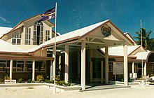
Yaren District
0°32′52″S 166°55′15″E / 0.5477°S 166.920867°E

Yaren, in earlier times Makwa/Moqua, is a district and constituency of the Pacific nation of Nauru. It is the de facto capital of Nauru.

Yaren is located in the south of the island [1]. Its area is 1.5 km2 (0.58 sq mi), and its population was 1,100 in 2003. To the north of Yaren is Buada, to the east is Meneng and to the west is Boe.
Government and administrative buildings
The following government offices are located in this district:
- the Parliament House
- the earth station
- the administration offices
- the police station
- the Nauru International Airport and the air terminal
Yaren (and sometimes Aiwo) is usually listed as the capital of Nauru though this is incorrect; the republic does not have cities or an official capital. Yaren is accepted by the United Nations as the "main district".
Constituency
Yaren also constitutes a political constituency. It returns two members to the Parliament of Nauru.
Main sights
- The Moqua Well is situated in Yaren.
References

