
Portreath: Difference between revisions
Partial rewrite, adding History section |
add a little more |
||
| Line 19: | Line 19: | ||
| os_grid_reference = SW655455 |
| os_grid_reference = SW655455 |
||
}} |
}} |
||
'''Portreath''' is a village, [[civil parish]] and fishing port |
'''Portreath''' is a village, [[civil parish]] and fishing port on the north coast of [[Cornwall]], [[England]], [[United Kingdom|UK]], about 5 km north of the town of [[Camborne]]. The village extends for about 1 km down the valley of the Red River, clinging to both slopes, towards the main centre around the harbour and parade of shops, about 300 metres from the seafront. Further up the valley are small clothing factory outlets. Today its sandy beach and surf are popular with holidaymakers. |
||
==History== |
==History== |
||
The name Portreath (meaning "sandy cove") was first recorded in 1485. [[Dartmoor_tin-mining#Streaming|Tin streaming]] in the valley was recorded from 1602, and the first quay was built in 1713 near Amy's Point,<ref name="CISI">{{cite web |
|||
| ⚫ | |||
|url=http://www.historic-cornwall.org.uk/cisi/portreath/CISI_Portreath_report.pdf |
|||
|title=Cornwall Industrial Settlements Initiative - Portreath |
|||
|publisher=Cornwall County Council, Historic Environment Service |
|||
|date=March 2002 |
|||
|accessdate=2009-07-02}}</ref> though it was destroyed by the sea before 1749.<ref>{{cite web |
|||
|url=http://www.heartofcornwall.com/pages/portreath.htm |
|||
|title=Cornwall Online's Portreath pages |
|||
|publisher=Cornwall Online |
|||
|accessdate=2009-07-02}}</ref> The village also had a fishing fleet, mainly for [[pilchard]]s.<ref name="CISI"/> |
|||
| ⚫ | In the late 1770s, during the [[American Revolutionary War#An international war, 1778–1783|American Revolutionary War]], lieutenant-colonel of the North Devon militia, [[Francis Basset, 1st Baron de Dunstanville and Basset|Francis Basset]], commanded local miners to fortify the port, which helped counter a Franco-Spanish invasion fleet gathered as part of the European theatre of the war.{{Fact|date=July 2009}} |
||
In the 19th century, Portreath was, with [[Devoran]] on the south coast, one of the main ports for sending the copper ore mined in the [[Mining_in_Cornwall#Gwennap.2C_Cornwall.27s_.22Copper_Kingdom.22|Gwennap area]] to [[Swansea]] for [[smelting]]. The ships returned with welsh coal to fire the steam engines used on the mines. The two rectangular basins that today make up the harbour and the long breakwater just below the cliffs were all built for this trade. The peak of this enterprise was around 1840, when some 100,000 tons of copper ore were shipped out each year.<ref name="MHC">{{cite book |
In the 19th century, Portreath was, with [[Devoran]] on the south coast, one of the main ports for sending the copper ore mined in the [[Mining_in_Cornwall#Gwennap.2C_Cornwall.27s_.22Copper_Kingdom.22|Gwennap area]] to [[Swansea]] for [[smelting]]. The ships returned with welsh coal to fire the steam engines used on the mines. The two rectangular basins that today make up the harbour and the long breakwater just below the cliffs were all built for this trade. The peak of this enterprise was around 1840, when some 100,000 tons of copper ore were shipped out each year.<ref name="MHC">{{cite book |
||
Revision as of 19:25, 2 July 2009
| Portreath | |
|---|---|
 Portreath harbour at low tide | |
| Population | Expression error: "1,337 (2001)" must be numeric |
| OS grid reference | SW655455 |
| Unitary authority | |
| Ceremonial county | |
| Region | |
| Country | England |
| Sovereign state | United Kingdom |
| Post town | REDRUTH |
| Postcode district | TR16 |
| Dialling code | 01209 |
| Police | Devon and Cornwall |
| Fire | Cornwall |
| Ambulance | South Western |
| UK Parliament | |
Portreath is a village, civil parish and fishing port on the north coast of Cornwall, England, UK, about 5 km north of the town of Camborne. The village extends for about 1 km down the valley of the Red River, clinging to both slopes, towards the main centre around the harbour and parade of shops, about 300 metres from the seafront. Further up the valley are small clothing factory outlets. Today its sandy beach and surf are popular with holidaymakers.
History
The name Portreath (meaning "sandy cove") was first recorded in 1485. Tin streaming in the valley was recorded from 1602, and the first quay was built in 1713 near Amy's Point,[1] though it was destroyed by the sea before 1749.[2] The village also had a fishing fleet, mainly for pilchards.[1]
In the late 1770s, during the American Revolutionary War, lieutenant-colonel of the North Devon militia, Francis Basset, commanded local miners to fortify the port, which helped counter a Franco-Spanish invasion fleet gathered as part of the European theatre of the war.[citation needed]
In the 19th century, Portreath was, with Devoran on the south coast, one of the main ports for sending the copper ore mined in the Gwennap area to Swansea for smelting. The ships returned with welsh coal to fire the steam engines used on the mines. The two rectangular basins that today make up the harbour and the long breakwater just below the cliffs were all built for this trade. The peak of this enterprise was around 1840, when some 100,000 tons of copper ore were shipped out each year.[3]
To the south of the harbour are the significant remains of the old cable-worked incline used by the Hayle Railway in the 19th and early 20th centuries to descend to the quayside. Today there is a 17.5 km public footpath and cycle track following the old mineral tramways from here across the county to Devoran on the south coast.[3]
RRH Portreath, a radar station operated by the RAF, was built in 1940 on Nancekuke Common to the north of the village.
Gallery
-
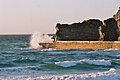
 The beach and Gull Rock at sunset
 -
 Portreath harbour mole


References
- ^ a b "Cornwall Industrial Settlements Initiative - Portreath" (PDF). Cornwall County Council, Historic Environment Service. March 2002. Retrieved 2009-07-02.
- ^ "Cornwall Online's Portreath pages". Cornwall Online. Retrieved 2009-07-02.
- ^ a b Hancock, Peter (2008). The Mining Heritage of Cornwall and West Devon. Wellington, Somerset: Halsgrove. pp. 66–68. ISBN 978 1 84114 733 6.
{{cite book}}: Check|isbn=value: checksum (help)
External links
- Portreath Parish Tram Web Site
- http://www.trencrom.freeserve.co.uk/portreath.htm
- http://www.heartofcornwall.com/pages/portreath.htm
- 8 photographs of Portreath at WestCountryViews.co.uk
- A Brief history of Portreath
Cornwall Record Office Online Catalogue for Portreath
| Unitary authorities | |
|---|---|
| Major settlements (cities in italics) |
|
| Rivers | |
| Topics | |
This Cornwall location article is a stub. You can help Wikipedia by expanding it. |