Southern Lebanon: Difference between revisions
A.K.Khalifeh (talk | contribs) No edit summary |
|||
| Line 1: | Line 1: | ||
{{redirect|South Lebanon|other uses|South Lebanon (disambiguation)}} |
{{redirect|South Lebanon|other uses|South Lebanon (disambiguation)}} |
||
[[File:Mleeta, South Lebanon.jpg|thumb|Mleeta, South Lebanon]] |
|||
'''Southern Lebanon''' is the geographical area of [[Lebanon]] comprising the [[South Governorate]] and the [[Nabatiye Governorate]]. These two entities were divided from the same province in the early 1990s. The [[Rashaya District|Rashaya]] and [[Western Beqaa District|Western Beqaa]] Districts, the southernmost districts of the [[Beqaa Governorate]], in Southern Lebanon are sometimes included in this description. |
'''Southern Lebanon''' is the geographical area of [[Lebanon]] comprising the [[South Governorate]] and the [[Nabatiye Governorate]]. These two entities were divided from the same province in the early 1990s. The [[Rashaya District|Rashaya]] and [[Western Beqaa District|Western Beqaa]] Districts, the southernmost districts of the [[Beqaa Governorate]], in Southern Lebanon are sometimes included in this description. |
||
| Line 156: | Line 157: | ||
* [[South Lebanon conflict (1982–2000)]] |
* [[South Lebanon conflict (1982–2000)]] |
||
* [[North District (Occupied palastine)]] |
* [[North District (Occupied palastine)]] |
||
* [[Operation |
|||
* [[Operation Litani]] against the [[Lebanese National Movement]] |
|||
* [[United Nations Interim Force in Lebanon]] (instituted by [[United Nations Security Council Resolution 425]]) |
|||
* [[South lebanon security belt]] |
|||
==References== |
|||
{{reflist}} |
|||
For More Information Please Visit [http://www.southlb.com South Lebanon WebSite] |
|||
{{coord missing|Lebanon}} |
|||
[[Category:Geography of Lebanon]] |
|||
[[Category:Israeli–Lebanese conflict]] |
|||
[[Category:2006 Lebanon War]] |
|||
[[Category:Southern Levant]] |
|||
Revision as of 19:05, 14 December 2013

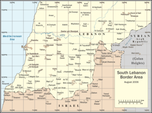
Southern Lebanon is the geographical area of Lebanon comprising the South Governorate and the Nabatiye Governorate. These two entities were divided from the same province in the early 1990s. The Rashaya and Western Beqaa Districts, the southernmost districts of the Beqaa Governorate, in Southern Lebanon are sometimes included in this description.
The main cities of the region are Sidon, Tyre, Jezzine and Nabatiyeh. The cazas of Bint Jbeil, Tyre, and Nabatieh in Southern Lebanon are known for their large Shi'a Muslim population with a minority of Christians. Sidon is predominately Sunni, with the rest of the caza of Sidon having a Shi'a Muslim majority, with a considerable Christian minority, mainly Greek Catholics. The cazas of Jezzine and Marjeyoun have a Christian majority and also Shia Muslims. The villages of Ain Ebel, Debel, Qaouzah, and Rmaich are entirely Christian Maronite. The caza of Hasbaya has a Druze majority.
Southern Lebanon has featured prominently in the Israel-Lebanon conflict.
Ahmadinejad's state visit
In October 2010 Iranian President Mahmoud Ahmadinejad visited South Lebanon. This was his first visit to Lebanon since he first assumed office in Tehran in 2005. Both Israel and the United States condemned the trip as being "provocative." Ahmadinejad was welcomed by tens of thousands of supporters of Hezbollah, Iran's Shiite Muslim ally in Lebanon which the United States and Israel have branded a terrorist organization, despite its participation in Lebanon's fragile government.
Cities and districts


- Al Rihan
- Aalma ach Chaab (Alma ash Shab)
- Abbasieh
- Adasse or Adaisseh or Addaisseh
- Adlun
- Al Mansuri
- Ain Ebel
- Ain Baal or Ayn Bal
- Aitaroun or Aytarun
- Ansariyeh or Insariye
- Ansar
- Ash Shawmara
- At Tayyabah
- At Tiri
- Aitit
- Aynata
- Ayta al-Sha`b (Ayta)
- Baraachit
- Barish
- Bayt Lif
- baytulay
- Bazouryeh
- Beit Yahoun
- Bint Jbeil
- Blida, Lebanon
- Borj el Shamali or Borj Chemali
- Borj Qalaouiyeh
- Borj Rahal
- Boustane
- Brashit
- Braikeh
- Chaqra
- Chtoura
- Deir Kifa
- Deyrintar
- Dayr Qanun
- Derdghaya
- Dibil or Debel
- Doueir
- Ebel el Saki
- El Biyyadah or Al Bayyadah
- El Hennyeh or Al Hinniyah
- El Mansoun or Al Mansuri
- El Qlaile or Al Qulaylah
- El Soultaniyeh
- Frun
- Ghandouriyeh
- Jabal Amel
- jebchet
- Jmaijmah
- Joiya or Jouaya or Jwayya
- Ghaziyeh
- Ghassaniyeh
- Hadata or Haddathah
- Hanaway
- Harris or Harres
- Houla or Hula
- Hounin
- Kabrikha or Qabrikha
- kaakaeit al jesser
- Kafr Dunin
- Kafr Kila
- Kfarmelki or Kfar Melky
- Kafarrouman
- Khirbet Selm
- Kfarchouba
- Kfarfila
- Kfarhamam
- Kfar Tebnit
- Kounin
- Maachouq
- Mahrouna
- Markaba
- Marakeh
- Majdel Balhis
- Majdel Selm or Majdal Zun
- Marqaba or Markaba
- Maroun al-Ras
- Marwahin
- Maaroub
- Meidoun
- Meiss el Jabal or Mays al Jabal
- Mlikh
- Nabatiye or Nabatiyeh
- Naqoura or Nakoura or An Naqurah
- Niha[disambiguation needed]
- Majdal Zun
- Marjayoun -- a Lebanese Christian village [1]
- Oum el Ahmad
- Qlayaa
- Qana
- Qantara
- Khiam
- Wadi al-Taym
- Rachaf -- a small town
- Ramyah
- Ras Al-Biyada
- Rmaich
- Rmadyeh
- Roûm
- Selaa
- Shabriha
- Shebaa and/or Shebaa Farms (ownership disputed, occupied by Israel since 1967)
- Shihin
- Shhur
- Siddiqine
- Zibqin
- Sidon or Saida
- Srifa
- Sujod
- Tallousa
- Tair Debbe
- Tayr Harfa or Tair Harfa
- Tayr Falsayh
- Taibeh
- Tebnine or Tibnin or Tibneen [2] Site of the former castle town Toron
- Toulin or Tulin
- Tura
- Tyre or Sur
- Saida district
- Jezzine district
- Tyre district
- Yarin
- Yaroun or Yarun
- Yahun
- Yatar or Yater
- Zibdine
- Zibqeen
Other notable geographic sites
- Abou Assouad River
- Awali River
- El Zahrani River
- Litani River
- Saitaniq River
- Kasmieh River
- Blue Line (Lebanon)
- Beaufort Castle
- Several Palestinian refugee camps in Lebanon including Ain al-Hilweh, Nabatieh camp and Wavel.
