
Gambier Islands: Difference between revisions
mNo edit summary |
m Dating maintenance tags: {{Fact}} |
||
| (206 intermediate revisions by more than 100 users not shown) | |||
| Line 1: | Line 1: | ||
{{About|the Gambier Islands located in Polynesia |the Island in Canada|Gambier Island|the Islands in South Australia|Gambier Islands (South Australia) }} |
|||
The '''Gambier Islands''' ([[French language|French]]: ''Îles Gambier'' or ''Archipel des Gambier'') are a small group of islands in [[French Polynesia]], located at the southeast terminus of the [[Tuamotu]] archipelago. They are generally considered a separate island group from Tuamotu both because their culture and language ([[Mangarevan language|Mangarevan]]) are much more closely related to those of the [[Marquesas Islands]], and because, while the Tuamotus are comprised of several chains of [[coral]] [[atoll]]s, the Gambiers, especially the primary island, [[Mangareva]], are of volcanic origin. Because of its proximity, the nearby atoll of [[Temoe (Gambier Islands)|Temoe]] ({{coor dms|23|20|46|S|134|28|28|W|}}) is sometimes included among the Gambiers. |
|||
{{Location map |
|||
==Politics== |
|||
|Pacific Ocean |
|||
|label=Gambier Islands |
|||
|lon_dir=W |
|||
|lat_dir=S |
|||
|lat_deg=23|lat_min=9 |
|||
|lon_deg=134|lon_min=56 |
|||
|position=right |
|||
|width=300 |
|||
|float=right |
|||
|mark=Cercle rouge 100%.svg |
|||
|marksize=20 |
|||
|caption=Location of the Gambier Islands in the Pacific Ocean |
|||
}} |
|||
{{Infobox islands |
|||
|name = Gambier Islands |
|||
| image name = Flag of the Gambier Islands.svg |
|||
| image caption = [[Flag of the Gambier Islands]] |
|||
| image size = 125px |
|||
| locator map = Karta FP Gambier isl.PNG |
|||
| native name = Îles Gambier |
|||
| native name link = French language |
|||
| nickname = |
|||
| location = [[Pacific Ocean]] |
|||
| coordinates = |
|||
| archipelago = [[Polynesia]] |
|||
| total islands = 14 |
|||
| major islands = [[Mangareva]], [[Akamaru (Island)|Akamaru]], [[Aukena]], [[Taravai]] |
|||
| area km2 = 31 |
|||
| highest mount = |
|||
| elevation m = |
|||
| country = France |
|||
| country admin divisions title = [[Overseas collectivity]] |
|||
| country admin divisions = [[French Polynesia]] |
|||
| country capital city = |
|||
| country largest city = |
|||
| country largest city population = |
|||
| country leader title = |
|||
| country leader name = |
|||
|population = 1,641| population as of = 2007 |
|||
| ethnic groups = |
|||
| additional info = |
|||
}} |
|||
The '''Gambier Islands''' or '''Mangareva Islands''' ({{Lang-fr|Îles Gambier}} or {{Lang|fr|''Archipel des Gambier''}}) are a populated (1641 people) small ({{convert|30|km2}}) group of islands, namely remnants of a [[caldera]] along with islets on the surrounding [[fringing reef]], in [[French Polynesia]], located at the southeast terminus of the [[Tuamotu]] archipelago. They are generally considered a separate island group from Tuamotu both because their culture and language ([[Mangarevan language|Mangarevan]]) are much more closely related to those of the [[Marquesas Islands]], and because, while the Tuamotus comprise several chains of [[coral]] [[atoll]]s, the Gambiers are of volcanic origin with central high islands. Because of their proximity, the [[Acteon Group]], and the nearby atolls of [[Maria Est]], [[Morane (French Polynesia)|Morane]], [[Marutea Sud]] and [[Temoe (Gambier Islands)|Temoe]] ({{Coord|23|20|46|S|134|28|28|W}}) are sometimes included among the Gambiers. |
|||
==Administration== |
|||
Together with the [[Tuamotus]], the Gambier Islands form [[Îles Tuamotu-Gambier]] ([[French language|French]]: ''(les) (Îles) Tuamotu-Gambier'' or officially ''la subdivision administrative des (Îles) Tuamotu-Gambier''), one of the 5 primary administrative divisions (''subdivisions administratives'') of [[French Polynesia]]. |
|||
The commune of Gambier is made up of the Gambier Islands (with uninhabited Temoe Atoll 40 km southeast of the main Gambier group), the uninhabited [[Acteon Group]] to the northwest ([[Matureivavao]], [[Tenararo]], [[Tenarunga]], [[Vahanga]]), and the also uninhabited atolls of [[Marutea Sud]], [[Maria Est]] and [[Morane (French Polynesia)|Morane]]. This group of islands and atolls covers an area of 35 km². |
|||
Although these archipelagos are administered as a single municipality (commune), the main village is [[Rikitea]], on the largest island of [[Mangareva]]. |
|||
The Gambier Islands (Gambier), together with the islands in the eastern part of the [[Tuamotus]] (Anaa, Fangatau, Hao, Hikueru, Makemo, Napuka, Nukutavake, Pukapuka, Reao, Tatakoto and Tureia), form ''Îles Gambier et Tuamotu Est'', one of the 6 electoral districts (''circonscriptions électorales'') for the [[Assembly of French Polynesia]] (''Assemblée de la Polynésie française''). |
|||
The Gambier Islands comprises: |
|||
The municipality of Gambier is made up of the Gambier Islands (with uninhabited Temoe Atoll 40 km east of the main Gambier group), the uninhabited Actaeon group to the west (Matureivavao, Tenararo, Tenarunga, Vahanga), and the atolls of Marutea Sud, Maria and Morane. This group of islands and atolls covers an area of 35 <sup>2</sup>. |
|||
* Gambier Group: [[Papuri Island|Papuri]], [[Teauaone]], [[Tepapuri]], [[Puaumu]], [[Vaiatekeue]], [[Teauotu]], [[Apou]], [[Tuaeu]], [[Totegegie]], [[Tarauru Roa]], [[Gaioio]], [[Tenoko]], [[Rumarei]], [[Mangareva]], [[Aukena]], [[Tokorua]], [[Taravai]], [[Tepu Nui]], [[Angakauitai]], [[Motu-O-Ari]], [[Makapu]], [[Akamaru Island|Akamaru]], [[Mekiro]], [[Teohootepohatu]], [[Atumata]], [[Tauna]], [[Tekava]], [[Kouaku]], [[Motu Teiku]], [[Makaroa]], [[Manui]], [[Kamaka Island]] |
|||
* [[Acteon Group]]: [[Tenararo]], [[Vahanga]], [[Tenarunga]], [[Matureivavao]] |
|||
==Geography== |
|||
Apart from the above groups, it also includes [[Marutea Sud]], [[Maria Est]], [[Morane (French Polynesia)|Morane]] and [[Temoe]] islands. |
|||
The Gambiers are surrounded by a coral reef, which is broken by only three passages to the open sea. Besides Mangareva, the other notable islands of the group are [[Akamaru (Island)|Akamaru]] ({{coor dms|23|10|52|S|134|54|56|W|}}), Angakauitai, [[Aukena]] ({{coor dms|23|07|42|S|134|54|01|W|}}), Kamaka, Kouaku, Makapu, Makaroa, Manui, Mekiro and [[Taravai]] ({{coor dms|23|08|12|S|135|01|33|W|}}). These are, like Mangareva, volcanic in origin. A number of others are actually coral islands, including Kauku, Papuri, Puaumu, Totengengie and the Tokorua group. |
|||
Together with the [[Tuamotus]], the Gambier Islands form [[Îles Tuamotu-Gambier]] (French: ''(les) (Îles) Tuamotu-Gambier'' or officially ''la subdivision administrative des (Îles) Tuamotu-Gambier''), one of the five primary administrative divisions (''subdivisions administratives'') of French Polynesia. |
|||
The islands are located at {{coor dm|23|09|S|134|58|W|}}., and are approximately 31 km² (12 mi²) in area. The total population in the 1988 census was 620. The primary town is [[Rikitea]], located on Mangareva. The highest point in the Gambiers is Mt. Duff, on Mangareva, rising to 441 m along the island's south coast. |
|||
The Gambier Islands (Gambier), together with the islands in the eastern part of the [[Tuamotus]] ([[Anaa]], [[Fangatau]], [[Hao (French Polynesia)|Hao]], [[Hikueru]], [[Makemo]], [[Napuka]], [[Nukutavake]], [[Puka-Puka]], [[Reao]], [[Tatakoto]] and [[Tureia]]), form ''Îles Gambier et Tuamotu Est'', one of the 6 electoral districts (''circonscriptions électorales'') for the [[Assembly of French Polynesia]] (''Assemblée de la Polynésie française''). |
|||
==History== |
|||
==Geography== |
|||
There was a time (approximately the [[tenth century|tenth]] to the [[fifteenth century|fifteenth centuries]]) when the Gambiers hosted a population of several thousand people and traded with other island groups including the [[Marquesas Islands|Marquesas]], the [[Society Islands]] and [[Pitcairn Islands]]. However, excessive logging by the islanders resulted in almost complete [[deforestation]] on [[Mangareva]], with disastrous results for the islands' environment and economy. The folklore of the islands records a slide into civil war and even cannibalism as trade links with the outside world broke down, and archaeological studies have confirmed this tragic story. Today, the islands can support a population of only a few hundred. |
|||
[[File:Gambier9.png|thumb|Gambier Islands (Mangareva)]] |
|||
The Gambier Islands proper have an enclosing [[coral reef]] which is broken by only three passages to the [[open sea]]. Besides Mangareva, the other notable [[high island]]s of the group are [[Akamaru (Island)|Akamaru]], [[Angakauitai]], [[Aukena]], [[Kamaka Island|Kamaka]], [[Kouaku]], [[Makapu]], [[Makaroa]], [[Manui]], [[Mekiro]] and [[Taravai]]. These are primary of [[volcano|volcanic origin]]. A number of others are actually [[coral island]]s, hence of secondary volcanic origin, including [[Papuri Island|Papuri]], [[Puaumu]], [[Totengengie]] and the [[Tokorua]] group. |
|||
The islands proper are located at {{Coord|23|09|S|134|58|W}} and are approximately 31 km² (12 mi²) in area. The total population in 2007 was 1,641. The primary [[town]] is [[Rikitea]], located on Mangareva, as is the highest point in the Gambiers, [[Mt. Duff]], rising to {{convert|441|m}} along that [[island]]'s south coast. |
|||
===Effects of French nuclear testing on the Gambiers=== |
|||
The more distant [[atoll]]s of the Gambiers [[sensu lato|in the broad sense]] are all uninhabited. |
|||
(Due to the controversy surrounding the next section, each paragraph will be cited with a source or multiple sources where available. In some cases, the professional media has not been allowed to research this issue properly, due to the French government's restriction on foreign travel to the Gambiers. As a result, only first hand, previously unpublished information is available for certain facts. Stephen Midgley provides these facts. He lived on these islands for 7 months from January to July of 1993 and was able to interview many of the local islanders in depth over that time.) |
|||
[[File:Akamaru1.jpg|thumb|left|500px|Akamaru]] |
|||
The Gambiers served as a logistical staging base for [[France|French]] [[nuclear testing]] activity in [[Mururoa]]. During this time, the [[military of France|French military]] dragged chain through some of the [[coral reef]] beds to cut a wider and deeper channel for deep draft vessels. Subsequently, the reef fish population became infected with a disease which makes most of them inedible to humans (consumption produces symptoms including painful rashes, [[sensitivity (human)|sensitivity to light]] and itching which can persist for weeks and reoccur occasionally). |
|||
{{Clear}} |
|||
==History== |
|||
Sources: |
|||
{{Infobox French commune |
|||
* Stephen Midgley, on the ground interviews and research, January to July 1993) |
|||
|name = French commune of Gambier |
|||
* [http://observer.guardian.co.uk/international/story/0,6903,1676239,00.html Guardian UK] |
|||
|image = Commune.Gambier.JPG |
|||
|caption = A ship from Gambier |
|||
|map = French Polynesia relief map with communes.svg |
|||
|map caption = The Gambier Islands form the easternmost part of [[French Polynesia]] |
|||
|overseas collectivity = [[French Polynesia]] |
|||
|administrative subdivision= [[Îles Tuamotu-Gambier]] |
|||
|INSEE = 98719 |
|||
|postal code = 98755 |
|||
|mayor = Monique Labbeyi-Richeton |
|||
|term = 2008–2014 |
|||
|intercommunality = |
|||
|longitude = -134.94 |
|||
|latitude = -23.14 |
|||
|elevation min m = 0 |
|||
|elevation max m = 441 |
|||
|area km2 = 46 |
|||
|population = 1,641 |
|||
|population date = 2007 |
|||
|demonym = |
|||
|website = |
|||
}} |
|||
Approximately from the 10th to the 15th centuries, the Gambiers hosted a population of several thousand people and traded with other island groups including the Marquesas, the [[Society Islands]] and [[Pitcairn Islands]]. However, excessive [[logging]] by the islanders resulted in almost complete [[deforestation]] on Mangareva, with disastrous results for the islands' environment and [[economy]]. The [[folklore]] of the islands records a slide into [[civil war]] and even [[cannibalism]] as trade links with the outside world broke down, and [[archeology|archaeological]] studies have confirmed this tragic story. Today, the islands can support a population of only a few hundred. |
|||
Additionally, during the above-ground testing, local islanders were not provided with adequate protection, being housed in a [[sheet metal]] warehouse structure, with open ventilation to the outside. Many locals allegedly suspect that they were exposed to high levels of [[nuclear fallout|radiation]], and that their island continues to produce food that is not fit for consumption. Anecdotal reports of high [[cancer]] rates continue. |
|||
In 1834, the French [[Congregation of the Sacred Hearts of Jesus and Mary|Picpus]] priests [[Honoré Laval]] and [[François Caret]] with their assistant [[Columba Murphy]] founded a Roman Catholic mission in the Gambiers. After their success here, they moved to Tahiti in 1836. |
|||
Sources: |
|||
* Stephen Midgley, interviews and research on site, January to July 1993 |
|||
* [http://www.thebulletin.org/article.php?art_ofn=mar90danielsson Bulletin of the Atomic Sciences] |
|||
===Effects of French nuclear testing on the Gambiers=== |
|||
French military vessels visited the area (as of 1993) every six months collecting specimens of water, food, human hair and other material, as well as taking detailed accounts of births, deaths and other demographic events, presumably for on-going research into the effects of the nuclear testing. The results of this research are not known to be published anywhere. Many islanders resent this secrecy and suspect it is because they are experiencing serious consequences of the nuclear testing on Mururoa. (Source: Stephen Midgley, interviews and research on site, January to July 1993. Additionally Mr. Midgley personally witnessed a French naval vessel arrive at the islands, interact with the islanders and depart after 2-3 days in 1993). |
|||
The Gambiers served as a logistical staging base for [[France|French]] [[nuclear testing]] activity in [[Mururoa]]. During this time, the [[military of France|French military]] dragged a chain through some of the [[coral reef]] beds to cut a wider and deeper channel for deep draft vessels. Higher rate of intoxications by [[ciguatera]] were subsequently recorded.<ref>{{cite news|url=http://observer.guardian.co.uk/international/story/0,6903,1676239,00.html|publisher=The Guardian|title=French accused of Pacific nuclear cover-up|accessdate=2008-05-12 | location=London | first=Lindsay | last=Vincent | date=2006-01-01}}</ref> |
|||
French military vessels visited the area (as of 1993) every six months collecting specimens of water, food, human hair and other material, as well as taking detailed accounts of births, deaths and other demographic events, presumably for on-going research into the effects of the nuclear testing. {{Reference necessary|text=The results of this research are not published.|date=April 2010}} |
|||
Until the [[government of France|French government]] releases more data, the truth of these allegations will remain unknown. |
|||
According to French Polynesian doctors who have worked in the area, considerably higher than normal incidences of cancer and thyroid problems are found amongst Polynesians who live near the Moruroa atoll.{{fact|date=August 2015}} |
|||
The local islanders believe that the [[sinking of the Rainbow Warrior|sinking of the ''Rainbow Warrior'']] was related to these issues. (Source: Stephen Midgley, interviews and research on site, January to July 1993) |
|||
==Gallery== |
|||
The ''[[Rainbow Warrior]]'' was scheduled to visit Mangareva to take environmental and human samples for independent analysis. Many residents reportedly believe that this is a primary reason why the French government chose to destroy the ''Rainbow Warrior'', rather than to permit public examination of the effects of the testing program. (Source: Stephen Midgley, interviews and research on site, January to July 1993) |
|||
<gallery> |
|||
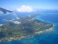
Image:Mangareva Vue aérienne.JPG|[[Mangareva]] |
|||
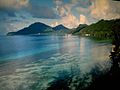
Image:Tour.de.guet.Aukena.2.JPG|[[Aukena]] |
|||
Image:Mangareva.jpg|[[Mangareva]] |
|||
File:Cathédrale Saint-Michel de Rikitea.2014.jpg|St Michael's Cathedral in [[Rikitea]], the largest church in the South Pacific built to seat 1200. |
|||
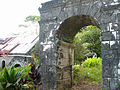
Image:Couvent.de.Rouru.JPG|Arch at the old Rouru's convent |
|||
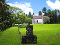
Image:Tombeau.du.Roi.JPG|Tomb of King [[Maputeoa]] |
|||
</gallery> |
|||
== See also == |
|||
Additional Sources related to sinking of Rainbow Warrior: |
|||
* [[ |
* [[List of non-marine molluscs of the Gambier Islands]] |
||
* [[List of monarchs of Mangareva]] |
|||
* [http://www.greenpeace.org.nz/about/rainbow-warrior.asp Greenpeace website] |
|||
* [http://news.bbc.co.uk/1/hi/sci/tech/4658065.stm BBC Report] |
|||
== |
==Notes== |
||
{{Reflist}} |
|||
==References== |
|||
*Jared Diamond, ''Collapse: How Societies Choose to Fail or Succeed'' (2005), Ch. 3 |
|||
==External links== |
|||
{{Commons category}} |
|||
{{Wikivoyage|Gambier Islands}} |
|||
*[http://www.pacific-image.pf/pages/boutic/dboutic_cdrom_sp132.html Atoll list (in French)] |
|||
*[http://www.janeresture.com/tahiti_mangareva/ Death of a People.] A look at the decline of Mangareva and the missionary influence on the people of the Gambiers. |
*[http://www.janeresture.com/tahiti_mangareva/ Death of a People.] A look at the decline of Mangareva and the missionary influence on the people of the Gambiers. |
||
==References== |
|||
*Jared Diamond, ''Collapse: How Societies Choose to Fail or Succeed'' (2005), Ch. 3 |
|||
{{Tuamotus}} |
|||
{{Polynesia}} |
|||
[[Category:Communes of French Polynesia]] |
|||
[[Category:Gambier Islands| ]] |
[[Category:Gambier Islands| ]] |
||
[[Category:Archipelagoes]] |
|||
[[ca:Illes Gambier]] |
|||
[[de:Gambierinseln]] |
|||
[[fr:Îles Gambier]] |
|||
[[ja:ガンビエ諸島]] |
|||
[[pt:Ilhas Gambier]] |
|||
[[fi:Gambiersaaret]] |
|||
[[sv:Gambier-öarna]] |
|||
Revision as of 12:24, 22 August 2015

 | |
| Geography | |
|---|---|
| Location | Pacific Ocean |
| Archipelago | Polynesia |
| Administration | |
France | |
| Demographics | |
| Population | 1,641 |
The Gambier Islands or Mangareva Islands (French: Îles Gambier or [Archipel des Gambier] Error: {{Lang}}: text has italic markup (help)) are a populated (1641 people) small (30 square kilometres (12 sq mi)) group of islands, namely remnants of a caldera along with islets on the surrounding fringing reef, in French Polynesia, located at the southeast terminus of the Tuamotu archipelago. They are generally considered a separate island group from Tuamotu both because their culture and language (Mangarevan) are much more closely related to those of the Marquesas Islands, and because, while the Tuamotus comprise several chains of coral atolls, the Gambiers are of volcanic origin with central high islands. Because of their proximity, the Acteon Group, and the nearby atolls of Maria Est, Morane, Marutea Sud and Temoe (23°20′46″S 134°28′28″W / 23.34611°S 134.47444°W) are sometimes included among the Gambiers.
Administration
The commune of Gambier is made up of the Gambier Islands (with uninhabited Temoe Atoll 40 km southeast of the main Gambier group), the uninhabited Acteon Group to the northwest (Matureivavao, Tenararo, Tenarunga, Vahanga), and the also uninhabited atolls of Marutea Sud, Maria Est and Morane. This group of islands and atolls covers an area of 35 km².
Although these archipelagos are administered as a single municipality (commune), the main village is Rikitea, on the largest island of Mangareva.
The Gambier Islands comprises:
- Gambier Group: Papuri, Teauaone, Tepapuri, Puaumu, Vaiatekeue, Teauotu, Apou, Tuaeu, Totegegie, Tarauru Roa, Gaioio, Tenoko, Rumarei, Mangareva, Aukena, Tokorua, Taravai, Tepu Nui, Angakauitai, Motu-O-Ari, Makapu, Akamaru, Mekiro, Teohootepohatu, Atumata, Tauna, Tekava, Kouaku, Motu Teiku, Makaroa, Manui, Kamaka Island
Apart from the above groups, it also includes Marutea Sud, Maria Est, Morane and Temoe islands.
Together with the Tuamotus, the Gambier Islands form Îles Tuamotu-Gambier (French: (les) (Îles) Tuamotu-Gambier or officially la subdivision administrative des (Îles) Tuamotu-Gambier), one of the five primary administrative divisions (subdivisions administratives) of French Polynesia.
The Gambier Islands (Gambier), together with the islands in the eastern part of the Tuamotus (Anaa, Fangatau, Hao, Hikueru, Makemo, Napuka, Nukutavake, Puka-Puka, Reao, Tatakoto and Tureia), form Îles Gambier et Tuamotu Est, one of the 6 electoral districts (circonscriptions électorales) for the Assembly of French Polynesia (Assemblée de la Polynésie française).
Geography

The Gambier Islands proper have an enclosing coral reef which is broken by only three passages to the open sea. Besides Mangareva, the other notable high islands of the group are Akamaru, Angakauitai, Aukena, Kamaka, Kouaku, Makapu, Makaroa, Manui, Mekiro and Taravai. These are primary of volcanic origin. A number of others are actually coral islands, hence of secondary volcanic origin, including Papuri, Puaumu, Totengengie and the Tokorua group.
The islands proper are located at 23°09′S 134°58′W / 23.150°S 134.967°W and are approximately 31 km² (12 mi²) in area. The total population in 2007 was 1,641. The primary town is Rikitea, located on Mangareva, as is the highest point in the Gambiers, Mt. Duff, rising to 441 metres (1,447 ft) along that island's south coast.
The more distant atolls of the Gambiers in the broad sense are all uninhabited.

History
French commune of Gambier | |
|---|---|
 A ship from Gambier | |
 The Gambier Islands form the easternmost part of French Polynesia | |
Location of French commune of Gambier  | |
| Country | France |
| Overseas collectivity | French Polynesia |
| Subdivision | Îles Tuamotu-Gambier |
| Government | |
| • Mayor (2008–2014) | Monique Labbeyi-Richeton |
| Area 1 | 46 km2 (18 sq mi) |
| Population (2007) | 1,641 |
| • Density | 36/km2 (92/sq mi) |
| INSEE/Postal code | 98719 /98755 |
| Elevation | 0–441 m (0–1,447 ft) |
| 1 French Land Register data, which excludes lakes, ponds, glaciers > 1 km2 (0.386 sq mi or 247 acres) and river estuaries. | |
Approximately from the 10th to the 15th centuries, the Gambiers hosted a population of several thousand people and traded with other island groups including the Marquesas, the Society Islands and Pitcairn Islands. However, excessive logging by the islanders resulted in almost complete deforestation on Mangareva, with disastrous results for the islands' environment and economy. The folklore of the islands records a slide into civil war and even cannibalism as trade links with the outside world broke down, and archaeological studies have confirmed this tragic story. Today, the islands can support a population of only a few hundred.
In 1834, the French Picpus priests Honoré Laval and François Caret with their assistant Columba Murphy founded a Roman Catholic mission in the Gambiers. After their success here, they moved to Tahiti in 1836.
Effects of French nuclear testing on the Gambiers
The Gambiers served as a logistical staging base for French nuclear testing activity in Mururoa. During this time, the French military dragged a chain through some of the coral reef beds to cut a wider and deeper channel for deep draft vessels. Higher rate of intoxications by ciguatera were subsequently recorded.[1]
French military vessels visited the area (as of 1993) every six months collecting specimens of water, food, human hair and other material, as well as taking detailed accounts of births, deaths and other demographic events, presumably for on-going research into the effects of the nuclear testing. [citation needed]
According to French Polynesian doctors who have worked in the area, considerably higher than normal incidences of cancer and thyroid problems are found amongst Polynesians who live near the Moruroa atoll.[citation needed]
Gallery
-
-

-
-
 St Michael's Cathedral in Rikitea, the largest church in the South Pacific built to seat 1200.
 -
 Arch at the old Rouru's convent
 -
 Tomb of King Maputeoa


See also
Notes
- ^ Vincent, Lindsay (2006-01-01). "French accused of Pacific nuclear cover-up". London: The Guardian. Retrieved 2008-05-12.
References
- Jared Diamond, Collapse: How Societies Choose to Fail or Succeed (2005), Ch. 3
External links
- Atoll list (in French)
- Death of a People. A look at the decline of Mangareva and the missionary influence on the people of the Gambiers.
Tuamotus Gambiers | Islands/Atolls | ||
|---|---|---|---|
| Island groups | |||