Constantine tramway: Difference between revisions
added Category:Standard gauge railways in Algeria using HotCat |
No edit summary |
||
| Line 49: | Line 49: | ||
* [[Algiers tramway]] |
* [[Algiers tramway]] |
||
* [[Oran Tramway]] |
* [[Oran Tramway]] |
||
| ⚫ | |||
== References == |
== References == |
||
| Line 60: | Line 59: | ||
{{Algeria topics}} |
{{Algeria topics}} |
||
{{Rapid transit in Africa}} |
{{Rapid transit in Africa}} |
||
| ⚫ | |||
{{coord|36.3583|N|6.6056|E|source:wikidata|display=title}} |
{{coord|36.3583|N|6.6056|E|source:wikidata|display=title}} |
||
Latest revision as of 23:09, 6 March 2024
This article relies largely or entirely on a single source. (December 2021) |
| Constantine Trams | |||
|---|---|---|---|
 | |||
| Overview | |||
| Status | Completed | ||
| Owner | Algiers Metro Company | ||
| Locale | Constantine, Algeria | ||
| Termini |
| ||
| Stations | 21 (initial phase) | ||
| Website | https://www.setram.dz/site/fr/tram-constantine | ||
| Service | |||
| Type | tramway | ||
| Services | 1 (initial phase) | ||
| Operator(s) | Algiers Metro Company | ||
| Depot(s) | Ali Mendjeli | ||
| Rolling stock | 27 Alstom Citadis 302 | ||
| History | |||
| Opened | 4 July 2013 | ||
| Technical | |||
| Line length | 18.2 kilometres (11.3 mi) approx. (initial phase) | ||
| Track gauge | 1,435 mm (4 ft 8+1⁄2 in) standard gauge | ||
| Electrification | 750 V DC OHLE | ||
| Operating speed | 70 kilometres per hour (43 mph) (off-street) | ||
| |||
The Constantine Tramway is a tramway system which has been operating in Constantine, Algeria, since 2013.
There had been several delays and cost over-runs in the construction of the tramway. Originally scheduled to enter revenue service in November 2011, the first section of 8.9 kilometres with 10 stations between the Ben-Abdelmalek-Ramdhan stadium and Zouaghi opened on 4 July 2013 with five additional stations added in 2019. Six more stations opened on 29 September 2021.[1]
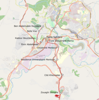
The tram system construction project was overseen by Pizzarotti, an Italian construction company. The tramway stretches for 15 km (9.3 mi) from a terminal in the Zouaghi District to the Ben-Abdelmalek Stadium station. The tramway runs from the city’s old-town alongside the main historical Mosque, passes over the slope of the Oued Rhumel, and proceeds through the university area, ending in the modern part of the city. The tramway has 21 stations, three of which are multi-modal (tram-bus-taxi), two viaducts of 465 metres (1,526 ft) and 114 metres (374 ft) in length, an underpass for urban traffic (with an open cutting 70 metres (230 ft) in length at the Emir Abdelkader Mosque), 12 supporting walls having an overall length of 1,185 metres (3,888 ft), a ground level depot (65,000 sq. m.) that guarantees the maintenance and parking of 27 trams.
See also
[edit]References
[edit]External links
[edit]- "Alstom delivered the first trainsets of the Constantine's Citadis tramway". Archived from the original on 29 November 2011.

