
Tyne and Wear Metro: Difference between revisions
GrouchoBot (talk | contribs) m robot Modifying: pt:Metropolitano de Newcastle |
|||
| Line 146: | Line 146: | ||
* Metro is one of the few systems where the names of people convicted to [[Fine (penalty)|fines]] for not paying their [[fare]] (''fare dodgers'' or ''losers'' as they were referred to as on the original signs) are shown on posters entitled "Named and Shamed" in the stations in a kind of shameful exposure somewhat comparable to the [[stocks]]. |
* Metro is one of the few systems where the names of people convicted to [[Fine (penalty)|fines]] for not paying their [[fare]] (''fare dodgers'' or ''losers'' as they were referred to as on the original signs) are shown on posters entitled "Named and Shamed" in the stations in a kind of shameful exposure somewhat comparable to the [[stocks]]. |
||
* The shortest distance between two stations is St. Peter's and Sunderland. The longest distance between two stations is Pelaw and Fellgate. |
* The shortest distance between two stations is between St. Peter's and Sunderland. The longest distance between two stations is between Pelaw and Fellgate. |
||
{{clear}} |
{{clear}} |
||
Revision as of 14:33, 3 May 2009
| Tyne and Wear Metro | |
|---|---|
| File:Tyne and Wear Metro logo.svg | |
| Overview | |
| Locale | Tyne and Wear |
| Stations | 60 |
| Service | |
| Type | Rapid transit/light rail/commuter rail |
| Services | Green line (Airport-South Hylton) Yellow line (St James-South Shields) |
| Operator(s) | Nexus |
| Depot(s) | South Gosforth |
| History | |
| Opened | 11 August 1980 |
| Technical | |
| Line length | 77.7 km (48.3 mi) |
| Operating speed | 80 km/h (50 mph) |
Tyne and Wear Metro | |||||||||||||||||||||||||||||||||||||||||||||||||||||||||||||||||||||||||||||||||||||||||||||||||||||||||||||||||||||||||||||||||||||||||||||||||||||||||||||||||||||||||||||||||||||||||||||||||||||||||||||||||||||||||||||||||||||||||||||||||||||||||||||||||||||||||||||||||||||||||||||||||||||||||||||||||||||||||||||||||||||||||||||||||||||||||||||||||||||||||||||||||||||||||||||||||||||||||||||||||||||||||||||||||||||||||||||||||||||||||||||||||||||||||||||||||||||||||||||||||||||||||||||||||||||||||||||||||
|---|---|---|---|---|---|---|---|---|---|---|---|---|---|---|---|---|---|---|---|---|---|---|---|---|---|---|---|---|---|---|---|---|---|---|---|---|---|---|---|---|---|---|---|---|---|---|---|---|---|---|---|---|---|---|---|---|---|---|---|---|---|---|---|---|---|---|---|---|---|---|---|---|---|---|---|---|---|---|---|---|---|---|---|---|---|---|---|---|---|---|---|---|---|---|---|---|---|---|---|---|---|---|---|---|---|---|---|---|---|---|---|---|---|---|---|---|---|---|---|---|---|---|---|---|---|---|---|---|---|---|---|---|---|---|---|---|---|---|---|---|---|---|---|---|---|---|---|---|---|---|---|---|---|---|---|---|---|---|---|---|---|---|---|---|---|---|---|---|---|---|---|---|---|---|---|---|---|---|---|---|---|---|---|---|---|---|---|---|---|---|---|---|---|---|---|---|---|---|---|---|---|---|---|---|---|---|---|---|---|---|---|---|---|---|---|---|---|---|---|---|---|---|---|---|---|---|---|---|---|---|---|---|---|---|---|---|---|---|---|---|---|---|---|---|---|---|---|---|---|---|---|---|---|---|---|---|---|---|---|---|---|---|---|---|---|---|---|---|---|---|---|---|---|---|---|---|---|---|---|---|---|---|---|---|---|---|---|---|---|---|---|---|---|---|---|---|---|---|---|---|---|---|---|---|---|---|---|---|---|---|---|---|---|---|---|---|---|---|---|---|---|---|---|---|---|---|---|---|---|---|---|---|---|---|---|---|---|---|---|---|---|---|---|---|---|---|---|---|---|---|---|---|---|---|---|---|---|---|---|---|---|---|---|---|---|---|---|---|---|---|---|---|---|---|---|---|---|---|---|---|---|---|---|---|---|---|---|---|---|---|---|---|---|---|---|---|---|---|---|---|---|---|---|---|---|---|---|---|---|---|---|---|---|---|---|---|---|---|---|---|---|---|---|---|---|---|---|---|---|---|---|---|---|---|---|---|---|---|---|---|---|---|---|---|---|---|---|---|---|---|---|---|---|---|---|---|---|---|---|---|---|---|---|---|---|---|---|---|---|---|---|---|---|---|---|---|---|---|---|---|---|---|---|---|---|---|---|---|---|---|---|---|---|---|---|---|---|---|---|---|---|---|---|---|---|---|---|---|---|---|---|---|---|
| |||||||||||||||||||||||||||||||||||||||||||||||||||||||||||||||||||||||||||||||||||||||||||||||||||||||||||||||||||||||||||||||||||||||||||||||||||||||||||||||||||||||||||||||||||||||||||||||||||||||||||||||||||||||||||||||||||||||||||||||||||||||||||||||||||||||||||||||||||||||||||||||||||||||||||||||||||||||||||||||||||||||||||||||||||||||||||||||||||||||||||||||||||||||||||||||||||||||||||||||||||||||||||||||||||||||||||||||||||||||||||||||||||||||||||||||||||||||||||||||||||||||||||||||||||||||||||||||||
The Tyne and Wear Metro, also known simply as the Metro, is a metro system serving stations in Newcastle upon Tyne, Gateshead, South Tyneside, North Tyneside and Sunderland, which are located in North East England. The network opened in 1980 and in 2006-2007 provided 39 million public journeys on its route of nearly 78 kilometres (48 mi).[1] It is operated by Nexus[2] and is one of only two underground metro-type systems in the UK outside London, the other being the Glasgow Subway, although Liverpool does have an underground too, though not very extensive (6 stations underground).
Overview
The Metro is usually described as Britain's first modern light rail system. However, it can be considered a hybrid system, displaying elements of light rail, heavy underground metro, and longer-distance, higher speed suburban and interurban railway systems.
The Metro began operating in 1980, but was an evolutionary development, as it was a pioneering system in the use of existing rights-of-way to create a modern rail transit system,[3] linking them with purpose-built tunnels under central Newcastle and Gateshead. Much of the Metro's route was part of one of the world's first electric urban railway systems, which opened in 1904 on public passenger lines that were then already well established (see Tyneside Electrics).[4] The Metro alignment comprises most of two of the world's oldest passenger railways, the Newcastle & North Shields Railway (Metro between Chillingham Road and North Shields) and the Brandling Junction Railway (between Gateshead and Monkwearmouth, near the Stadium of Light), both opened in 1839, making the Metro arguably one of the world's oldest local rail transport systems. In the case of Metro's Chichester station, the route of an existing mineral railway was chosen instead of the previous passenger railway alignment, as it passed through a more heavily populated area than the previous High Shields station, This is also the oldest section of the Metro route, dating back to 1834.
Changes
With the opening of the Sunderland extension in 2002,[5] the Metro became the first UK system to implement a form of the Karlsruhe model, using track shared with mainline trains on the section between Pelaw and Sunderland.[6] The section from Sunderland to South Hylton was previously part of the Sunderland to Durham mainline, closed in the wake of the Beeching Axe in the 1960s, and was the second Metro segment to be built on a completely disused line, following on from the Newcastle International Airport extension, which was largely built on the former Ponteland branch line.[7]
When the Metro first opened, it was claimed to be part of the UK's first integrated public transport system. The Metro was intended to cover trunk journeys, while buses were reoriented toward shorter local trips, tightly integrated with the Metro schedule, to bring passengers to and from the Metro stations, using unified ticketing. Much was made of the Metro's interchange stations such as Four Lane Ends and Regent Centre, which combined a large parking facility with a bus and Metro station;[8] this distinction is no longer emphasised. Some passengers complained that the Metro integration was pursued overzealously, and for example, bus passengers to Newcastle Upon Tyne would be forced to change to the Metro in Gateshead for a short trip, rather than have the bus route continue for a short distance further into Newcastle. Integration lasted until deregulation of bus routes in 1986. However, it is still possible to buy Transfare tickets that combine a Metro and bus journey.
News and issues
- In August 2008 The usage of mobility scooters on the Metro was banned permanently by operator Nexus.
- In July 2008 the UK Government awarded operator Nexus a £300 million commitment to modernise the Metro network in the Metro: All Change programme. More than £350 million will be spent in the next decade modernising stations, refurbishing trains and overhauling infrastructure including communications, track and overhead power lines, structures and embankments. Nexus will seek a further £300 million after 2019 when it plans to replace all trains and signal systems, alongside further modernisation.
- Metro is an 'open access' network with no mandatory ticket controls. Checks are made by roving patrols of inspectors. In September 2007 Nexus announced it was investing £14.3 million introducing new ticket machines, able to take credit/debit cards and notes alongside coins for the first time. At the same time it said three-quarter height barriers would be installed at 13 main stations from 2010.
- The Metro has been the subject of criticism from environmental campaigners as it does not permit the carriage of standard bicycles, though there are now storage lockers for these at some stations. Only small folding bicycles are now permitted on the Metro.
- The Metro long had a problem with fare evasion on the system, due to the lack of ticket inspectors on the trains. In recent years, the number of inspectors has increased, and in 2005 the penalty fare for travelling without a valid ticket was increased from £10 to £20.[9]
- Northumberland Park Metro station, costing a total of £5.7 million[10] opened on 11 December 2005 and serves a new housing development between Shiremoor and the A19 Holystone Interchange, including a 400-space multi-storey park-and-ride facility to be completed late 2008. It is located adjacent to existing track between Palmersville and Shiremoor on the northern loop section of the yellow line. It also acts as a feeder station for Nexus' R19 bus service, supporting Cobalt Business Park, the Silverlink Retail park, and North Shields.
- The "Stand clear of the doors please" announcement, which sounded before the doors started to close, was introduced in 1991. In 1996, a contest was held in which several mystery celebrities recorded the phrase, with a prize awarded for correct identification; these recordings were replaced by staff announcements after the contest ended. In order to increase the clarity of the announcement (especially for individuals not fluent in English) the phrase was replaced with "Doors closing" in 2004.
- In May 2007, an elderly woman on a mobility scooter entered the Metro on one side and crashed through the opposite doors falling onto the track at Jesmond Station.[1] Nexus stated that the doors had not been faulty and that this was the first occasion in 27 years that a set of doors had been forced open. There have since been two further incidents in similar circumstances and unaccompanied users of mobility scooters are no longer permitted on trains[2].
- On 17 October 2007 services were suspended between Benton and Shiremoor due to track subsidence to the east of Northumberland Park. This happened due to the collapse of a disused mineshaft near the station with services suspended for a number of days for remedial work to make the area safe. A full repair was completed in March 2008 by filling the shafts discovered with solid grouting.[11]
- The network's newest station, Simonside, opened on 17 March, 2008. It cost £3.2 million, partly funded by the European Regional Development Fund, and serves a large residential and commercial area in South Shields.
- On 3 November 2008 Nexus invited potential bidders to declare an interest in a contract to run the Operations side of the business on its behalf. The successful bidder will have a 7 year contract starting 1 April 2010, with up to an additional two years depending on performance. The contractor will be responsible for delivering the train service, fleet maintenance, day-to-day station management and the modernisation of 90 train cars.[12] In February 2009 four bids were shortlisted; DB Regio, MTR Corporation, Serco-NedRailways, and an in-house bid by Nexus.[13]
Rolling stock
The design of the Metrocars was partly derived from that of the German Stadtbahnwagen B, although the Metrocars were built by Metro-Cammell in Birmingham (now part of Alstom). Prior to opening, the Metro's two prototypes (numbered 4001 and 4002; they are still in service) underwent several years of testing at the Metro's own test track on North Tyneside, opened in 1975. The track was also used to test cars for the Hong Kong MTR, also built by Metro-Cammell. However, to accommodate the larger size of the Hong Kong cars, a short above ground test tunnel had to be demolished. The test track was built on the route of an old mineral wagonway, and it is now home to the Stephenson Railway Museum.
The Metro uses the line voltage of 1500 V DC, which was previously used on the Woodhead Line but is now unique in Britain. Metro has a rated top speed of 80 km/h (50 mph), which it attains on the rural stretches of the line. The vehicles have a minimum turning radius of 50 m (55 yd), although there are no curves this tight on the system, except for the non-passenger service chord between Manors and West Jesmond.[citation needed]
During the early years of Metro, cars were operated in single and double sets. As single set cars became overcrowded Nexus (operator of the system) resumed to using two cars as standard.[14] Single sets are used today, but only to operate the new Sunday service. Single cars became common during construction of the Sunderland extension when some units were taken for testing of the new track.


-
 Jesmond Station.
 -
 Monument Station, Central Newcastle.
 -
 The prototype Metro car, 4001, has been restored to its original livery (seen here at South Hylton in 2005).
 -
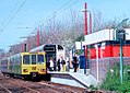 A Tyne & Wear Metro train heading for South Shields stopping at Kingston Park station.
 -
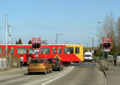 A Tyne & Wear Metro train shown crossing a level crossing.
 -
 Metro sign near Newcastle University.
 -
 Simonside Station, which opened in March 2008.
 -
 Four Lane Ends transport interchange.


Route
The Metro system currently consists of two lines:
- Green line - Newcastle Airport to South Hylton via Newcastle upon Tyne city centre, Gateshead, Sunderland city centre and continuing on to South Hylton.[15]
- Yellow line - St James to South Shields via North Shields, Tynemouth, Whitley Bay, then looping back on itself and going south via the city centre again to Gateshead, the Jarrow and South Shields.[16]
Originally there was also a Red line that ran between Pelaw and Benton, and a Blue line that ran between St James and North Shields. Additional trains ran on these lines during peak hours to increase the service frequency at the busier stations; they also made sense in the context of the extensions that were mooted at the time the Metro was opened. Many of these additional services still operate today, but are now considered Yellow line services.

Distances

Distances on the system are measured relative to a datum point at South Gosforth. The system is metric, with distances reported in km to the nearest m. Lines are designated as OUT and IN. The IN line is the line from St. James to South Shields via the inside of the loop (yellow line). The OUT line is the line from South Shields to St. James via the outside of the loop. By extension the IN line is also the line from Airport to South Gosforth, and onwards from Pelaw to Sunderland and South Hylton. Distance plates are mounted on all overhead line structures and these are used for references. Different distances are normally quoted for stations, depending upon whether the direction of travel is IN or OUT. Distances increase from the datum in all directions.[17]
The Sunderland extension, being Network Rail owned, uses the miles and chains system. The boundary between the two systems is close to Pelaw Metro Junction.[18]
Notable features

- The Tyne and Wear Metro was the first railway in the UK to operate using the metric system; all its speeds and distances are measured in metric units only.
- Smoking has been forbidden on the entire system since service began; this was one of the first comprehensive smoking bans.[19]
- A large-scale public artwork by Nayan Kulkarni, Nocturne, consisting of a moving kaleidoscope of light travelling along the Queen Elizabeth II Bridge (which carries the Metro between Newcastle and Gateshead) was inaugurated in April 2007.
- Wallsend station is probably the only public facility in Britain in which the signage is in Latin. Artist Michael Pinsky was commissioned to create the bilingual signs, along with a map of Hadrian's Wall in the style of the Metro map, to commemorate the area's Roman heritage and its location near the Segedunum Roman fort at the end of the wall. The project was part of Newcastle and Gateshead's unsuccessful joint bid to become European Capital of Culture in 2008.[20]
- Before tunnelling could begin, several disused mineshafts in Newcastle and Gateshead, some of them hundreds of years old, had to be completely filled in.
- Also before tunnelling under Newcastle could begin the disused Victoria Tunnel, which was used to transport coal under the city between 1842 - 1860, had to be investigated. However, not all of the tunnel remained, but any sections where required were strengthened to allow the metro tunnels to be dug above.
- Although the Metro opened in 1980, most of its route was previously part of one of the world's first electric suburban railways, which began service in 1904.
- The Metro incorporates almost all of two passenger railways that began operation in 1839: the Newcastle & North Shields Railway (Metro between Chillingham Road and North Shields), and the Brandling Junction Railway (Metro between Gateshead Stadium and Stadium of Light). Apart from engineering breaks, such as the time required for conversion to Metro, the two lines have been in continual use as passenger railways for over 165 years.
- The very oldest part of the Metro alignment has been in use for over 170 years — the section between the end of the tunnel approaching Tyne Dock and Chichester, which was part of the Stanhope & Tyne Railway, opened in 1834.
- The Metro is the first underground train network in the UK to install repeaters allowing customers to use their mobile phone in tunnels, an achievement that is being closely watched by the London Underground.
- The Metro pioneered the playing of classical music in some of its stations, which had a positive effect on reducing vandalism on the premises. In 2005 the London Underground began to follow the Metro's example.[21]

- For many years, the Metro was the only rapid-transit system in the world with a "pretzel" configuration in which a line crosses over itself and trains pass through the same station twice at different platforms, as yellow line trains do at Monument Station. It was joined by the Vancouver SkyTrain in Canada and the RandstadRail tram system in the Netherlands in 2006. Toronto had previously experimented with a pretzel configuration in 1966.[22]
- The Metro network employs a variant of the Karlsruhe model between Pelaw and Sunderland, which means it shares tracks with heavy rail freight and passenger services, so-called because of its initial use in the city of Karlsruhe where the city's trams operate on conventional railway lines.[23] Freight trains already used the Metro infrastructure from Bank Foot to Benton stations for the first decade of operations.
- Metro is one of the few systems where the names of people convicted to fines for not paying their fare (fare dodgers or losers as they were referred to as on the original signs) are shown on posters entitled "Named and Shamed" in the stations in a kind of shameful exposure somewhat comparable to the stocks.
- The shortest distance between two stations is between St. Peter's and Sunderland. The longest distance between two stations is between Pelaw and Fellgate.
Opening dates
| Year | From | To | Via |
|---|---|---|---|
| 11 August 1980 | Tynemouth | Haymarket | Whitley Bay, South Gosforth |
| 10 May 1981 | South Gosforth | Bank Foot | Fawdon |
| 15 November 1981 | Haymarket | Heworth | Monument |
| 14 November 1982 | St. James | Tynemouth | Monument, Wallsend and North Shields |
| 24 March 1984 | Heworth | South Shields | Pelaw, Jarrow |
| 15 September 1985 | Kingston Park | ||
| 16 September 1985 | Pelaw | ||
| 19 March 1986 | Palmersville | ||
| 17 November 1991 | Bank Foot | Newcastle Airport | |
| 31 March 2002 | Pelaw | South Hylton | Sunderland |
| 11 December 2005 | Newcastle Airport | South Hylton [24] | |
| 11 December 2005 | St. James | South Shields[25] | |
| 11 December 2005 | Northumberland Park | ||
| 17 March 2008 | Simonside |
Current issues
Timetable constraints
Since the opening of the Sunderland extension, Nexus found that the standard of service across the Metro network fell. This was mainly due to Network Rail stipulations requiring Metro services to be timetabled at least three minutes apart from the mainline trains at Pelaw and Sunderland. The stipulations mean that it is difficult for Metro services to run to a regular timetable.
As a result of the above, Nexus decided to reduce the number of mainline services between Sunderland and Newcastle from 36 per day to 22, this was effective from 11 December 2005. This allows Metro trains to run at evenly spaced 12-minute intervals throughout the day between Sunderland and Newcastle.
Poor patronage on Sunderland extension
The patronage on the section of the route between Park Lane and South Hylton has failed to meet targets. In 2004–2005 fewer than half the passengers predicted to use the service between these two points did so. In addition, passenger numbers have fallen on this section since 2003–2004. This has led Nexus to introduce a 50% reduction in services between Park Lane and South Hylton, again effective from December 2005. One possible reason for the lack of patronage is that there are only four stations on this section of route, therefore the vast majority of people living in Sunderland would have to first take a bus, then a Metro or mainline Train. The line also runs along the south bank of the River Wear, further limiting its catchment area. Park Lane's westbound platform is now used only for through trains to South Hylton. Those trains which terminate at Park Lane cross over onto the northbound platform for passengers to alight.
Corporate identity and livery
From the beginning, the Metro system employed a distinctive design and corporate identity, in part to distinguish itself from the decrepit rail system it replaced, but also to match the livery of the bus system then in use. The Calvert typeface, used for signage and in printed materials, was designed specifically for the Metro by Margaret Calvert. The corporate identity was revised in 1998, de-emphasising the Calvert font, and adding the word Metro to its M logo.
The Metro fleet was initially painted in a two-tone livery of cadmium yellow and white that matched the Metro station design of the time, as well as the livery of the Tyne and Wear bus fleet until 1986. In the mid-1990s a new colour scheme was introduced, with Metrocars painted solid red, green, or blue, with a yellow wedge at each end and yellow triangles on the doors. This scheme was modified slightly in 2005, in part to comply with safety regulations (the doors are now solid yellow to comply with the Disability Discrimination Act). In addition, many Metrocars have carried full-body advertising. The initial prototype (no. 4001) has been repainted in its initial yellow-and-beige livery (see image above)
The future

Haymarket Station renovation
Further plans call for Haymarket station in Newcastle city centre to be renovated as part of an overall improvement of the site; it will include leisure and retail facilities. Renovation started in 2007.[26]
Further coverage by the Metro
In 2002 Nexus unveiled an expansion plan that would extend the Metro system by adding new sections using street running, this changing the Metro into a high-end tram system. Nexus argued that this would provide a cost-effective way to introduce rail service to parts of Tyne and Wear the current Metro services did not reach. The plan listed a number of routes, not all of which were to be built as rail lines; transitional bus services were envisioned that could be replaced by trams as demand increased. However, the original Project Orpheus has been abandoned, possibly because of the government's present "value-for-money" policies for public transport. This increased scrutiny has affected expansion plans for other light-rail systems such as Manchester Metrolink, where an expansion scheme was halted even after construction had begun. Critics have said that Government policies now overtly favour bus schemes. A Metro link to Washington failed to gain Government backing, despite the existence of substantial railway rights of way to both Pelaw and Sunderland; preliminary support was offered only to a guided bus scheme.
Doubling of single-track section
Another project, to remove the last section of single track in the Metro system, between Pelaw and Bede, would cost around £12 million, and would allow freight trains to use the Metro infrastructure. Again, the Government has expressed doubts as to whether it considers this would be cost-effective. This however is included in a revised Project Orpheus. Along with the improvements to the current system, a Tyne and Wear Metro improvement and regeneration project is currently proposed with plans outlined in the Adobe external links document. As of 2005, there has been discussion of a public-private partnership to raise the funds necessary to modernise the Metro system.
Suggested extensions
- Current proposal
As of 2008, this is:
- Tyne Dock to East Boldon along one of two dismantled railway alignments could easily be added, as only a short distance lies between two Metro lines. This would provide a service from South Shields directly to Sunderland City Centre, via the Whiteleas area of South Shields. Originally suggested by the South Tyneside Local Development Framework and reported by local newspaper the Shields Gazette in January 2008.
- Previously proposed extensions
As of 2008, none of the following schemes is under current consideration:
- Washington, either via the disused Leamside Line or a new route. Present planning may lead to the Leamside Line being opened as a conventional passenger rail line instead. The government favours guided-bus service to Washington.
- Blyth & Ashington, running on existing little-used freight lines. Northumberland Park station is being built to provide a link to a potential new rail service to these communities; if opened, it will not be a part of the Metro system.
- Killingworth and Cramlington have been planned since Metro was on the drawing board, but would require widening of the busy East Coast main line to four tracks, which would be expensive, or a new alignment involving street running.
- The West End of Newcastle would require entirely new track involving tunneling and bridging in rough terrain; this would be very costly and is perhaps least likely to receive funding, though would probably have the highest potential ridership.
- Ryhope, in southern Sunderland, has been mooted as an extension using existing railway lines. This route is under criticism at present due to the further reduction in Northern Rail services that would likely have to follow.
- Seaham, a proposal was drawn up by Tyne and Wear Passenger Authority to extend Metro southbound to Seaham. The suggested connection to Seaham would run on a section of the existing Durham coast line, south of Sunderland.
External links
- Tyne and Wear Metro official website
- Nexus - Metro Operator home page
- TheTrams.co.uk Tyne and Wear Metro article
- Identifont - Characters of the Calvert font used on Metro signage
- Commissioning the Sunderland Direct extension in 2002
References
- ^ Length of the track Retrieved on 20 February 2007
- ^ "Who is Nexus?". Nexus. Retrieved 2008-05-31.
- ^ Modern Rail Transportation Retrieved on 20 February 2007
- ^ The Metro as the first public Rail Transportation Retrieved on 20 February 2007
- ^ May 2002 Sunderland Extension Retrieved on 20 February 2007
- ^ Light Rail and Main Line rail combined Retrieved on 20 February 2007
- ^ Extension to Newcastle Airport Retrieved on 20 February 2007
- ^ Combined of Stations and Bus services Retrieved on 20 February 2007
- ^ Increase in T&W Metro fares Retrieved on 20 February 2007
- ^ Cost of Northumberland Park Metro station Retrieved on 20 February 2007
- ^ Mine shaft collapse halts Metro Retrieved on 18 October 2007
- ^ "Bidders invited to register interest in Metro operations contract". Nexus. 2008-11-03. Retrieved 2008-11-03.
- ^ "Foreign bids for Metro contract". BBC News. 2009-02-02. Retrieved 2009-02-03.
- ^ Usage of single and double cars Retrieved on 20 February 2007
- ^ Route of Green Line trains Retrieved on 20 February 2007
- ^ Route of the Green Line Trains Retrieved on 20 February 2007
- ^ Maxey (Ed.), David (1987). Mile by Mile - Rail Mileages of Britain and Ireland. Peter Watts Publishing Limited, Woodchester, UK. ISBN 0 906025 44 3.
- ^ Jacobs (Ed.), Gerald (2006). Railway Track Diagrams Book 2: Eastern. Trackmaps, Bradford upon Avon. ISBN 0-9549866-2-8.
{{cite book}}: Cite has empty unknown parameter:|coauthors=(help) - ^ Smoking bans in Wallsend Retrieved on 20 February 2007
- ^ Michael Pinsky No smoking sign at Wallsend station Retrieved on 20 February 2007
- ^ Classical music in some of its Stations Retrieved on 20 February 2007
- ^ The crossing of Trains Retrieved on 20 February 2007
- ^ Karlsruhe Models usage on UK Railways Retrieved on 20 February 2007
- ^ History of Station openings Retrieved on 20 February 2007
- ^ History of Station openings Retrieved on 20 February 2007
- ^ Haymarket Metro stations plans Retrieved on 20 February 2007
See also
- Transport in Tyne and Wear
- List of rapid transit systems
- List of Tyne and Wear Metro stations
- London Underground
- Rail transport
- Dublin Metro
- Glasgow Subway
| Tramways |
| |||||||
|---|---|---|---|---|---|---|---|---|
| Metro |
| |||||||
| People mover | ||||||||
| Preserved | ||||||||