
Wikipedia:Graphics Lab/Map workshop: Difference between revisions
No edit summary |
|||
| Line 533: | Line 533: | ||
'''Article(s):''' [[Ages of consent in North America]] |
'''Article(s):''' [[Ages of consent in North America]] |
||
'''Request:''' A map of North America showing the ages of consent for each country. There's a map there, but it is seriously flawed, see the talk page of the article: [[Talk:Ages_of_consent_in_North_America#New_map]]. The sources are in the article, each country's |
'''Request:''' A map of North America showing the ages of consent for each country. There's a map there, but it is seriously flawed, see the talk page of the article: [[Talk:Ages_of_consent_in_North_America#New_map]]. The sources are in the article, each country's age of consent is presented there, with sources, for Mexico there is a table in its section. [[Special:Contributions/188.25.173.128|188.25.173.128]] ([[User talk:188.25.173.128|talk]]) 20:15, 8 March 2011 (UTC) |
||
Revision as of 20:19, 8 March 2011
The Graphics Lab is a project to improve the graphical content of the Wikimedia projects. Requests for image improvements can be added to the workshop pages: Illustrations, Photographs and Maps. For questions or suggestions one can use the talk pages: Talk:Graphics Lab, Talk:Illustrations, Talk:Photographs and Talk:Maps.
This specific page is the requests page for the Map workshop. Anyone can make a request for a map to be created or improved for a Wikipedia article. The standard format for making a request is shown below, along with general advice, and should be followed.
You are encouraged to share information and request advice from others. Also see possible conventions toolbox, map tutorials and topographic map tutorials.
| Advice to requesters |
|---|
|
What do we do?
|


| If you have completed work and not received a reply you may use the {{GL Map reply}} template to inform the requester. |
| Map makers and other visitors to the Graphics Lab may be interested in the RSS feed of changes to this page. You may find it here. |
| See also our sister Map workshop at Commons and the WikiProject Maps |
| Result | Code | Usage |
|---|---|---|
{{resolved|~~~~}}
|
Mark a thread as resolved and request archiving | |
{{subst:bump}}
|
Delay automatic archiving of a section for 30 days | |
{{I take|~~~~}}
|
When you'll be working on the request | |
{{Done}} ~~~~
|
When the request is done |
This page is automatically archived by ClueBot III. | |
| This page has a backlog that requires the attention of willing editors. Please remove this notice when the backlog is cleared. |
Axial Seamount
-
 Position of Axial Seamount on the Juan de Fuca ridge.

Article(s): Axial Seamount
Request: Cleanup, wikify, vectorize, crop the title at the top. Prospective GA. Thanks, ResMar 02:55, 11 October 2010 (UTC)
Graphist opinion(s): ![]() Done Jon Chui (talk) 02:55, 28 December 2010 (UTC)
Done Jon Chui (talk) 02:55, 28 December 2010 (UTC)
- Thanks: now I just need to find my source usb... :) ResMar 23:38, 28 December 2010 (UTC)

Bihar legislative assembly election, 2010
Article(s): Bihar legislative assembly election, 2010
-
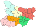 Attempt (please update/modify)

Request: Could someone please a make a map like this [1] from the one currently on the page? It seems the external one would be copyvio.
- Also, after the polls are announced on November 24 then wed need something like this. Thanks. Lihaas (talk) 13:37, 25 October 2010 (UTC)
Graphist opinion(s):
- Using the SVG that map file was derived from would be better. I find it a little odd that it's not just a clipped region from the SVG file. gringer (talk) 21:39, 25 October 2010 (UTC)
- Actually, on further observation, that map won't do. The administrative boundaries aren't detailed enough for the election boundaries. gringer (talk) 12:44, 26 October 2010 (UTC)
- To demonstrate that, I've extracted out the relevant portion of the locator map and coloured regions as close as possible to the boundaries in the external image (using 4-colour colours plus two more taken from the locator conventions). gringer (talk) 13:12, 26 October 2010 (UTC)
Iran–Bolivia relations

Article(s): Iran–Bolivia relations
Request: Need an introductory map akin to Iran - Ecuador relations. Thanks again for all your hard work.Lihaas (talk) 07:54, 28 October 2010 (UTC)
Graphist opinion(s):
![]() Done Wereldburger758 (talk) 06:29, 31 October 2010 (UTC)
Done Wereldburger758 (talk) 06:29, 31 October 2010 (UTC)
- Thanks.(Lihaas (talk) 10:38, 1 November 2010 (UTC));
Flag-map of the world
-
 Flag-map of the world
.svg)
Article(s): Quite a few
Request: In the small previews, only Southeast Asia and Australia are visible. I used the same method to make each country so I don't know the cause.
If it helps you to determine the cause, the versions of this file prior to October 2010 only have the US missing (they're outdated though). Transparent 6lue (talk) 22:50, 12 January 2011 (UTC)
Graphist opinion(s):
Veracruz, Mexican State
-
 Image A
 -
 Image B
 -
 Image C
 -
 Image D
 -
 Image E
 -
 Image F


Article(s): Veracruz and Municipalities of Veracruz and derivated articles for each city/municipality
Request: Hi I would like to have an image like Image D but for the State of Veracruz (ignoring the infobox in Image D). Actually my main concerns are:
- The size of Image A (2.05MB) when i see images like E (432KB) or F (123KB). If you could give me reduced version of this image I can do all the rest.
- Missing municipality on Image A and B: in Image B, the Municipality in darker blue is Playa Vicente (number 21 of Image C) which wrongly includes Santiago Sochiapan (number 22 Image C) within its borders, if it could be added to a reduced version of Image A, there is no need to create an image similar to Image D, i could take care of it.
Thank you very much. (Sorry to be repetitive, but just a reduced file size would make my day and I could start creating derivative maps after having it) EOZyo (мѕğ) 07:28, 16 January 2011 (UTC)
Graphist opinion(s):
- The size is in the details - image A contains polygons for all municipalities, which takes up much more data than just drawing all states of Mexico. Technically, a less precise version of A (i.e. one with less nooks and corners of all municipalities displayed) would suffice, but that's a lot of work. With a regular image, you could use graphical software to smooth the lines, but since every line is actually two edges of neighbouring municipalities, automatic smoothing gives unsatisfactory results... Sorry. Is the big file size a problem, though? Classical geographer (talk) 10:53, 20 January 2011 (UTC)
Rally Dakar
Article(s): 1979 Paris–Dakar Rally and others from Template:Dakar_Rally
Request:Hello, please create maps of all years Dakar Rally in same style like 2010 and 2011 (easy-translate SVG with all route). Sources are here [2] and here [3]. Thanks. Slfi (talk) 16:59, 17 January 2011 (UTC)
Graphist opinion(s): That's a lot of work, Slfi. Makes it worth your while to have a go yourself with Inkscape, maybe, if someone here provides you with a map showing France, Spain and NW-Africa? Classical geographer (talk) 10:49, 20 January 2011 (UTC)
Transilien P
Article(s): Transilien Paris – Est, Ligne P du transilien on the french wikipedia and the future article Transilien lijn P on the dutch wikipedia
Request: Could you make a map of line P of the transilien-network? Resources can be found here and here. Aliesperet (talk) 17:25, 19 January 2011 (UTC)
Graphist opinion:
- There is no map at all of any Transilien service. I think that would be a first priority; either a schematic map (as on the official Transilien website here) or one overlaid over a map of Paris - which would have the advantage of showing more clearly that Transilien services reach somewhat further out than the RER network. Aliesperet, what do you say? Classical geographer (talk) 10:45, 20 January 2011 (UTC)
Requester's Answer Than, if possible, an overlaid map which would have the advantage of showing more clearly that Transilien services reach somewhat further out than the RER network. — Preceding unsigned comment added by Aliesperet (talk • contribs) 20:13, 23 January 2011 (UTC)
Benghazi Map
-
 Map of the Mutamarat Shabiya (local divisions) within the Benghazi shabiya (top level national division).

Article(s): Benghazi
Request: Please vectorise the map and make it look nice.
Graphist opinion(s):
Jaw101ie (talk) 19:49, 20 January 2011 (UTC)
- Jaw101ie - I'm working on the map and will try to get it done in the next day. We're also working on improving OpenStreetMap coverage for Benghazi. [4] --Aude (talk) 17:15, 22 February 2011 (UTC)
Trinidad area code map
-
 a not-bad map of Trinidad
 -
an area-code map of Trinidad, drawn in crayons

Article(s): [[Area code 868
Request: This crayon-made version is an embarrassment. Can someone make a better one, please? DS (talk) 23:41, 26 January 2011 (UTC)
Graphist opinion(s): We'd need a source for the area code boundaries other than the crayon map to base a new one on. I did a very quick look and didn't see one. Kmusser (talk) 13:39, 29 January 2011 (UTC)
- Hm. If we don't have a source for the area code boundaries, should the image be deleted? DS (talk) 22:34, 27 February 2011 (UTC)
- If you want to, I see it's already been removed from the article. Kmusser (talk) 00:33, 28 February 2011 (UTC)
http://maps.google.pt/maps?f=q&source=s_q&hl=pt-PT&q=10.691803,-61.222503&aq=&sll=10.691803,-61.222503&sspn=2.628472,3.532104&ie=UTF8&hnear=Trindade+e+Tobago&lci=org.wikipedia.pt&rq=1&split=0&ll=11.636096,-60.985107&spn=2.619948,3.532104&z=8&iwloc=ltrends — Preceding unsigned comment added by Medeiros26 (talk • contribs) 20:43, 5 March 2011 (UTC)
Ü-Tsang

Article(s): Ü-Tsang
Request: It's interesting, but can we make it more encyclopedic? and png or svg?... Kintetsubuffalo (talk) 03:26, 28 January 2011 (UTC)
Graphist opinion(s):
Article(s): Terai
Request: Please create a map for the article (maybe similar to File:Indo-Gangetic Plain.png?)
WWF: Map of ecological divisions of Nepal, showing the Terai 78.55.207.248 (talk) 07:48, 1 February 2011 (UTC)
Graphist opinion:
United Kingdom Population density map
Article(s): United Kingdom
Request:I am here to ask you to please make a map showing the population density of the United Kingdom and its territories and crown dependencies. I two examples of the type of map in which I am referring to is the Spanish map- File:EspDens2.jpg and also the French map - File:France_population_density_40pc.png Thank You Rctycoplay (talk) 16:17, 7 February 2011 (UTC)
Graphist opinion:
Roman Empire map - needs correcting
-
 The map that needs to be corrected
 -
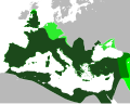 A map showing correct borders
.svg)

Article(s): Roman Empire
Request: In the orthographic projection, the Roman Empire's northern border (from the western edge of the Black Sea to the North Sea needs to be corrected. The northern border of Roman Britain also needs to be slightly adjusted. The second map shows the correct borders. The rest of the borders could also use some cleanup, so anything else that brings it closer to the second map would be appreciated. Swarm X 07:29, 8 February 2011 (UTC)
Graphist opinion(s):
Town of Bergen, New Jersey
Article(s): Bergen City, New Jersey
Request: I just added an 1868 legal boundry description to the Bergen City, New Jersey article of the no-longer-existing Town of Bergen, New Jersey. If you have time, please post a modern map with lines showing the boundary. Also, a map for Bergen Township, New Jersey (1893–1902) and Centre Township, New Jersey, please, using the legal boundry description posted there. Uzma Gamal (talk) 15:45, 8 February 2011 (UTC)
Graphist opinion(s):
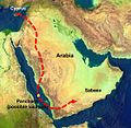
Historic map of Arabia
-
Arabia about 1923. Abdul Aziz's domain is in blue with dates of conquest. The Kingdom of the Hejaz, conquered in 1925, is in light green. (The other Hashemite kingdoms of Iraq and Transjordan are also in shades of green)
Article(s): Saudi Arabia,History of Saudi Arabia
Request: The labeling on the map is very small (and can't be read even in History of Saudi Arabia where it's 350px, can they be made bigger to be more readable? The only labels that need to be made bigger are the ones in the main blue area, the green area (labeled Hejaz) on Red sea coast, and the yellow area (labled upper Asir) in the bottom left. There seems to be plenty of space to do it. The other labels in the other areas are not relevant to the articles so can stay small. The other thing is there are dates under the label written in a strange way with year and month running into each other eg "192207". Can they be changed to eg "07/1922" or, preferably, if there is enough room "July 1922" DeCausa (talk) 09:15, 12 February 2011 (UTC)
Graphist opinion(s):
Battle of Wagram map(s)
-
 Helpful map of one of the stages of the battle.
 -
 This is a very detailed map of operations during the 2-day battle. It is overloaded with info, and would need to be broken down, according to the stages of the battle.
 -
 a basic map that could be used in making the requested map. It shows the basic geography of the battlefield.


Article(s): Battle of Wagram (Major expansion of the article to come).
Request: Create a few well-illustrated and catchy maps of the battle. Ideally, 4 maps would be needed (see below). Alexandru Demian (talk) 16:38, 12 February 2011 (UTC)
Hello, I am currently preparing a major expansion of the article about the battle of Wagram. I need a few well-illustrated and complete maps, such as the one you have made for the battle of Gebora. Ideally, four maps would be needed:
- 1. one map showing operations on 5 July: the French crossing of the Danube
- 2. one map showing operations on 5 July: the evening attacks.
- 3. one map showing the early operations on 6 July
- 4. one map showing the French attacks and Austrian retreat late on 6 July.
Some good maps are available here. There are also some very reliable and well illustrated maps of the battle in Ian Castle's "Aspern & Wagram 1809: Mighty Clash Of Empires".--Alexandru Demian (talk) 16:38, 12 February 2011 (UTC)
Graphist opinion:
Map of Masoala National Park
-
 The current, low-res map
 -
 Something similar to this might be nice
 -
 Here's the source
 -
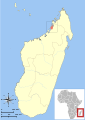 Another possibility


Article(s): Masoala National Park
Request: I would like to replace the low-res map on this article with something better. I recently rewrote Marojejy National Park and plan to eventually re-write this article as well. We clearly need a much better map. – VisionHolder « talk » 16:20, 17 February 2011 (UTC)
Graphist opinion(s):
Gateway Project
Article(s): Gateway Project
Request:
Would be great to have a detailed map of this planned new high speed rail corridor, info for which gives an idea... Djflem (talk) 00:27, 18 February 2011 (UTC)
Graphist opinion(s):
Map of USA with state names.svg needs a more detailed/robust font-family in source SVG
-
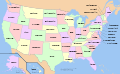 A compass of the United States, with state names.

Article(s): Political_divisions_of_the_United_States
Request: In the source of the file, replace:
font-family:Nimbus Sans L
with:
font-family:'Arial Narrow','Nimbus Sans L',sans-serif;"
This makes the source SVG map more readable where "Nimbus Sans L" is not installed. Tested on a local copy.
Graphist opinion(s): Made the font bold. What do you think about that? Wereldburger758 (talk) 07:18, 22 February 2011 (UTC)
Battle of Attock
-
 Style wished, other style ok too
Article(s): Battle of Attock
Request: Please create a proper battle map, I've uploaded tons of proper battle maps from military sources so I would appreciate it if someone could return the favor. Thank you Profitoftruth85 (talk) 02:19, 22 February 2011 (UTC)
Graphist opinion:
List of Sovereign states and dependent territories in Europe
-
 Guernsey png
 -
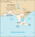
 Akrotiri and Dhekelia location on Cyprus map
 -
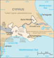
 Better Akrotiri
 -
 Better Dhekelia


Article(s): List of sovereign states and dependent territories in Europe
Request: Convert the Guernsey and Akrotiri and Dhekelia maps into svg's. Couple of other maps need editing for the article, but this would be a good first step. Thanks, Chipmunkdavis (talk) 15:09, 23 February 2011 (UTC)
Graphist opinion:
Iraqi Kurdish Civil War
-
 Please convert to svg

Article(s): Kurdistan Islamist Conflict, 2008 Turkish incursion into northern Iraq, Iraqi Kurdish Civil War
Request: DPlease convert to svg. P. S. Burton (talk) 15:31, 24 February 2011 (UTC)
Graphist opinion(s):
Old regions of Libya

Article(s): Cyrenaica, Tripolitania, Fezzan
Request: Please create English version of this file. Gryffindor (talk) 07:42, 27 February 2011 (UTC)
Graphist opinion(s):
Siege of Valencia
-
 Please redraw as svg.

Article(s): Siege of Valencia (1812)
Request: Please redraw as svg P. S. Burton (talk) 22:46, 1 March 2011 (UTC)
Graphist opinion(s):
Invasion of Anjouan
-
 Please redraw as svg, and ad an insert showing the islands position in relation to Africa.

Article(s): 2008 invasion of Anjouan
Request: Please redraw as svg, and ad an insert showing the islands position in relation to Africa. Thank. P. S. Burton (talk) 15:46, 2 March 2011 (UTC)
Graphist opinion(s): Note : there is the same request at the french atelier graphique. Bourrichon (talk) 16:45, 7 March 2011 (UTC)
Two maps for Myrrha
-

-
 Myrrha's flight route from her father.


Article(s): Myrrha
Request: I would really like these two maps to be in the same "design" (an SVG map could be cool, but I don't know if that's possible for this sort of map). If you could make two maps that show the routes plus borders of the countries in the early Ancient Greek world it would really be great. Please note that the location of the island Panchaea is up to you - it's a fictional island - but it is likely that those who told the myth of Myrrha imagined it to be around the place where I've put it. Please contact me, regards Mottenen (talk) 19:57, 6 March 2011 (UTC)
Graphist opinion(s):
Baltic Pipeline System-II
-
Description of image
-
2nd image (If there is one)
-
Don't request too many at once, though
Article(s): Baltic Pipeline System-II
Request: This article needs a proper map. Right now it uses scheme which bases on the template of railway line, and the pinpoint map showing pumping stations; however, these maps are ugly and not very user-friendly. The route map of the pipeline is shown at http://www.transneft.ru/objectdata/WebPageImpl/3658/74.gif. It could be also option to show Baltic Pipeline System and Baltic Pipeline System-II at the same map. Beagel (talk) 09:46, 8 March 2011 (UTC)
Graphist opinion(s):
Baltic Pipeline System
-
Description of image
-
2nd image (If there is one)
-
Don't request too many at once, though
Article(s): Baltic Pipeline System
Request: This article uses general map with a number of oil and gas pipelines in Russia. However, a pipeline specific map could be more apropriate. The specific map is at http://www.ecifpa.ru/content.asp?pn=318&lang=en It could be also option to show Baltic Pipeline System and Baltic Pipeline System-II at the same map. Beagel (talk) 09:55, 8 March 2011 (UTC)
Graphist opinion(s):
2009 Russia–Ukraine gas dispute
-
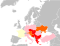 Countries of Europe gas supply to which was disrupted during Russia-Ukraine gas disputes in 2009

Article(s): 2009 Russia–Ukraine gas dispute
Request: The current map is incorrect as it shows incorrect data concerning several countries (e.g. Turkey, Ukraine). The correct map is located at http://ec.europa.eu/commission_2010-2014/president/news/documents/pdf/energy_en.pdf, page 7. I would like to ask to update the existing map accordingly. Beagel (talk) 10:12, 8 March 2011 (UTC)
Graphist opinion(s):
Ages of consent in North America
Article(s): Ages of consent in North America
Request: A map of North America showing the ages of consent for each country. There's a map there, but it is seriously flawed, see the talk page of the article: Talk:Ages_of_consent_in_North_America#New_map. The sources are in the article, each country's age of consent is presented there, with sources, for Mexico there is a table in its section. 188.25.173.128 (talk) 20:15, 8 March 2011 (UTC)