Renfrew County: Difference between revisions
.Units of measure |
added mention of Pembroke's independence |
||
| Line 39: | Line 39: | ||
<!-- Smaller parts (e.g. boroughs of a city) and seat of government --> |
<!-- Smaller parts (e.g. boroughs of a city) and seat of government --> |
||
|seat_type =[[County seat]] |
|seat_type =[[County seat]] |
||
|seat =[[Pembroke, Ontario|Pembroke]] |
|seat =[[Pembroke, Ontario|Pembroke]] (independent) |
||
|parts_type =Municipalities |
|parts_type =Municipalities |
||
|parts_style = <!-- =list (for list), coll (for collapsed list), para (for paragraph format) |
|parts_style = <!-- =list (for list), coll (for collapsed list), para (for paragraph format) |
||
| Line 107: | Line 107: | ||
==Government== |
==Government== |
||
The |
The seat of county government is in [[Pembroke, Ontario|Pembroke]], a city that is politically [[Independent city|independent]] of the county. In 2006, the county--along with Pembroke--was represented at the [[Canadian House of Commons]] as part of the riding of [[Renfrew—Nipissing—Pembroke]]. |
||
==Geography== |
==Geography== |
||
| Line 132: | Line 132: | ||
*Township of [[Whitewater Region, Ontario|Whitewater Region]] |
*Township of [[Whitewater Region, Ontario|Whitewater Region]] |
||
The |
The county seat, the city [[Pembroke, Ontario|Pembroke]], is politically [[Independent city|independent]]. |
||
==Original townships== |
==Original townships== |
||
Revision as of 02:39, 20 June 2011
- For the historic County of Renfrew in Scotland, see Renfrewshire.
Renfrew County | |
|---|---|
County | |
 The administration building of the county government | |
 Location of Renfrew County | |
| Country | |
| Province | |
| Established | 1861 |
| County seat | Pembroke (independent) |
| Municipalities | List
|
| Area | |
| • Land | 7,403.46 km2 (2,858.49 sq mi) |
| Population | |
| • Total | 97,545 |
| • Density | 13.2/km2 (34/sq mi) |
| Time zone | UTC-5 (EST) |
| • Summer (DST) | UTC-4 (EDT) |
| Area code(s) | 613 and 343 |
| Website | www.countyofrenfrew.on.ca/ |
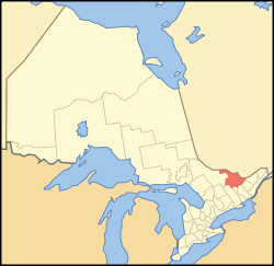
Renfrew is a county in the Canadian province of Ontario. In 2006, the population was 97,545 and county covered 7,403.46 square kilometres (2,858.49 sq mi), giving a population density of 34.2/sq mi (13.2/km2).[1] There are 17 official municipalities.
Government
The seat of county government is in Pembroke, a city that is politically independent of the county. In 2006, the county--along with Pembroke--was represented at the Canadian House of Commons as part of the riding of Renfrew—Nipissing—Pembroke.
Geography
Renfrew Country is known for its lakeside cottages and white-water rafting along the Ottawa River, and has more than 900 lakes.[2] It is located in the subregion of Southern Ontario named Eastern Ontario.
Municipalities
- Town of Arnprior
- Town of Deep River
- Town of Laurentian Hills
- Town of Petawawa
- Town of Renfrew
- Township of Admaston Bromley
- Township of Bonnechere Valley
- Township of Brudenell, Lyndoch and Raglan
- Township of Greater Madawaska
- Township of Head, Clara and Maria
- Township of Horton
- Township of Killaloe, Hagarty and Richards
- Township of Laurentian Valley
- Township of Madawaska Valley
- Township of McNab/Braeside
- Township of North Algona-Wilberforce
- Township of Whitewater Region
The county seat, the city Pembroke, is politically independent.
Original townships
- Admaston (Now part of Admaston Bromley)
- Alice (Now part of Laurentian Valley)
- Bagot (Now part of Greater Madawaska)
- Blythfield (Now part of Greater Madawaska)
- Bromley (Now part of Admaston Bromley)
- Brougham (Now part of Greater Madawaska)
- Brudenell (Now part of Brudenell, Lyndoch and Raglan)
- Buchanan (Now part of the Town of Laurentian Hills)
- Burns (Now part of Madawaska Valley)
- Clara (Now part of Head, Clara, and Maria)
- Fraser (Now part of Laurentian Valley)
- Grattan (Now part of Bonnechere Valley)
- Griffith (Now part of Greater Madawaska)
- Hagarty (Now part of Killaloe, Hagarty and Richards)
- Head (Now part of Head, Clara and Maria)
- Horton (Still exists)
- Jones (Now part of Madawaska Valley)
- Lyndoch (Now part of Brudenell, Lyndoch and Raglan)
- Maria (Now part of Head, Clara and Maria)
- Matawatchan (Now part of Greater Madawaska)
- McKay (Now part of the Town of Laurentian Hills]])
- McNab (Now McNab/Braeside)
- North Algona (Now part of North Algona-Wilberforce)
- Pembroke (Now part of Laurentian Valley)
- Petawawa (Now the Town of Petawawa)
- Radcliffe (Now part of Madawaska Valley)
- Raglan (Now part of Brudenell, Lyndoch and Raglan)
- Richards (Now part of Killaloe, Hagarty and Richards)
- Rolph (Now part of the Town of Laurentian Hills)
- Ross (Now part of Whitewater Region)
- Sebastopol (Now part of Bonnechere Valley)
- Sherwood (Now part of Madawaska Valley)
- South Algona (Now part of Bonnechere Valley)
- Stafford (Now part of Laurentian Valley)
- Westmeath (Now part of Whitewater Region)
- Wilberforce (Now part of North Algona-Wilberforce)
- Wylie (Now part of the Town of Laurentian Hills)
Arts and culture
At Wilno, Ontario Canada's Kashubian community celebrates their heritage.
Military
The county is home to CFB Petawawa and gives its name to The Lanark and Renfrew Scottish Regiment.
See also
References
- ^ a b c "Community highlights for Renfrew". 2006. Retrieved 2007-12-28.
- ^ Renfrew County, Ontario, Canada located in the Ottawa Valley, County of Renfrew
External links

