
Crimea: Difference between revisions
No edit summary |
|||
| Line 50: | Line 50: | ||
==History== |
==History== |
||
[[File:Crimean population in 18-21 centuries.jpg|thumb|right|upright|The demographic evolution of the Crimean peninsula during the last 3 centuries]] |
|||
[[File:Національний заповідник «Херсонес Таврійський» 2.jpg|thumb|left|upright|Ruins of [[Chersonesus]]]] |
[[File:Національний заповідник «Херсонес Таврійський» 2.jpg|thumb|left|upright|Ruins of [[Chersonesus]]]] |
||
[[File:Ласточкино гнездо.jpg|thumb|left|upright|[[Swallow's Nest]], built in 1912 for oil millionaire ''Baron von Steingel'', a [[landmark]] of Crimea]] |
[[File:Ласточкино гнездо.jpg|thumb|left|upright|[[Swallow's Nest]], built in 1912 for oil millionaire ''Baron von Steingel'', a [[landmark]] of Crimea]] |
||
Revision as of 14:10, 22 March 2014
This article documents a current event. Information may change rapidly as the event progresses, and initial news reports may be unreliable. The latest updates to this article may not reflect the most current information. |
45°18′N 34°24′E / 45.3°N 34.4°E
 | |
| Geography | |
|---|---|
| Location | Black Sea |
| Adjacent to | Black Sea Sea of Azov |
| Area | 27,000 km2 (10,000 sq mi) |
| Administration | |
| Demographics | |
| Demonym | Crimean |
| Population | 1,973,185 |
The Crimean peninsula (Ukrainian: Кримський півострів, Russian: Крымский полуостров, Crimean Tatar: Qırım yarımadası), also known as simply Crimea, is a major land mass on the northern coast of the Black Sea that is almost completely surrounded by water. The peninsula is located just south of the Ukrainian mainland and west of the Russian region of Kuban. It is surrounded by two seas: the Black Sea and the smaller Sea of Azov to the east. It is connected with the Ukrainian mainland by the Isthmus of Perekop and is separated from Kuban by the Strait of Kerch. The Arabat Spit is located to the northeast; a narrow strip of land that separates a system of lagoons named Sivash from the Sea of Azov.
Sovereignty over the peninsula is disputed between Ukraine and Russia. Under the Ukrainian Constitution, as recognized by international treaties, the peninsula is an integral part of Ukraine, consisting of the Autonomous Republic of Crimea (comprising most of the peninsula) and the city of Sevastopol in the southwest. Crimea and Sevastopol jointly declared themselves an independent state in March 2014 and after Crimean referendum on March 16, 2014, where 96.77% of voted people chose to join Russia, were admitted to Russia as federal subjects, called the Republic of Crimea and the federal city of Sevastopol. Ukraine and most of the international community do not recognize Russia's claim and consider the pro-Russian governments of Crimea and Sevastopol to be illegitimate.[2]
Virtually all of the peninsula is under de facto Russian control except of the upper part of the Arabat Spit which is administered by Ukraine as part of the Kherson region.
Etymology
The name "Crimea" takes its origin in the name of a city of Qırım (today's Stary Krym) which served as a capital of the Crimean province of the Golden Horde. Qırım is Crimean Tatar for "my hill" (qır "hill", -ım "my").[citation needed] Russian Krym is a Russified form of Qırım. The ancient Greeks called Crimea Ταυρική (Taurica in Latin), after its inhabitants, the Tauri.
History


The history of the Crimean peninsula covers more than 2,000 years, with many different conquerors and settlers throughout time. In ancient times, it was the home of Cimmerians and Scythians, as well as the site of Greek colonies. The most important city was Chersonesos at the edge of today's Sevastopol. Later occupiers included the Romans, Goths, Huns, Bulgars, Khazars, the state of Kievan Rus', the Byzantine Empire, the Kipchaks, and the Golden Horde. In the 13th century, portions were controlled by the Republic of Venice and by the Republic of Genoa.
The Crimean Khanate, a state ruled by Crimean Tatars and generally subject to the Ottoman Empire, succeeded the Golden Horde and lasted from 1441 to 1783. The Khanate was conquered by the Russian Empire under Catherine the Great in 1783. From 1853 to 1856, the peninsula was the site of the principal engagements of the Crimean War, a conflict fought between the Russian Empire and an alliance of the French Empire, the British Empire, the Ottoman Empire, the Kingdom of Sardinia, and the Duchy of Nassau.
During the Russian Civil War, Crimea was controlled by the White Army. After they were defeated by the Red Army, Crimea became part of the Soviet Union in 1921 as Crimean Autonomous Soviet Socialist Republic. In the Second World War the peninsula was occupied by Nazi Germany for several years.
In 1954, it was transferred to the Ukrainian Soviet Socialist Republic within the Soviet Union. In 1991, it became part of independent Ukraine.
Crimea was once again a site of conflict in 2014, when the region reacted negatively to the Euromaidan revolution in Kiev and came under Russian Federation control. Ukraine continues to claim Crimea as an integral part of its territory.
Geography
Crimea is located on the northern coast of the Black Sea and on the western coast of the Sea of Azov, bordering Kherson Oblast from the north. There are two rural communities of Henichesk Raion (Kherson Oblast) that are physically located on the peninsula, on the smaller peninsula Arabat Spit, Shchaslyvtseve and Strilkove. Although located in the southwestern part of the Crimean peninsula, the city of Sevastopol. Crimea is connected to the mainland by the 5–7 kilometres (3.1–4.3 mi) wide Isthmus of Perekop. At the eastern tip is the Kerch Peninsula, which is directly opposite the Taman Peninsula on the Russian mainland. Between the Kerch and Taman peninsulas, lies the 3–13 kilometres (1.9–8.1 mi) wide Strait of Kerch, which connects the waters of the Black Sea with the Sea of Azov. Peninsula consists of many other smaller peninsulas such as the mentioned Arabat Spit, Kerch peninsula, Herakles peninsula, Tarhan Qut peninsula and many others. Crimea also possesses lots of headlands such as Cape Priboiny, Cape Tarhan Qut,[citation needed] Sarych, Nicholas Cape, Cape Fonar, Cape Fiolent, Qazan Tip,[citation needed] Cape Aq Burun, and many others. Geographically, the peninsula is generally divided into three zones: steppes, mountains and southern coast. The southeast coast is flanked at a distance of 8–12 kilometres (5.0–7.5 mi) from the sea by a parallel range of mountains, the Crimean Mountains.[3] These mountains are backed by secondary parallel ranges. Seventy-five percent of the remaining area of Crimea consists of semiarid prairie lands, a southward continuation of the Pontic steppes, which slope gently to the northwest from the foot of the Crimean Mountains. The main range of these mountains shoots up with extraordinary abruptness from the deep floor of the Black Sea to an altitude of 600–750 metres (1,969–2,461 ft), beginning at the southwest point of the peninsula, called Cape Fiolente. It was believed that this cape was supposedly crowned with the temple of Artemis, where Iphigeneia is said to have officiated as priestess.[4] Uchan-su waterfall on the south slope of the mountains is the highest in Ukraine.
Numerous kurgans, or burial mounds, of the ancient Scythians are scattered across the Crimean steppes.
The terrain that lies beyond the sheltering Crimean Mountain range is of an altogether different character. Here, the narrow strip of coast and the slopes of the mountains are smothered with greenery. This "riviera" stretches along the southeast coast from capes Fiolente and Aya, in the south, to Feodosiya, and is studded with summer sea-bathing resorts such as Alupka, Yalta, Gurzuf, Alushta, Sudak, and Feodosiya. During the years of Soviet rule, the resorts and dachas of this coast served as the prime perquisites of the politically loyal.[citation needed]why here? and ref? In addition, vineyards and fruit orchards are located in the region. Fishing, mining, and the production of essential oils are also important. Numerous Crimean Tatar villages, mosques, monasteries, and palaces of the Russian imperial family and nobles are found here, as well as picturesque ancient Greek and medieval castles.
The Crimean coastline is broken by several bays and harbors. These harbors lie west of the Isthmus of Perekop by the Bay of Karkinit; on the southwest by the open Bay of Kalamita, with the ports of Eupatoria and Sevastopol;[citation needed](not Sevastopol) on the north by the Bay of Arabat of the Isthmus[citation needed](nonsense) of Yenikale or Kerch; and on the south by the Bay of Caffa[citation needed](name?) or Feodosiya, with the port of Feodosiya. The natural borders between Crimean peninsula and the Ukrainian mainland serves the saline Lake Syvash (a unique shallow system of estuaries and bays).
-
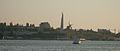 Coast of Sevastopol city at sunset
 -
 Eclizee-Burun Mountain
 -
 Yalta cliff
 -
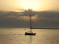 Sevastopol sunset
 -
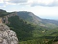 The Crimean Mountains near the city of Alushta
 -
Crimean Mountains


Climate
Most of Crimea has a temperate continental climate, except for the south coast where it experiences a humid[citation needed] subtropical climate, due to warm influences from the Black Sea and the high ground of the Crimean Mountains, which has a humid continental climate. Summers can be hot (28 °C (82.4 °F)* Jul average) and winters are cool (−0.3 °C (31.5 °F)* Jan average) in the interior, on the south coast winters are milder (4 °C (39.2 °F)* Jan average) and temperatures much below freezing are exceptional. On the high ground, freezing weather is common in winter. Precipitation throughout Crimea is low, averaging only 400 mm (15.7 in) a year. Because of its climate, the southern Crimean coast is a popular beach and sun resort for Ukrainian and Russian tourists.
References
- ^ http://rt.com/news/putin-include-crimea-sevastopol-russia-578/
- ^ "Putin signs Crimea treaty as Ukraine serviceman dies in attack". Reuters. 18 March 2014. Retrieved 19 March 2014.
- ^ The Crimean Mountains may also be referred to as the Yaylâ Dağ or Alpine Meadow Mountains.
- ^ See the article "Crimea" in the Encyclopædia Britannica Eleventh Edition.
