Kazemi Dam
Appearance
| Kazemi Bukan Dam | |
|---|---|
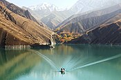
 Kazemi Dam from above | |
| Location | Bukan, Iran |
| Coordinates | 36°18′31.27″N 46°30′16.03″E / 36.3086861°N 46.5044528°E |
| Purpose | Power, irrigation |
| Status | Operational |
| Construction began | 1967 |
| Opening date | 1971 |
| Dam and spillways | |
| Type of dam | Dam with clay core |
| Impounds | Zarrineh River |
| Height | 50 m (164 ft) |
| Length | 720 m (2,362 ft) |
| Reservoir | |
| Total capacity | 800,000,000 m3 (648,571 acre⋅ft) |
| Power Station | |
| Installed capacity | 87 MW |
Kazemi Dam, Kazemi Bukan Dam (originally named Kourosh Dam) is a clay core dam on the Zarrineh River in the Zagros Mountains range, located near Bukan in Kurdistan Province, western Iran.[1][2]
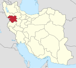
The crown of this dam is located 25 km Northeast of Bukan on the border of Kurdistan province and West Azarbaijan Province. The reservoir and lake of the dam are located in Kurdistan province and its catchment area is from Chehel Cheshmeh and Kileh Shin mountains in Zagros mountains between Saqqez and Baneh and Divandarreh.
This Dam was constructed to store water for supplying drinking water to cities, irrigation and produce hydroelectric power.[3]
See also
References
- ^ Conflict Resolution on Water Demands from Shahid Kazemi Reservoir by a Cooperative Game Theory, CIVILCA
- ^ Bukan Dam, Saqqezrudaw
- ^ Shahid Kazemi Dam, Islamic Azad University


