
North Pole

When not otherwise qualified, the term North Pole usually refers to the Geographic North Pole – the northernmost point on the surface of the Earth, where the Earth's axis of rotation intersects the Earth's surface. Other "North Poles" described in this article include:
- The North Magnetic Pole – the point on the Earth's surface where the Earth's magnetic field points directly downwards. This pole is constantly wandering; its estimated 2005 position was 82°42′N 114°24′W / 82.7°N 114.4°W [1].
- The North Geomagnetic Pole – the point of intersection of the Earth's surface with the axis of a simple magnetic dipole (like a bar magnet) that best approximates the Earth's actual more complex magnetic field. Like the North Magnetic Pole it constantly wanders; as of 2005 it was located at approximately 79°44′N 71°47′W / 79.74°N 71.78°W [2].
- The Northern Pole of Inaccessibility – the point in the Arctic Ocean farthest from land, at 84°03′N 174°51′W / 84.050°N 174.850°W.
- The North Celestial Pole – an imaginary point in the northern sky towards which the Earth's axis of rotation points.
Originally by analogy with the earth's magnetic field, the terms "north pole" and "south pole" are also applied to magnets in general, in order to distinguish one "end" of the magnet from the other. For this use see under Magnet and Magnetism.
Geographic North Pole
The Geographic North Pole (usually simply called the "North Pole") is, subject to the caveats explained below, defined as one of the two points where the Earth's axis of rotation meets the Earth's surface (the other being the South Pole, diametrically opposite). The Geographic North Pole defines latitude 90° North, as well as the direction of True North. At the North Pole all directions point south.
While the South Pole lies on a continental land mass, the North Pole is located in the middle of the Arctic Ocean. There is no land at the North Pole, just waters that are almost permanently covered with constantly shifting sea ice. This makes it impossible to construct a permanent station at the North Pole (unlike the South Pole).
Precise definition
The Earth's axis of rotation – and hence the position of the North Pole – was commonly believed to be fixed until, in the 18th century, the mathematician Leonhard Euler predicted that the axis might "wobble" slightly. Around the beginning of the 20th century astronomers noticed a small apparent "variation of latitude", as determined for a fixed point on Earth from the observation of stars. Part of this variation could be attributed to a wandering of the Pole, by a range of a few meters. The wandering has several periodic components and an irregular component. The component with a period of about 435 days is identified with the 8 month wandering predicted by Euler and is now called the Chandler wobble after its discoverer. This "wobble" means that a definition of the Pole based on the axis of rotation is not useful when more than about 1'' precision is required.
It is desirable to tie the system of Earth coordinates (latitude, longitude, and elevations or orography) to fixed landforms. Of course, given continental drift and the rising and falling of land due to volcanoes, erosion and so on, there is no system in which all geographic features are fixed. Yet the International Earth Rotation and Reference Systems Service and the International Astronomical Union have defined a framework called the International Terrestrial Reference System that does an admirable job. The North Pole of this system now defines geographic North for precision work, and it does not quite coincide with the rotation axis. See also polar motion.
Expeditions
- See also: Polar exploration and List of firsts
One of the earliest expeditions to set out with the explicit intention of reaching the North Pole was that of British naval officer William Edward Parry, who in 1827 reached latitude 82° 45' North. The Polaris expedition, an 1871 American attempt on the Pole led by Charles Francis Hall, ended in disaster. In April 1895 Norwegian Fridtjof Nansen reached latitude 86° 14´ North. The American explorer Frederick Albert Cook stated that he reached the North Pole in 1908, but his claim is not widely accepted.
The conquest of the North Pole is traditionally credited to Anglo-American Navy engineer Robert Edwin Peary, who claimed to have reached the Pole on April 6, 1909, accompanied by African-American Matthew Henson and four Inuit men named Ootah, Seeglo, Egigingwah, and Ooqueah. However, Peary's claim remains controversial. The party that accompanied Peary on the final stage of the journey included no one who was trained in navigation and could independently confirm his own navigational work, which some claim to have been particularly sloppy as he approached the Pole.
The distances and speeds that Peary claimed to have achieved once the last support party turned back border on the incredible, almost three times that which he had accomplished up to that point. Peary's account of a beeline journey to the Pole and back – the only strategy that might have allowed him to travel at such a speed – is contradicted by Henson's account of tortuous detours to avoid pressure ridges and open leads. But the controversy swung back in Peary's favour in 2005 when the British explorer Tom Avery and four companions recreated Peary's journey with replica wooden sleds and Canadian Eskimo Dog teams, reaching the North Pole in 36 days, 22 hours – nearly five hours faster than Peary. Avery writes on his web site that "The admiration and respect which I hold for Robert Peary, Matthew Henson and the four Inuit men who ventured North in 1909, has grown enormously since we set out from Cape Columbia. Having now seen for myself how he travelled across the pack ice, I am more convinced than ever that Peary did indeed discover the North Pole." (http://www.tomavery.net/gallery_np2005.html).
The first undisputed sighting of the Pole was on May 12 1926 by Norwegian explorer Roald Amundsen and his American sponsor Lincoln Ellsworth from the airship Norge. Norge, though Norwegian owned, was designed and piloted by the Italian Umberto Nobile. The flight started from Svalbard and crossed the icecap to Alaska. Nobile, along with several scientists and crew from the Norge, overflew the Pole a second time on May 24 1928 in the airship Italia.

Discounting Peary's disputed claim, the first men to set foot at the North Pole were, according to some sources, a Soviet Union party, including Pavel Gordiyenko and five others, who landed a plane there on 23 April 1948. [3] On May 3, 1952 U.S. Air Force Lieutenant Colonel Joseph O. Fletcher and Lieutenant William P. Benedict also landed a plane at the North Pole. Flying with them was scientist Albert P. Crary.
The United States Navy submarine USS Nautilus (SSN-571) crossed the North Pole on August 3, 1958, and on March 17, 1959, the USS Skate (SSN-578) surfaced at the pole, becoming the first naval vessel to reach it.
Ralph Plaisted made the first confirmed surface conquest of the North Pole on April 19, 1968. [clarification needed]
Sir Wally Herbert led the team that made the first surface crossing of the Arctic Ocean (1968-69) – and by its longest axis – a feat that has never been repeated. In so doing the team became the first to reach the North Pole by surface travel without the assistance of airlifts. In addition no one alive today has personally surveyed and mapped on the ground a larger area of Antarctica than Sir Wally. He has been awarded the Polar Medal and was knighted in 2000 for services to polar exploration.
The Soviet nuclear powered icebreaker Arktika completed the first surface vessel journey to the North Pole on August 17, 1977.
In 2005, the United States Navy submarine USS Charlotte (SSN-766) surfaced through 61 inches of ice at the North Pole and spent 18 hours there. [4]
Day and night
During the summer months, the North Pole experiences twenty-four hours of daylight daily but during the winter months the North Pole experiences twenty-four hours of darkness daily. Sunrise and sunset do not occur in a twenty-four hour cycle. At the North Pole, sunrise begins at the Vernal equinox taking three months for the sun to reach its highest point at the summer solstice when sunset begins, taking three months to reach sunset at the Autumnal equinox. A similar effect can be observed at the South Pole, with a six-month difference. This day/night effect is in stark contrast to what is observed at the Equator.
This effect is caused by a combination of the Earth's axial tilt and its revolution around the sun. The direction and angle of axial tilt of the Earth remains fairly constant (on a yearly basis) in its plane of revolution around the sun. Hence during the summer, the North Pole is always facing the sun's rays but during the winter, it always faces away from the sun.
Climate
The North Pole is significantly warmer than the South Pole because it lies at sea level in the middle of an ocean (which acts as a reservoir of heat), rather than at altitude in a continental land mass.
Winter (January) temperatures at the North Pole can range from about −43°C (−45ºF) to −26°C (−15°F), perhaps averaging around −34°C (−30ºF). Summer temperatures (June, July and August) average around the freezing point (0°C, 32°F). [5]
The sea ice at the North Pole is typically around two or three meters thick [6], though occasionally the movement of floes exposes clear water. Some studies have indicated that the average ice thickness has decreased in recent years due to global warming. [7] Reports have also predicted that within a few decades the Arctic Ocean will be entirely free of ice in the summer months. [8]
Territorial claims to the North Pole and Arctic regions
In 1925, based upon the Sector Principle, Canada became the first country to extend its boundaries northward to the North Pole, at least on paper, between 60°W and 141°W longitude, a claim that is not universally recognized (there is in fact 770 km of ocean between the Pole and Canada's therwise, until 1999, the North Pole and Arctic Ocean had been generally considered international territory. However, as the polar ice has begun to recede at a rate higher than expected (see global warming), several countries have made moves to claim, or to enforce pre-existing claims to, the waters or seabed at the Pole.
2001 Russian claim
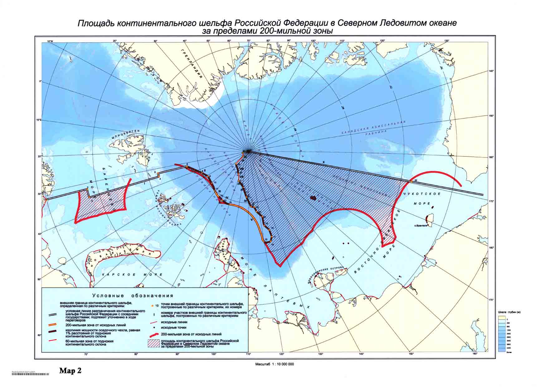
On December 20 2001 Russia made an official submission into the UN Commission on the Limits of the Continental Shelf in accordance with the United Nations Convention on the Law of the Sea (article 76, paragraph 8). In the document it is proposed to establish new outer limits of the continental shelf of Russia beyond the previous 200 mile zone, but within the Russian Arctic sector.[1] The territory claimed by Russia in the submission is a large portion of the Arctic, including the North Pole.[2] One of the arguments was a statement, that the underwater Lomonosov Ridge and Mendeleev Ridge are extensions of the Eurasian continent. In 2002 the UN Commission neither rejected, nor accepted the Russian proposal, recommending to carry out additional research.[1]
Other claims
This claim was contested by Norway, Canada, the United States and Denmark in 2004.[citation needed] The Danish autonomous province of Greenland has the nearest coastline to the North Pole, and Denmark argues that the Lomonosov Ridge is in fact an extension of Greenland. [citation needed]
The potential value of the North Pole and the surrounding area resides not so much in shipping but in the possibility that lucrative petroleum and natural gas reserves exist below the sea floor. Such reserves are known to exist under the Beaufort Sea, and further exploration elsewhere in the Arctic might become more feasible if global warming opens up the Northwest Passage as a regular channel of international shipping and commerce, particularly if Canada is not able to enforce its claim to it.
North Magnetic Pole
The North Magnetic Pole is the wandering point on the Earth's surface at which the Earth's magnetic field points vertically downwards (i.e. the "dip" is 90°). This definition was originally proposed in 1600 by Sir William Gilbert, a courtier of Queen Elizabeth I. The North Magnetic Pole should not be confused with the lesser known North Geomagnetic Pole.
For historical reasons, the "end" of a magnet that points towards the North Magnetic Pole is itself called the "north pole" of the magnet, with the other end being the magnet's "south pole". Because it is unlike poles that attract, the Earth's North Magnetic Pole is therefore actually a magnetic south pole. Because the Earth's magnetic field is not exactly symmetrical, the North and South Magnetic Poles are not antipodal: a line drawn from one to the other does not pass through the centre of the Earth (it actually misses by about 530 km).
Expeditions and measurements
The first expedition to reach the North Magnetic Pole was led by James Clark Ross, who found it at Cape Adelaide on the Boothia Peninsula on June 1, 1831. Roald Amundsen found Magnetic North in a slightly different location in 1903. The third observation of Magnetic North was by Canadian government scientists Paul Serson and Jack Clark, of the Dominion Astrophysical Observatory, who found the pole at Allen Lake on Prince of Wales Island.
The Canadian government has made several measurements since, which show that the North Magnetic Pole is continually moving northwest. In 1996 an expedition certified its location by magnetometer and theodolite at 78°35.7′N 104°11.9′W / 78.5950°N 104.1983°W. Its estimated 2005 position was 82°42′N 114°24′W / 82.7°N 114.4°W, to the west of Ellesmere Island, the biggest of the Queen Elizabeth Islands, in Canada [9]. During the 20th century it has moved 1100 km, and since 1970 its rate of motion has accelerated from 9 km/year to 41 km/year (2001-2003 average; see also Polar drift). If it maintains its present speed and direction it will reach Siberia in about 50 years, but it is expected to veer from its present course and slow down.
This movement is on top of a daily or diurnal variation in which Magnetic North describes a rough ellipse, with a maximum deviation of 80 km from its mean position. This effect is due to disturbances of the geomagnetic field by the sun.
Magnetic North and Magnetic Declination
- Main article: Magnetic declination. See also: Earth's magnetic field
The direction in which a compass needle points is known as magnetic north. In general, this is not exactly the direction of the North Magnetic Pole (or of any other consistent location). Instead, the compass aligns itself to the local geomagnetic field, which varies in a complex manner over the Earth's surface, as well as over time. The angular difference between magnetic north and true north (defined in reference to the Geographic North Pole), at any particular location on the Earth's surface, is called the magnetic declination. Most map coordinate systems are based on true north, and magnetic declination is often shown on map legends so that the direction of true north can be determined from north as indicated by a compass.
Magnetic declination has been measured in many countries, including the U.S. The line of zero declination in the U.S. runs from the North Magnetic Pole through Lake Superior and across the western panhandle of Florida. Along this line, true north is the same as magnetic north. West of the line of zero declination, a compass will give a reading that is east of true north. Conversely, east of the line of zero declination, a compass reading will be west of true north.
Magnetic declination is still very important for certain types of navigation that have traditionally made heavy use of the magnetic compass; see the main article (Magnetic declination) for details.
Geomagnetic reversal
Over geological timescales, the orientation of Earth's magnetic field (and that of other planets) can flip over, so that magnetic north becomes magnetic south and vice versa – an event known as a geomagnetic reversal. The Earth's magnetic field has done this repeatedly throughout history. It is thought that reversals occur when the circulation of liquid nickel/iron in the Earth's outer core is disrupted and then reestablishes itself in the opposite direction. It is not known what causes these disruptions. Evidence of geomagnetic reversals can be seen at mid-ocean ridges where tectonic plates move apart and the sea bed is filled in with magma. As the magma seeps out of the mantle the magnetic particles contained within it are oriented in the direction of the magnetic field at the time.
North Geomagnetic Pole
As a first-order approximation, the Earth's magnetic field can be modelled as a simple dipole (like a bar magnet), tilted about 11° with respect to the Earth's rotation axis and centered at the Earth's centre. The residuals form the nondipole field. The North and South Geomagnetic Poles are the antipodal points where the axis of this theoretical dipole intersects the Earth's surface. If the Earth's magnetic field were a perfect dipole then the field lines would be vertical at the Geomagnetic Poles, and they would therefore coincide with the Magnetic Poles (see above). However, the approximation is in fact far from perfect, so in reality the Magnetic and Geomagnetic Poles lie some distance apart.
Like the North Magnetic Pole, the North Geomagnetic Pole attracts the north pole of a bar magnet and so is actually a south magnetic pole. It is the centre of the region of the magnetosphere in which the Aurora Borealis can be seen. As of 2005 it was located at approximately 79°40′N 71°47′W / 79.66°N 71.78°W, off the northwest coast of Greenland [10], but it is now drifting away from North America and toward Siberia. The first voyage to this Pole was by David Hempleman-Adams in 1992.
Northern Pole of Inaccessibility
The Northern Pole of Inaccessibility, located at 84°03′N 174°51′W / 84.050°N 174.850°W, is the point in the Arctic Ocean farthest from land. It lies about 1100 km from the nearest coast, and is a geographic construct, not an actual physical phenomenon. It was first reached by Sir Hubert Wilkins, who flew by aircraft in 1927; in 1958 a Russian icebreaker reached this point.
Cultural references to the North Pole
In many versions of the Santa Claus mythos, the North Pole is the place where Santa Claus lives.
In many stories, the North Pole is the place where the gateway to an underground world lies.
Defining North Poles in astronomy
The International Astronomical Union defines the geographic north pole of a planet or other object in the solar system as the planetary pole that is in the same ecliptic hemisphere as the Earth's North Pole. More accurately, "The north pole is that pole of rotation that lies on the north side of the invariable plane of the solar system" [11]. This definition means that an object's axial tilt is always 90° or less, but its rotation period may be negative (retrograde rotation) – in other words, it rotates clockwise when viewed from above its north pole, rather than the "normal" counterclockwise direction exhibited by the Earth.
Another common definition uses the right-hand rule to define an object's north pole: it is then the pole around which the object rotates counterclockwise [12]. With this definition, axial tilts may be greater than 90° but rotation periods are always positive.
The projection of a planet's geographic north pole onto the celestial sphere gives its north celestial pole.
Some bodies in the solar system, including Saturn's moon Hyperion and the asteroid 4179 Toutatis, lack a stable geographic north pole. They rotate chaotically because of their irregular shape and gravitational influences from nearby planets and moons, and as a result the instantaneous pole wanders over their surface, and may momentarily vanish altogether (when the object comes to a standstill with respect to the distant stars).
Planetary magnetic poles are defined analogously to the Earth's magnetic poles: they are the locations on the planet's surface at which the planet's magnetic field lines are vertical. The direction of the field determines whether the pole is a magnetic north or south pole, exactly as on Earth. The Earth's magnetic axis is orientated in approximately the same direction as its rotational axis, meaning that the magnetic poles are reasonably close to the geographic poles. However, this is not necessarily the case for other planets; the magnetic axis of Uranus, for example, is inclined by as much as 60°.
In the particular (but frequent) case of synchronous satellites, four more poles can be defined. They are the near, far, leading, and trailing poles. Take Io for example; this moon of Jupiter rotates synchronously, so its orientation with respect to Jupiter stays constant. There will be a single, unmoving point of its surface where Jupiter is at the zenith, exactly overhead — this is the near pole, also called the sub- or pro-Jovian point. At the antipode of this point is the far pole, where Jupiter lies at the nadir; it is also called the anti-Jovian point. There will also be a single unmoving point which is furthest along Io's orbit (best defined as the point most removed from the plane formed by the north-south and near-far axes, on the leading side) —this is the leading pole. At its antipode lies the trailing pole. Io can thus be divided into north and south hemispheres, into pro- and anti-Jovian hemispheres, and into leading and trailing hemispheres. Note that these poles are mean poles because the points are not, strictly speaking, unmoving: there is constant jiggling about the mean orientation, because Io's orbit is slightly eccentric and the gravity of the other moons disturbs it regularly.
See also
- South Pole
- Polaris
- Arctic Ocean
- List of firsts
- Inuit Circumpolar Conference
- Arctic Council
- Circumpolar arctic
- Biomes
- North Pole, Alaska
References
- ^ a b Outer limits of the continental shelf beyond 200 nautical miles from the baselines: Submissions to the Commission: Submission by the Russian Federation CLCS. United Nations
- ^ Area of the continental shelf of the Russian Federation in the Arctic Ocean beyond 200-nautical-mile zone - borders of the 200 mile zone are marked in red, territory claimed by Russia is shaded
External links
- Arctic Council
- The Northern Forum
- Template:Wikitravel
- North Pole Web Cam
- The short Arctic summer of 2004
- The puzzling Arctic summer of 2003
- FAQ on the Arctic and the North Pole
- Polar Controversies Still Rage article by Roderick Eime
- Magnetic Poles locations since 1600 Download the KMZ file. For Google Earth Users.
- The Polar Race a biennial race to the 1996 certified position of the Magnetic North Pole
- The Polar Challenge an annual race to the Magnetic North Pole
- Template:Confluence
- Daylight, Darkness and Changing of the Seasons at the North Pole
- Video of scientists on sea ice at the North Pole as it begins to crack underfoot
- Experts warn North Pole will be 'ice free' by 2040
- Goudarzi, Sara, "Meltdown: Ice Cracks at North Pole". Sept 2006, LiveScience, <Web Link>, Accessed 29 Jan. 2007.