Haraiki
 NASA picture of Haraiki Atoll | |
| Geography | |
|---|---|
| Location | Pacific Ocean |
| Coordinates | 17°28′S 143°28′W / 17.467°S 143.467°W |
| Archipelago | Tuamotus |
| Area | 10.4 km2 (4.0 sq mi) (lagoon) 4 km2 (1.5 sq mi) (above water) |
| Length | 7 km (4.3 mi) |
| Width | 5 km (3.1 mi) |
| Administration | |
France | |
| Overseas collectivity | French Polynesia |
| Administrative subdivision | Tuamotus |
| Commune | Makemo |
| Demographics | |
| Population | Uninhabited[1] (2012) |
Haraiki[2] is a small atoll of the Tuamotu Archipelago in French Polynesia. It is located 42 km southwest of Marutea Nord.
Haraiki Atoll is roughly triangular in shape. It measures 7 km in length with a maximum width of 5 km. There are three islets on its reef with a total land area of about 4 km2. Its lagoon has a pass facing south.
Haraiki is purportedly uninhabited. However, Google Maps reveals there is a small collection of buildings on the north shore (-17.446343,-143.455739) and that the bulk of the land on all three islets has been heavily planted with a grid-like patchwork of trees or large shrubs.
History
[edit]The first recorded European to sight Haraiki Atoll was Spanish navigator Domingo de Boenechea on October 31, 1772, on ship Aguila. He named this atoll "San Quintín".[3][4]
Administration
[edit]
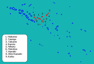
Haraiki belongs to the commune of Makemo, which consists of the atolls of Makemo, Haraiki, Marutea Nord, Katiu, Tuanake, Hiti, Tepoto Sud, Raroia, Takume, Taenga and Nihiru.

References
[edit]- ^ "Population". Institut de la statistique de la Polynésie française. Archived from the original on 29 March 2020. Retrieved 26 September 2014.
- ^ Young, J.L. (1899). "Names of the Paumotu Islands, with the old names so far as they are known". Journal of the Polynesian Society. 8 (4): 264–268. Archived from the original on 10 February 2012. Retrieved 7 January 2015.
- ^ Robson, R.W. The Pacific Islands Handbook New York, 1946, p.94
- ^ Salmond, Anne (2010). Aphrodite's Island. Berkeley: University of California Press. pp. 241. ISBN 9780520261143.
External links
[edit]- Atoll list (in French) Archived 2007-02-28 at the Wayback Machine

