
Wakayama Prefecture
Template:Infobox Prefecture Japan

Wakayama Prefecture (和歌山県, Wakayama-ken) is a prefecture of Japan located on the Kii Peninsula in the Kansai region on Honshū island. The capital is the city of Wakayama.
History
Present-day Wakayama is mostly the western part of the province of Kii.
Geography
Cities
Nine cities are located in Wakayama Prefecture:
Towns and villages
These are the towns and villages in each district:
Mergers
Economy
Wakayama supplies most of Japan with its high production of mikans (Mandarin Oranges) in October of every year.
Demographics
Culture
Mount Kōya (高野山, Kōya-san) in the Ito District is the headquarters of the Shingon sect of Japanese Buddhism. It is home to one of the first Japanese style buddhist temples in Japan and remains a site of pilgrimage and an increasingly popular tourist destination as people flock to see its ancient temples set amidst the towering cedar trees at the top of the mountain.
The Kumano Shrines are located on the southern tip of the prefecture.
Sister relationships
Wakayama Prefecture has friendship and sister relationships with six places outside Japan[1]. These are Richmond, Canada; Shandong, People's Republic of China; Pyrénées-Orientales, France; Florida, United States; Sinaloa, Mexico; and Galicia, Spain.
Tourism
-
 Prefecture outline
 -
 Saikazaki, Wakanoura
 -

-
 The Museum of Modern Art, Wakayama
 -
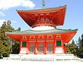 Konpon Daido
(Mount Koya) -

-
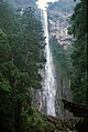 Nachi waterfall
 -
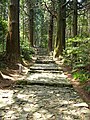 Daimonzaka
(Kumano Kodō)


References
External links
- Official Wakayama Prefecture homepage
- Wakayama Tourist Guide
- Nanki Sightseeing Guide
- Tanabe City Kumano Tourism Bureau
| Core city |  | |
|---|---|---|
| Cities | ||
| Districts | ||
