
Geology of Mars
 Mars as seen by the Hubble Space Telescope | |||||||||||||
| Designations | |||||||||||||
|---|---|---|---|---|---|---|---|---|---|---|---|---|---|
| Adjectives | Martian | ||||||||||||
| Symbol | |||||||||||||
| Orbital characteristics[1] | |||||||||||||
| Epoch J2000 | |||||||||||||
| Aphelion | 249,209,300 km 1.665861 AU | ||||||||||||
| Perihelion | 206,669,000 km 1.381497 AU | ||||||||||||
| 227,939,100 km 1.523679 AU | |||||||||||||
| Eccentricity | 0.093315 | ||||||||||||
| 686.971 day 1.8808 Julian years | |||||||||||||
| 779.96 day 2.135 Julian years | |||||||||||||
Average orbital speed | 24.077 km/s | ||||||||||||
| Inclination | 1.850° 5.65° to Sun's Equator | ||||||||||||
| 49.562° | |||||||||||||
| 286.537° | |||||||||||||
| Known satellites | 2 | ||||||||||||
| Physical characteristics | |||||||||||||
Equatorial radius | 3,396.2 ± 0.1 km[a][2] 0.533 Earths | ||||||||||||
Polar radius | 3,376.2 ± 0.1 km[a][2] 0.531 Earths | ||||||||||||
| Flattening | 0.00589 ± 0.00015 | ||||||||||||
| 144,798,500 km² 0.284 Earths | |||||||||||||
| Volume | 1.6318×10¹¹ km³ 0.151 Earths | ||||||||||||
| Mass | 6.4185×10²³ kg 0.107 Earths | ||||||||||||
Mean density | 3.934 g/cm³ | ||||||||||||
| 3.69 m/s² 0.376 g | |||||||||||||
| 5.027 km/s | |||||||||||||
| 1.025957 day 24.62296 h[3] | |||||||||||||
Equatorial rotation velocity | 868.22 km/h | ||||||||||||
| 25.19° | |||||||||||||
North pole right ascension | 21 h 10 min 44 s 317.68143° | ||||||||||||
North pole declination | 52.88650° | ||||||||||||
| Albedo | 0.15[4] | ||||||||||||
| |||||||||||||
| +1.8 to −2.91[4] | |||||||||||||
| 3.5" — 25.1"[4] | |||||||||||||
| Atmosphere | |||||||||||||
Surface pressure | 0.7–0.9 kPa | ||||||||||||
| Composition by volume | 95.72% Carbon dioxide 2.7% Nitrogen | ||||||||||||
The geology of Mars, also known as areology (from Greek Ἂρης Arēs and -λογία -logia), refers to the study of the composition, structure, physical properties, history, and the processes that shape the planet Mars.
Elemental composition
This section needs expansion. You can help by adding to it. (December 2008) |
Elements present on Mars include among others oxygen (O), iron (Fe), and silicon (Si), along with significant amounts of magnesium (Mg), aluminum (Al), sulfur (S), calcium (Ca) and titanium (Ti). The planet's distinctive red coloration is largely due to the oxidation of its surface iron. Recently Mars soil was found to contain ice trapped in minerals. It was also found to contain potassium (K), chlorine (Cl) and sodium (Na).[5]
Scientists have learned about the elemental composition of Mars from several sources. A number of space probes have landed on the planet; some were able to move around. The Viking program was the first to land two robots on Mars. The Pathfinder mission included Sojourner rover which analyzed rocks, as well as the soil. The Phoenix lander landed very far to the North. Two Mars Exploration Rovers have been crawling on the Martian surface for over 5 years so far. These probes carried instruments that analyzed the surface. We also have many actual samples of Mars in the form of meteorites that have made their way to Earth. These meteorites are called SNC's, for Shergottites meteorites, Nakhla meteorite, Chassigny meteorite.[6] Some orbiting space craft have instruments that can actually map the distribution of some chemicals.
Timeline
Crater density timeline
Studies of impact crater densities on the Martian surface allow us to identify three broad epochs in the planet's geological timescale, as older surfaces have many craters and younger ones have few.[7] The epochs were named after places on Mars that belong to those time periods. The precise timing of these periods is not known because there are several competing models describing the rate of meteor fall on Mars, so the dates given here are approximate. From oldest to youngest, the time periods are:
- Noachian epoch (named after Noachis Terra): Formation of the oldest extant surfaces of Mars between 4.6 and 3.5 billion years ago. Noachian age surfaces are scarred by many large impact craters. The Tharsis bulge is thought to have formed during this period, with extensive flooding by liquid water late in the epoch.
- Hesperian epoch (named after Hesperia Planum): 3.5 to 1.8 Ga BP. The Hesperian epoch is marked by the formation of extensive lava plains. Formation of Olympus Mons likely began during this epoch[8].
- Amazonian epoch (named after Amazonis Planitia): 1.8 Ga BP to present. Amazonian regions have few meteorite impact craters but are otherwise quite varied. Lava flows on Mars continued during this period.

The studying of craters is based upon the assumption that crater-forming impactors have hit the planet all throughout history at regular intervals, and there is no way to exactly date an area just based upon the number of impacts, only to guess that areas with more impacts must be older than areas with fewer impacts. For example this logic breaks down if a large number of asteroids had hit at once, or if there were long periods where few asteroids hit.
Mineralogical timeline
Based on recent observations made by the OMEGA Visible and Infrared Mineralogical Mapping Spectrometer on board the Mars Express orbiter, the principal investigator of the OMEGA spectrometer has proposed an alternative timeline based upon the correlation between the mineralogy and geology of the planet. This proposed timeline divides the history of the planet into 3 epochs; the Phyllocian, Theiikian and Siderikan.[9][10]
- Phyllocian (named after the clay-rich phyllosilicate minerals that characterize the epoch) lasted from the formation of the planet until around 4000 million years ago. In order for the phyllosilicates to form an alkaline water environment would have been present. It is thought that deposits from this era are the best candidates to search for evidence of past life on the planet. The equivalent on Earth is much of the hadean eon.
- Theiikian (named, in Greek, after the sulfate minerals that were formed), lasting until about 3500 million years ago, was a period of volcanic activity. In addition to lava, gasses - and in particular sulfur dioxide - were released, combining with water to create sulfates and an acidic environment. The equivalent on Earth is the eoarchean era and the beginning of the paleoarchean era.
- Siderikan, from 3500 million years ago until the present. With the end of volcanism and the absence of liquid water, the most notable geological process has been the oxidation of the iron-rich rocks by atmospheric peroxides, leading to the red iron oxides that give the planet its familiar color. The equivalent on Earth is most of the archean all of the proterozoic and up to now.

Minerals
Today, scientists are quite confident about what minerals exist on the Red Planet. There is strong evidence that olivine, pyroxene, feldspar, hematite, clay, goethite, jarosite, iron sulfates, and opaline silica exist on Mars.
Mars, like the Earth has long been thought to be covered with a great deal of the volcanic rock basalt. Appropriately, minerals derived from this rock are found on the surface. Olivine, pyroxene, and feldspar result from the simple mechanical break down of basalt. Many other minerals were formed from the interaction of basalt with water. Clay, also known as phyllosilicate, occurs only after long exposure to water. [11]

Spectra from the NASA THEMIS probe have shown the possibility of the mineral olivine on Mars by looking for the characteristic infra-red radiation it emits. The discovery is interesting because the mineral, which is associated with volcanic activity, is very susceptible to weathering by water, and so its presence and distribution which can be obtained from satellite could tell us about the history of water on Mars.
Olivine forms from magma and weathers into clays or iron oxide. The researchers found olivine all over the planet, but the largest exposure was in Nili Fossae, a region dating from >3.5 Ga (the Noachian epoch). Another outcrop is in the Ganges Chasma, an eastern side chasm of the Valles Marineris (pictured).[12]
Opaline silica and iron sulfates form in acid solutions, so parts of Mars may have had lakes of acid. These two minerals have been found in a variety of locations, including near Juventae Chasma, Ius Chasma, Melas Chasma, Candor Chasma, and Ganges Chasma. These sites all contain valleys or channels indicating abundant water. [13] [14]
Positive identification of Martian minerals were made with orbiting space craft like the Mars Reconnaissance Orbiter, as well as with two rovers on the surface--Spirit Rover and Opportunity Rover. Examination of a variety of meteorites from Mars has also yielded knowledge of the minerals on Mars. [15]
Detecting and mapping minerals on Mars are important for the search for life. Life may not be found with the mineral olivine because olivine would not last long around water. On the other hand, sulfate deposits preserve chemical and morphological fossils; iron oxides (like hematite) can even form fossils of microorganisms. [16] The presence of silica deposits (like opaline silica) points toward a hydrothermal environment that could support life. silica is also excellent for preserving evidence of microbes. [17]
Surface chemistry

The surface of Mars is thought to be primarily composed of basalt, based upon the observed lava flows from volcanos, the Martian meteorite collection, and data from landers and orbital observations. The lava flows from Martian volcanos show that lava has a very low viscosity, typical of basalt.[18] Analysis of the soil samples collected by the Viking landers in 1976 indicate iron-rich clays consistent with weathering of basaltic rocks.[18] There is some evidence that some portion of the Martian surface might be more silica-rich than typical basalt, perhaps similar to andesitic rocks on Earth, though these observations may also be explained by silica glass, phyllosilicates, or opal. Much of the surface is deeply covered by dust as fine as talcum powder. The red/orange appearance of Mars' surface is caused by iron(III) oxide (Fe2O3) (rust).[19] Mars has twice as much iron oxide in its outer layer as Earth does, despite their supposed similar origin. It is thought that Earth, being hotter, transported much of the iron downwards in the 1,800 km deep, 3,200 °C, lava seas of the early planet, while Mars, with a lower lava temperature of 2,200 °C was too cool for this to happen.[19] While the possibility of carbonates on Mars has been of great interest to exobiologists and geochemists alike, there is little evidence for significant quantities of carbonate deposits on the surface.
One of the goals of potential NASA missions to the planet is to grow plants such as asparagus, green beans and turnips in the Martian soil, which, after some testing, had suggested Earth-like soil. These tests determined the soil was slightly alkaline and contained vital nutrients such as magnesium, sodium, potassium and chloride, all of which are necessary for living things (as we know them) to grow. In fact, NASA previously reported that the soil near Mars' north pole was similar that found in backyard gardens on Earth where plants could potentially grow. However, in August, 2008, the Phoenix Lander conducted simple chemistry experiments, mixing Earth-water with Martian soil in an attempt to test its pH, and discovered traces of perchlorate, which is the oxidizing ion ClO4. Preliminary results from this second lab test suggest that produce planted in the soil may have to overcome a very harsh environment, one much less friendly to life than once believed. Further testing is necessary to determine how much perclorate exists in the Martian soil, how it formed, or if perhaps the soil sample was simply contaminated by emissions from Phoenix's burning fuel during landing.[20][21][22]
Magnetic field and internal structure
Although Mars today has no global-scale intrinsic magnetic field, observations have been interpreted as showing that parts of the planet's crust have been magnetized and that polarity reversal of its dipole field occurred when the central dynamo ceased, leaving only residual permanent crustal fields.[23][24] This Paleomagnetism of magnetically susceptible minerals has features very similar to the alternating bands found on the ocean floors of Earth. One theory, published in 1999 and re-examined in October 2005 with the help of the Mars Global Surveyor, is that these bands are evidence of the past operation of plate tectonics on Mars 4 Ga ago, before Mars' planetary dynamo ceased.[25] The magnetization patterns in the crust also provide evidence of past polar wandering, the change in orientation of Mars' rotation axis.[24][26]
Mars' magnetic field varies over its surface, and while it is mostly very small it can in places be locally as high as on Earth. It is possible to date the time when Mars' dynamo turned off. The large impact basins Hellas and Argyre, aged 4 Ga, are unmagnetised, so the dynamo would have to have turned off before then otherwise the molten rock would have remagnetised.[27] An alternative theory advanced by Benoit Langlois is that a lunar-scale object struck the northern hemisphere at a shallow angle and high latitude at about 4.4 Ga.[28] Computer models by Sabine Stanley show that this would have created a convection current powered dynamo in the southern hemisphere.[29]
Gravity
Mars has approximately half the radius of Earth and only one-tenth the mass, which generates a surface gravity of 0.376 g, that is only about 38% of the surface gravity on Earth.
Core
Current models of the planet's interior suggest a core region approximately 1,480 km in radius (just under half the total radius), consisting primarily of iron with about 15-17% sulfur. This iron sulfide core is partially or completely fluid, with twice the concentration of light elements that exists at Earth's core. The high sulfur content of Mars' core gives it a very low viscosity, which in turn implies that Mars' core formed very early on in the planet's history.
Crust and mantle

The core is surrounded by a silicate mantle that formed many of the tectonic and volcanic features on the planet. The average thickness of the planet's crust is about 50 km, and it is no thicker than 125 km,[30] which is much thicker than Earth's crust which varies between 5 km and 70 km. A recent radar map of the south polar ice cap showed that it does not deform the crust despite being about 3 km thick.[31]
Tectonics
As a result of 1999 observations of the magnetic fields on Mars by the Mars Global Surveyor spacecraft, it was proposed that during the first half billion years after Mars was formed, the mechanisms of plate tectonics may have been active, with the Northern Lowlands equivalent to an ocean basin on Earth. Further data from the Mars Express orbiter's High Resolution Stereo Camera in 2007 clearly showed the 'global crustal dichotomy boundary’ in the Aeolis Mensae region.[32]
Hydrology

Ancient rivers - Modern gullies - and More Evidence of Water
The Viking Orbiters caused a revolution in our ideas about water on Mars. Huge river valleys were found in many areas. They showed that floods of water broke through dams, carved deep valleys, eroded grooves into bedrock, and traveled thousands of kilometers. Areas of branched streams, in the southern hemisphere, suggested that rain once fell.[6][33][34]
The images below, some of the best from the Viking Orbiters, are mosaics of many small, high resolution images. Click on the images for more detail. Some of the pictures are labeled with place names.
-
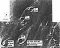
 Streamlined Islands seen by Viking showed that large floods occurred on Mars. Image is located in Lunae Palus quadrangle.
 -
 Tear-drop shaped islands caused by flood waters from Maja Vallis, as seen by Viking Orbiter. Image is located in Oxia Palus quadrangle. The islands are formed in the ejecta of Lod Crater, Bok Crater, and Gold Crater.
 -
 Scour Patterns, located in Lunae Palus quadrangle, were produced by flowing water from Maja Vallis, which lies just to the left of this mosaic. Detail of flow around Dromore Crater is shown on the next image.
 -
 Great amounts of water were required to carry out the erosion shown in this Viking image. Image is located in Lunae Palus quadrangle. The erosion shaped the ejecta around Dromore Crater.
 -
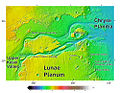
 Waters from Vedra Vallis, Maumee Vallis, and Maja Valles went from Lunae Planum on the left, to Chryse Planitia on the right. Image is located in Lunae Palus quadrangle and was taken by Viking Orbiter.
 -
 Area around Northern Kasei Valles, showing relationships among Kasei Valles, Bahram Vallis, Vedra Vallis, Maumee Vallis, and Maja Valles. Map location is in Lunae Palus quadrangle and includes parts of Lunae Planum and Chryse Planitia.
 -
 The ejecta from Arandas Crater acts like mud. It moves around small craters (indicated by arrows), instead of just falling down on them. Craters like this suggest that large amounts of frozen water were melted when the impact crater was produced. Image is located in Mare Acidalium quadrangle and was taken by Viking Orbiter.
 -
 This view of the flank of Alba Patera shows several chnnels/troughs. Some channels are associated with lava flows; others are probably caused by running water. A large trough or graben turns into a line of collapse pits. Image is located in Arcadia quadrangle and was taken by Viking Orbiter.
 -
 Branched channels in Thaumasia quadrangle, as seen by Viking Orbiter. Networks of channels like this are strong evidence for rain on Mars in the past.
 -
 The branched channels seen by Viking from orbit strongly suggested that it rained on Mars in the past. Image is located in Margaritifer Sinus quadrangle.
 -
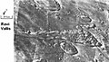 Ravi Vallis, as seen by Viking Orbiter. Ravi Vallis was probably formed when catastrophic floods came out of the ground to the right (chaotic terrain). Image located in Margaritifer Sinus quadrangle.


The high resolution Mars Orbiter Camera on the Mars Global Surveyor has taken pictures which give much more detail about the history of liquid water on the surface of Mars. Despite the many giant flood channels and associated tree-like network of tributaries found on Mars there are no smaller scale structures that would indicate the origin of the flood waters. It has been suggested that weathering processes have denuded these indicating the river valleys are old features. Higher resolution observations from spacecraft like Mars Global Surveyor also revealed at least a few hundred features along crater and canyon walls that appear similar to terrestrial seepage gullies. The gullies tended to be Equator facing and in the highlands of the southern hemisphere, and all poleward of 30° latitude.[35] The researchers found no partially degraded (i.e. weathered) gullies and no superimposed impact craters, indicating that these are very young features.
Another theory about the formation of the ancient river valleys is that rather than floods, they were created by the slow seeping out of groundwater. This observation is supported by the sudden ending of the river networks in theatre shaped heads, rather than tapering ones. Also valleys are often discontinuous, small sections of uneroded land separating the parts of the river.[36]
On the other hand, evidence in favor of heavy or even catastrophic flooding is found in the giant ripples in the Athabasca Vallis [1].
Liquid water

Liquid water cannot exist on the surface of Mars with its present low atmospheric pressure, except at the lowest elevations for short periods.[37][38] Recently, there has been evidence to support the popular belief that liquid water flowed on the surface in the recent past, with the discovery of gully deposits that were not seen ten years ago.[39][40]
Among the findings from the Opportunity rover is the presence of hematite on Mars in the form of small spheres on the Meridiani Planum. The spheres are only a few millimetres in diameter and are believed to have formed as rock deposits under watery conditions billions of years ago. Other minerals have also been found containing forms of sulfur, iron or bromine such as jarosite. This and other evidence led a group of 50 scientists to conclude in the December 9, 2004 edition of the journal Science that "Liquid water was once intermittently present at the Martian surface at Meridiani, and at times it saturated the subsurface. Because liquid water is a key prerequisite for life, we infer conditions at Meridiani may have been habitable for some period of time in Martian history". Later studies suggested that this liquid water was actually acid because of the types of minerals found at the location[41][42]. On the opposite side of the planet the mineral goethite, which (unlike hematite) forms only in the presence of water, along with other evidence of water, has also been found by the Spirit rover in the "Columbia Hills".

On July 31, 2008, NASA announced that the Phoenix lander confirmed the presence of water ice on Mars,[43] as predicted on 2002 by the Mars Odyssey orbiter.
Studies have shown that various salts present in the Martian soil could act as a kind of antifreeze—keeping water liquid way below its normal freezing point.[44][45] Some calculations suggest that tiny amounts of liquid water may be present for short periods of time (hours) in some locations.[46] Some reseachers have calculated that when takiing into consideration insolation and pressure factors that liquid water could exist in some areas for about 10% of the Martian year;[47] others estimate that water could be a liquid for only 2% of the year.[48] Either way, that may be enough liquid water to support some forms of hardy organisms. It may not take much liquid water for life; organisms have been found on Earth living on extremely thin layers of unfrozen water in below-freezing locations.[49] Research described in December 2009, showed that liquid water could form in the daytime inside of snow on Mars. As light heats ice, it may be warming up dust grains located inside. These grains would then store heat and form water by melting some of the ice. The process has been already been observed in Antarctica. Enough water may be produced for physical, chemical, and biological processes.[50][51]
Polar ice caps

Both the northern polar cap (Planum Boreum) and the southern polar cap (Planum Australe) are believed to grow in thickness during the winter and partially sublime during the summer. Data obtained by the Mars Express satellite, made it possible in 2004 to confirm that the southern polar cap has an average of 3 kilometres (1.9 mi) thick slab of CO2 ice[52] with varying contents of frozen water, depending on its latitude; the polar cap is a mixture of 85% CO2 ice and 15% water ice.[53] The second part comprises steep slopes known as 'scarps', made almost entirely of water ice, that fall away from the polar cap to the surrounding plains.[53] The third part encompasses the vast permafrost fields that stretch for tens of kilometres away from the scarps.[53][54] NASA scientists calculate that the volume of water ice in the south polar ice cap, if melted, would be sufficient to cover the entire planetary surface to a depth of 11 metres.[55]
Research, published in January 2010 using HiRISE images, says that understanding the layers is more complicated then was formerly believed. The brightness of the layers does not just depend on the amount of dust. The angle of the sun together with the angle of the spacecraft greatly affect the brightness seen by the camera. This angle depends on factors such as the shape of the trough wall and its orientation. Furthermore, the roughness of the surface can greatly change the albedo (amount of reflected light). In addition, many times what one is seeing is not a real layer, but a fresh covering of frost. All of these factors are influenced by the wind which can erode surfaces. The HiRISE camera did not reveal layers that were thinner than those seen by the Mars Global Surveyor. However, it did see more detail within layers. [56]
Ice patches
On July 28, 2005, the European Space Agency announced the existence of a crater partially filled with frozen water;[57] some then interpreted the discovery as an "ice lake".[58] Images of the crater, taken by the High Resolution Stereo Camera on board the European Space Agency's Mars Express spacecraft, clearly show a broad sheet of ice in the bottom of an unnamed crater located on Vastitas Borealis, a broad plain that covers much of Mars' far northern latitudes, at approximately 70.5° North and 103° East. The crater is 35 km wide and about 2 km deep.
The height difference between the crater floor and the surface of the water ice is about 200 metres. ESA scientists have attributed most of this height difference to sand dunes beneath the water ice, which are partially visible. While scientists do not refer to the patch as a "lake", the water ice patch is remarkable for its size and for being present throughout the year. Deposits of water ice and layers of frost have been found in many different locations on the planet.
Equatorial frozen sea
Surface features consistent with pack ice have been discovered in the southern Elysium Planitia. What appear to be plates of broken ice, ranging in size from 30 m to 30 km, are found in channels leading to a flooded area of approximately the same depth and width as the North Sea. The plates show signs of break up and rotation that clearly distinguish them from lava plates elsewhere on the surface of Mars. The source for the flood is thought to be the nearby geological fault Cerberus Fossae which spewed water as well as lava aged some 2 to 10 million years.[59]
Ancient coastline
A striking feature of the topography of Mars is the flat plains of the northern hemisphere. With the increasing amounts of data returning from the current set of orbiting probes, what seems to be an ancient shoreline several thousands of kilometres long has been discovered. One major problem with the conjectured 2 Ga old shoreline is that it is not flat — i.e. does not follow a line of constant gravitational potential. However a 2007 Nature article points out that this could be due to a change in distribution in Mars' mass, perhaps due to volcanic eruption or meteor impact — the Elysium volcanic province or the massive Utopia basin that is buried beneath the northern plains have been put forward as the most likely causes.[60] The Mars Ocean Hypothesis conjectures that the Vastitas Borealis basin was the site of a primordial ocean of liquid water 3.8 billion years ago.[61]
Geysers on Mars

The seasonal frosting and defrosting of the southern ice cap results in the formation of spider-like radial channels carved between the ground and 1 meter thick ice. Then, sublimed CO2 -and probably water- increase pressure in their interior producing geyser-like eruptions of cold fluids often mixed with dark basaltic sand or mud.[62][63][64][65] This process is rapid, observed happening in the space of a few days, weeks or months, a growth rate rather unusual in geology - especially for Mars.
Glacial phases

A 2008 study provided evidence for multiple glacial phases during Late Amazonian glaciation at the dichotomy boundary on Mars.[66]
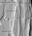
Impact crater morphology

Crater morphology provides information about the physical structure and composition of the surface. Impact craters allow us to look deep below the surface and into Mars geological past. Lobate ejecta blankets (pictured left) and central pit craters are common on Mars but uncommon on the Moon, which may indicate the presence of near-surface volatiles (ice and water) on Mars. Degraded impact structures record variations in volcanic, fluvial, and eolian activity.[67]
The Yuty crater is an example of a Rampart crater so called because of the rampart-like edge of the ejecta. In the Yuty crater the ejecta competely covers an older crater at its side, showing that the ejected material is just a thin layer.[68]
The largest unambiguous impact crater is the Hellas Basin in the southern hemisphere. However, it appears that the Borealis Basin, covering most of the low-lying northern hemisphere, is also an impact crater.[2]
Major Geological Events
On February 19, 2008 an amazing geologic event was captured by the HiRISE camera on the Mars Reconnaissance Orbiter. Images which captured a spectacular avalanche thought to be fine grained ice, dust and large blocks are shown to have fallen from a 2,300-foot (700 m) high cliff. Evidence of the avalanche are shown by the dust clouds rising from the cliff afterwards.[69] Such geological events are theorized to be the cause of geologic patterns known as slope streaks.
Mars Avalanche Photo Gallery
-
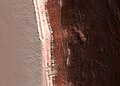 Image of the February 19, 2008 Mars avalanche captured by the Mars Reconnaissance Orbiter.
 -
 Closer shot of the avalanche.
 -
 Dust clouds rise above the 2,300-foot (700 m) deep cliff.
 -
 A photo with scale demonstrates the size of the avalanche.


Slope streaks

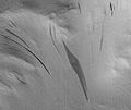
A new phenomenon known as slope streaks has been uncovered by the HiRISE camera on the Mars Reconnaissance Orbiter. These features appear on crater walls and other slopes and are thin but many hundreds of metres long. The streaks have been observed to grow slowly over the course of a year or so, always beginning at a point source. Newly formed streaks are dark in colour but fade as they age until white. The cause is unknown, but theories range from dry dust avalanches (the favoured theory) to brine seepage.[70]
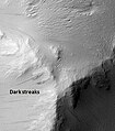
Examples of Dark Slope Streaks from various parts of Mars are shown below. Click on image to get a better view.
-
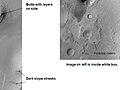 Tikonravev Crater floor in Arabia quadrangle, as seen by Mars Global Surveyor. Click on image to see dark slope streaks and layers.
 -
 Pedestal crater in Amazonis quadrangle with dark streaks, as seen by HiRISE.
 -
 Nicholson crater mound with dark streaks, as seen by HiRISE.
 -
 Tharsis Tholus block in the Tharsis quadrangle, as seen by HiRISE. Block probably tumbled down Tharsis Tholus which is just off to the right.
 -
 Ceraunius Fossae in Tharsis quadrangle, as seen by HiRISE.
 -
 Dark streaks in Diacria quadrangle, as seen by Mars Global Surveyor.


See also
- Dark dune spots
- Elysium Planitia
- Geography of Mars
- Hecates Tholus
- Life on Mars
- Martian dichotomy
- Water on Mars
References
- ^ Yeomans, Donald K. (2006-07-13). "HORIZONS System". NASA JPL. Retrieved 2007-08-08. — At the site, go to the "web interface" then select "Ephemeris Type: ELEMENTS", "Target Body: Mars" and "Center: Sun".
- ^ a b Seidelmann, P. Kenneth (2007). "Report of the IAU/IAGWorking Group on cartographic coordinates and rotational elements: 2006". Celestial Mechanics and Dynamical Astronomy. 90: 155–180. doi:10.1007/s10569-007-9072-y. Retrieved 2007-08-28.
{{cite journal}}: Unknown parameter|coauthors=ignored (|author=suggested) (help) - ^ a b "Mars: Facts & Figures". NASA. Retrieved 2007-03-06.
- ^ a b c David R. Williams (September 1, 2004). "Mars Fact Sheet". National Space Science Data Center. NASA. Retrieved 2006-06-24.
- ^ Clark, B. et al. 1976. Inorganic Analysis of Martian Samples at the Viking Landing Sites. Science: 194. 1283-1288.
- ^ a b ISBN 0-8165-1257-4
- ^ Caplinger, Mike. "Determining the age of surfaces on Mars". Retrieved 2007-03-02.
- ^ Elizabeth R. Fuller, James W. Head III "Amazonis Planitia: The role of geologically recent volcanism and sedimentation in the formation of the smoothest plains on Mars"
- ^ Williams, Chris. "Probe reveals three ages of Mars". Retrieved 2007-03-02.
- ^ Bibring, Jean-Pierre (2006). "Global Mineralogical and Aqueous Mars History Derived from OMEGA/Mars Express Data". Science. 312 (5772): 400–404. doi:10.1126/science.1122659. PMID 16627738.
{{cite journal}}: Cite has empty unknown parameters:|month=and|coauthors=(help) - ^ ISBN 0-8165-1257-4
- ^ Linda M.V. Martel. "Pretty Green Mineral -- Pretty Dry Mars?". psrd.hawaii.edu. Retrieved 2007-02-23.
- ^ Weltz, C. et aL. 2010. Mars Reconnaissance Orbiter observations of light-toned layered deposits and associated fluvial landforms on the plateus adjacent to Valles Marineris. Icarus: 205. 73-102.
- ^ www.sciencedirect.com/science/journal/00191035
- ^ McSween, Jr., H. 1985. SNC Meteorites: Clues to Martian Petrologic Evolution? Reviews of Geophysics: 23. 391-416
- ^ Squyres, S. et al. 2004. In Situ Evidence for an Ancient Aqueous Environment at Meridiani Planum, Mars. Science: 306: 1709-1714.
- ^ Squyres, S. eta al. 2008. Science: 320. 1063-1067
- ^ a b "NASA Mars Page". Volcanology of Mars. Retrieved June 13, 2006.
- ^ a b Peplow, Mark (2004-05-06). "How Mars got its rust". Nature. doi:10.1038/news040503-6. Retrieved 2006-04-18.
{{cite web}}: Cite has empty unknown parameter:|coauthors=(help) - ^ "Mars' soil may be toxic". news.yahoo.com. Retrieved 2008-08-05.
- ^ "NASA Spacecraft Analyzing Martian Soil Data". JPL. Retrieved 2008-08-05.
- ^ "Phoenix Mars Team Opens Window on Scientific Process". 2008-08-05. Retrieved 2008-08-06.
- ^ NASA Mars Global Surveyor
- ^ a b
Arkani-Hamed, Jafar; Boutin, Daniel (July 20-25 2003). "Polar Wander of Mars: Evidence from Magnetic Anomalies" (PDF). Sixth International Conference on Mars. Pasadena, California: Dordrecht, D. Reidel Publishing Co. Retrieved 2007-03-02.
{{cite conference}}: Check date values in:|date=(help); Unknown parameter|booktitle=ignored (|book-title=suggested) (help)CS1 maint: multiple names: authors list (link) - ^ "New Map Provides More Evidence Mars Once Like Earth" - Oct. 12, 2005 Goddard Space Flight Center Press release. URL accessed March 17, 2006.
- ^
Arkani-Hamed, Jafar; Boutin, Daniel (March 2004), [doi:10.1029/2003JE002229 Paleomagnetic poles of Mars: Revisited], Pasadena, California
{{citation}}: Check|url=value (help); Unknown parameter|booktitle=ignored (help)CS1 maint: location missing publisher (link) CS1 maint: multiple names: authors list (link) - ^ "The Solar Wind at Mars". NASA. 2001-01-13. Retrieved 2007-03-16.
- ^ David Shiga "Almighty smash left record crater on Mars" New Scientist 25 June 2008
- ^ Michael Brooks "Giant impact explains Mars's wonky magnetic field" New Scientist 26 September 2008
- ^ Dave Jacqué (2003-09-26). "APS X-rays reveal secrets of Mars' core". Argonne National Laboratory. Retrieved 2006-07-01.
- ^ Dunham, Will (2007-03-15). "Immense ice deposits found at south pole of Mars". Yahoo! News. Yahoo!, Inc. Retrieved 2007-03-16.
- ^ "Tectonic signatures at Aeolis Mensae". ESA News. European Space Agency. 2007-06-28. Retrieved 2007-06-28.
- ^ Raeburn, P. 1998. Uncovering the Secrets of the Red Planet Mars. National Geographic Society. Washington D.C.
- ^ Moore, P. et al. 1990. The Atlas of the Solar System. Mitchell Beazley Publishers NY, NY.
- ^ Malin, Michael C. (2000). "Evidence for Recent Groundwater Seepage and Surface Runoff on Mars". Science. 288 (5475): 2330–2335. doi:10.1126/science.288.5475.2330. PMID 10875910.
{{cite journal}}: Cite has empty unknown parameter:|month=(help); Unknown parameter|coauthors=ignored (|author=suggested) (help) - ^ Jakosky, Bruce M. (1999). "Water, Climate, and Life". Science. 283 (5402): 648–649. doi:10.1126/science.283.5402.648. PMID 9988657.
{{cite journal}}: Cite has empty unknown parameters:|month=and|coauthors=(help) - ^ Heldmann, Jennifer L.; et al. (2005-05-07), "Formation of Martian gullies by the action of liquid water flowing under current Martian environmental conditions" ([dead link] – Scholar search), Journal of Geophysical Research, 110: Eo5004, doi:10.1029/2004JE002261, retrieved 2007-08-12
{{citation}}: Explicit use of et al. in:|last=(help); External link in|format= - ^ Kostama, V.-P.; Kreslavsky, M. A.; Head, J. W. (June 3, 2006), "Recent high-latitude icy mantle in the northern plains of Mars: Characteristics and ages of emplacement", Geophysical Research Letters, 33: L11201, doi:10.1029/2006GL025946, retrieved 2007-08-12 'Martian high-latitude zones are covered with a smooth, layered ice-rich mantle'
- ^ JPL news release 2006-145
- ^ Malin, Michael C. (8 December 2006). "Present-Day Impact Cratering Rate and Contemporary Gully Activity on Mars". Science. 314 (5805): 1573–1577. doi:10.1126/science.1135156. Retrieved 2009-09-03.
{{cite journal}}: Unknown parameter|coauthors=ignored (|author=suggested) (help) - ^ Benison, Kathleen C. and LaClair, Deidre, 2003, Astrobiology, v. 3, p. 609-618.
- ^ Benison, Kathleen C. and Bowen, Brenda B., 2006, Icarus, v. 183, p. 225-229.
- ^ Johnson, John (2008-08-01). "There's water on Mars, NASA confirms". Los Angeles Times. Retrieved 2008-08-01.
- ^ http://www.spaceref.com/news/viewpr.html?pid=28377
- ^ Fairen, A. et al. 2009. Stability against freezing of aqueous solutions on early Mars. Nature: 459. 401-404.
- ^ Kreslavsky, M. et al. 2006. Periods of Active Permafrost Layer Formation During the Geological History of Mars: Implication for Circum-Polar and Mid-Latitude surface Processes. Planetary and space Science Special Issue on Polar Processes: 56. 266-288.
- ^ Lobitz, B. et al. 2001. Special feature: Use of spacecraft data to derive regions on Mars where liquid water would be stable. Proc. natl. Acad. Sci. 98. 2132-2137
- ^ Haberie, et al. 2001. On the possibility of liquid water on present-day Mars. J. Geophysical Research: 106. 23317-23326.
- ^ http://www.universetoday.com/2008/09/04/phoenix-probe-says-both-yes-and-no-to-water-on-mars/
- ^ http://www.newscientist.com/article/mg20427373.700
- ^ news.softpedia.com/news/Greenhouse-Effect-on Mars-May-Be-Allowing-for-Life-129065.shtml
- ^ "Mars' South Pole Ice Deep and Wide". Jet Propulsion Laboratory. NASA. March 15, 2007. Retrieved 2009-09-11.
{{cite news}}: Cite has empty unknown parameter:|coauthors=(help) - ^ a b c "Water at Martian south pole". European Space Agency (ESA). 17 March 2004. Retrieved 2009-09-11.
{{cite news}}: Cite has empty unknown parameter:|coauthors=(help) - ^ Kostama, V.-P.; Kreslavsky, M. A.; Head, J. W. (June 3, 2006), "Recent high-latitude icy mantle in the northern plains of Mars: Characteristics and ages of emplacement", Geophysical Research Letters, 33: L11201, doi:10.1029/2006GL025946, retrieved 2008-08-01
- ^ "Mars' South Pole Ice Deep and Wide". NASA. March 15, 2007. Retrieved 2009-09-13.
- ^ Fishbaugh, K. et al. 2010. Evaluating the meaning of "layer" in the martian north polar layered depsoits and the impact on the climate connection. Icarus: 205. 269-282.
- ^ "Water ice in crater at Martian north pole" - July 27, 2005 ESA Press release. URL accessed March 17, 2006.
- ^ "Ice lake found on the Red Planet" - July 29, 2005 BBC story. URL accessed March 17, 2006.
- ^ Murray, John B. (2005). "Evidence from the Mars Express High Resolution Stereo Camera for a frozen sea close to Mars' equator". Nature. 434: 352–356. doi:10.1038/nature03379.
{{cite journal}}: Cite has empty unknown parameter:|month=(help); Unknown parameter|coauthors=ignored (|author=suggested) (help) - ^ Zuber, Maria T. (2007). "Mars at the tipping point". Nature. 447 (7146): 785–786. doi:10.1038/447785a.
{{cite journal}}: Cite has empty unknown parameters:|month=and|coauthors=(help) - ^ Baker, V. R., R. G. Strom, V. C. Gulick, J. S. Kargel, G. Komatsu and V. S. Kale, 1991: Ancient oceans, ice sheets and the hydrological cycle on Mars, Nature, 352, 589-594.
- ^ "NASA Findings Suggest Jets Bursting From Martian Ice Cap". Jet Propulsion Laboratory. NASA. August 16, 2006. Retrieved 2009-08-11.
{{cite news}}: Cite has empty unknown parameter:|coauthors=(help) - ^ Kieffer, H. H. (2000), "ANNUAL PUNCTUATED CO2 SLAB-ICE AND JETS ON MARS." (PDF), Mars Polar Science 2000, retrieved 2009-09-06
{{citation}}:|format=requires|url=(help); Cite has empty unknown parameters:|coeditors=and|coauthors=(help) - ^ "SIMULATIONS OF GEYSER-TYPE ERUPTIONS IN CRYPTIC REGION OF MARTIAN SOUTH" (PDF), Fourth Mars Polar Science Conference, 2006, retrieved 2009-08-11
{{citation}}:|editor-first=missing|editor-last=(help);|format=requires|url=(help); Cite has empty unknown parameters:|coeditors=and|coauthors=(help) - ^ Kieffer, Hugh H. (30 May 2006). "CO2 jets formed by sublimation beneath translucent slab ice in Mars' seasonal south polar ice cap". Nature. 442: 793–796. Error: Bad DOI specified!. Retrieved 2009-09-02.
{{cite journal}}: Unknown parameter|coauthors=ignored (|author=suggested) (help) - ^ Dickson, James L. (2008). "Late Amazonian glaciation at the dichotomy boundary on Mars: Evidence for glacial thickness maxima and multiple glacial phases". Geology. 36 (5): 411–414. doi:10.1130/G24382A.1.
{{cite journal}}: Cite has empty unknown parameter:|month=(help); Unknown parameter|coauthors=ignored (|author=suggested) (help) - ^ Nadine Barlow. "Stones, Wind and Ice". Lunar and Planetary Institute. Retrieved 2007-03-15.
- ^ "Viking Orbiter Views Of Mars". NASA. Retrieved 2007-03-16.
- ^ DiscoveryChannel.ca - Mars avalanche caught on camera
- ^ "Newly-Formed Slope Streaks". NASA. Retrieved 2007-03-16.