Arica
Arica | |
|---|---|
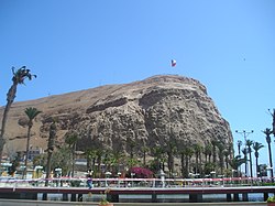
 Plaza de Colón: Columbus Square | |
| Country | |
| Admin. division | Arica and Parinacota Region |
| Population (2005) | |
| • Total | 192,300 |
| Website | http://www.municipalidaddearica.cl/ |
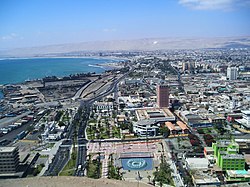
Arica is a commune and a port city with a population of 192,300 in the Arica and Parinacota Region in northern Chile, located only 18 km (11 miles) south of the border with Peru.
History
Archaeological research has indicated the site of Arica was inhabited by different native groups for at least ten thousand years. The city was founded by Spanish captain Lucas Martinez de Begazo in 1541, and in 1570 was entitled as "La Muy Ilustre y Real Ciudad San Marcos de Arica" (the very illustrious and royal city of San Marcos of Arica). This city was since 1545 the port for exporting the silver of Potosí.
The Potosi silver mine was the largest such mine in world history. Because of it, Arica became a crucial port for the Spanish Empire. This port was looted by such famous pirates, buccaneers, and privateers as Francis Drake, Thomas Cavendish, Richard Hawkins, Joris van Spilbergen, John Watling, Simon de Cordes, Leandro de Valencia, Bartholomew Sharp, William Dampier, and John Clipperton.
Arica was occupied by Bolivia once between 1836-1839 and again between 1841-1842 after the Battle of Ingavi.
In 1855 the Peruvian government inaugurated the Arica-Tacna railroad (53 km long), one of the first in Latin America. The rail line still functions.
In 1958, the Chilean Government established the "Junta de Adelanto de Arica" (Board of Development for Arica), which promulgated many tax incentives for the establishment of industries, such as vehicles assembly plants, a tax-free zone, a casino, among others.[1] Many car manufacturers opened plants in Arica, such as Citroen, Peugeot, Volvo, Ford and General Motors, which produced the Chevrolet LUV pick-up until 2008.
In 1975, together with Chile's new open Economy policies, the "Junta de Adelanto de Arica" was derogated.
Features


The city is the capital of the recently created Arica and Parinacota Region (October 2007). It has a population of approximately 200,000 and is known as the "city of the eternal spring".
The Morro de Arica is a steep and tall hill located in the city. Its height is 139 meters above sea level. It was the last bulwark of defence for the Peruvian troops who garrisoned the city. It was assaulted and captured on June 7, 1880 by Chilean troops in the last part of their Campaña del Desierto (Desert Campaign) during the War of the Pacific.
Near the city is the Azapa Valley, an oasis where vegetables and Azapa olives are grown. Economically, it is an important port for Chilean ore, and its tropical latitude, dry climate, and the city's beach, have made Arica a popular tourist destination. It is also a center of rail communication with Bolivia and has its own international airport. Arica has strong ties with the city of Tacna, Peru; many people cross the border daily to travel between the cities, partly because many services (for example, dentists) are cheaper on the Peruvian side. Arica is connected to Tacna and to La Paz, Bolivia by separate railroad lines.
Climate
Arica is also known as one of the driest inhabited places on Earth, at least as measured by rainfall: average annual precipitation is 0.76 mm (0.03 inches), as measured at the airport meteorological station.[2]. Despite its lack of rainfall, humidity and cloud cover are high. With humidity levels similar those of Equatorial climates. Sunshine levels are very low for a desert climate and the latitude, comparable to those of London or Moscow. Oxford geographer Nick Middleton's book on people who live in extreme climates, Going to Extremes (ISBN 0-330-49384-1), discusses his visit to this city.
| Climate data for Arica | |||||||||||||
|---|---|---|---|---|---|---|---|---|---|---|---|---|---|
| Month | Jan | Feb | Mar | Apr | May | Jun | Jul | Aug | Sep | Oct | Nov | Dec | Year |
| Source: Washington Post[3] | |||||||||||||
Important events
- On August 16, 1868, the Peruvian port of Arica was devastated by a tsunami which followed a magnitude 8.5 earthquake in what is now called Peru-Chile Trench off the coast. Some historians claim that the earthquake and tsunami killed an estimated 25,000 people in Arica and perhaps 70,000 people in all.[4] Others estimate that the population of Arica was less than 3000 people and the death toll was around 300.
- Arica was one of the four host cities of the 1962 football (soccer) World Cup.
- Arica was the venue for a Rip Curl Pro Search surfing event that took place from June 20 to July 1, 2007.
- Arica Harbor is the name of a map in the first-person shooter video-game Battlefield: Bad Company 2, the map being based on the city's harbor area.
Tourist attractions
Morro de Arica. Catedral de San Marcos de Arica. Plaza Colón in downtown Arica.
Among the attractions are the Arica Morro de Arica, the "founding square" (for the civic center of town), the Cathedral of San Marcos de Arica, the former house of the Governor, the House of Culture, railway station Arica-La Paz, the Archaeological and Anthropological Museum of San Miguel de Azapa, Sea and Historical Arms and Arica. For evening entertainment there is the "Casino de Arica".
Beaches
More than 20 km of beaches, and across the Coastal Range in the northern sector, which makes particular and different to other cities in Chile in terms of topography.
From north to south the beaches are located Las Machas, Chinchorro, del Alacrán, El Laucho, La Lisera, Brava, Arenillas Negras, La Capilla, Corazones and La Liserilla.
Other tourist sites
- Chungará Lake: Arica is the main access road to the lake, the 29th highest in the world (and the 10th highest in South America)[1], with an approximate height of 4517 meters. It is located within the Lauca National Park.
- Pucará de Copaquilla: about 3000 meters above sea level, dates from the twelfth century, declared National Monument, located on a promontory that serves as the defense has a double stone wall, which protects a series of internal spaces. From this point it is possible to observe the pre-and streams.
- Termas de Jurasi a few miles southeast of Putre, by Ruta 11-CH, turning off a dirt road. Underground waters are home to temperatures above 40 °C which are reputed to have medicinal properties.
- Surf Arica is a world-famous spot for surfing. The wave known as "El Gringo" hosts surfing and bodyboarding world championships every year. In 2007, Arica was the site for an ASP world tour contest. Others stops on this tour include Hawaii, Tahiti, Fiji and South Africa.
Notable residents
- Dante Poli - Former football player
- Hipólito Unanue - Physician, and briefly president of Peru
- Américo - Chilean singer
References
- ^ http://www.leychile.cl/Navegar?idNorma=27344
- ^ "Weather recorders". Met Office. Retrieved 2007-08-24.
- ^ [http://www.washingtonpost.com/wp-srv/weather/longterm/historical/data/arica_chile.htm?
- ^ The 1868 Arica Tsunami

