
Scarborough Shoal
 | |
| Other names | Scarborough Reef Huangyan Island Minzhu Jiao Panatag Shoal Bajo de Masinloc |
|---|---|
| Geography | |
| Location | South China Sea |
| Coordinates | 15°11′N 117°46′E / 15.183°N 117.767°E |
| Archipelago | 150 square kilometres (58 sq mi) |
| Demographics | |
| Population | none |
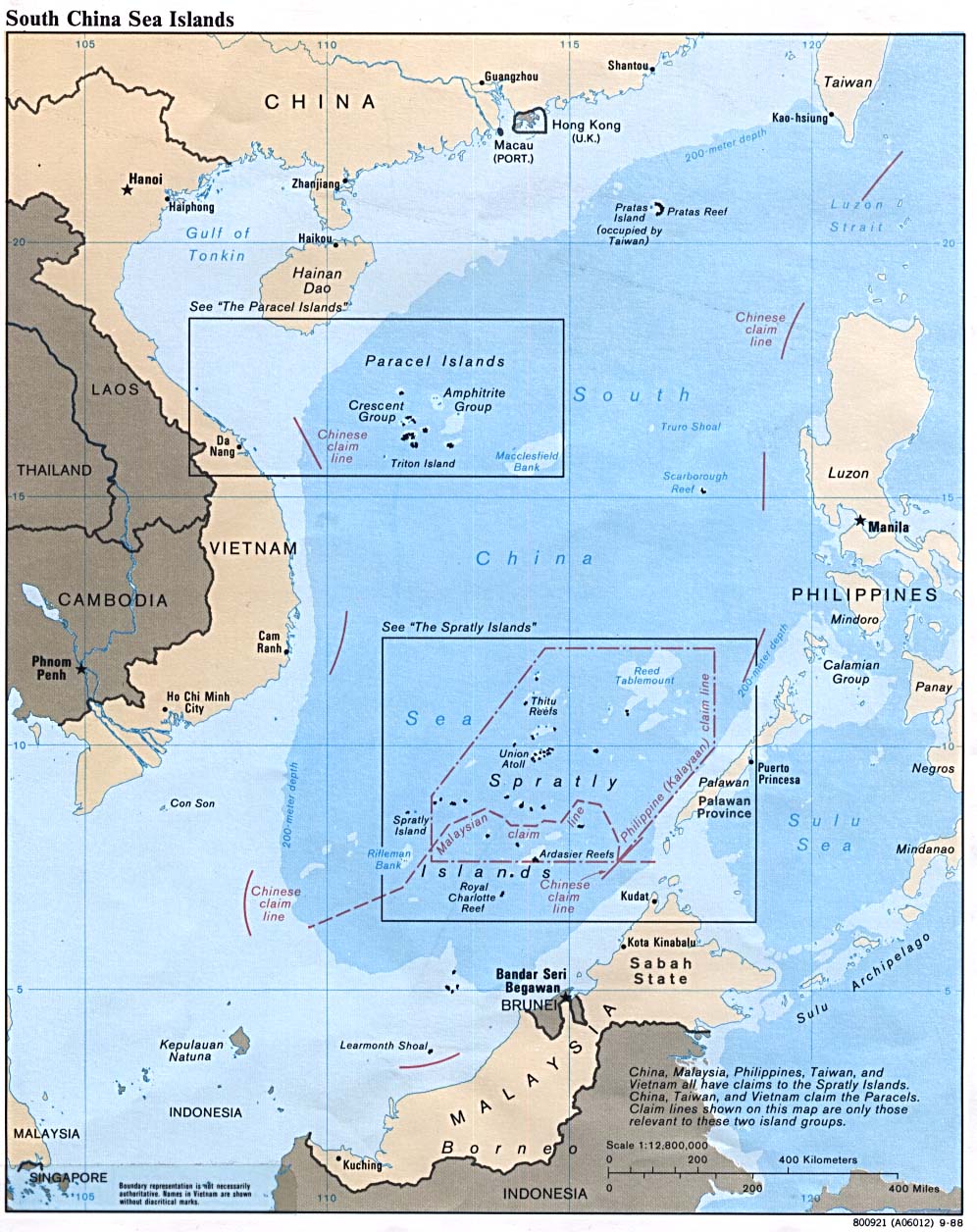
Scarborough Shoal or Scarborough Reef[1] ( Chinese name: Huangyan Island; simplified Chinese: 黄岩岛; traditional Chinese: 黃岩島; pinyin: Huángyán Dǎo; Philippine name: Panatag Shoal, Bajo de Masinloc), more correctly described as a group of islands and reefs in an atoll shape than a shoal, is located between the Macclesfield Bank(Zhongsha Islands) and Luzon Island of Philippines in the South China Sea. To the east, the 5,000 - 6,000 meter deep Manila Trench separates the shoal from Philippine Archipelago. As with most of the landforms in this sea, the sovereignty of the area is disputed. After the Chinese Civil War, the People's Republic of China and the Republic of China (Taiwan) both lay claim to the shoal. Starting in 1997, Philippines[2] joined in this dispute, making its claim to the shoal.
The shoal was named after a tea-trade ship Scarborough which was wrecked on the rock with everyone perishing on board in the late 18th century.[3]
Geography

The shoal forms a triangle-shaped chain of reefs and islands (but mostly rocks) 55 kilometres (34 mi) around with an of area 150 square kilometers. It has a lagoon with area of 130 km² and depth of about 15 metres (49 ft). The shoal is a protrusion from a 3,500 m deep abyssal plain. Several of the islands including "South Rock" are 1/2 m to 3 m high and many of the reefs are just below water at high tide. Near the mouth of the lagoon are the ruins of an iron tower, 8.3 m high. It is about 123 miles (198 km) west of Subic Bay. The nearest landmass is Palauig, Zambales, on Luzon Island in the Philippines, 137 miles (220 km) away.
Activities in the surrounding area
The shoal and its surrounding area are rich fishing grounds. A significant number of Chinese fishermen have been arrested by Philippine officials in this area, particularly during 1998-2001. Most arrests were for alleged using illegal methods of fishing and catching endangered and protected species. [citation needed]
There are thick layers of guano lying on the rocks in the area. Several Filipino-sponsored and Chinese-sponsored diving excursions and amateur ham radio operations, DXpeditions (1994, 1995, 1997 and 2007), have been carried out in the area. [citation needed]
Sovereignty dispute
The People's Republic of China and Republic of China (Taiwan)

The People's Republic of China and the Republic of China (Taiwan) claim that the shoal was first discovered and drawn in a map in the Yuan Dynasty as early as 1279 and was historically used by Chinese fishermen. In 1279, Guo Shoujing, a Chinese astronomer, performed surveying of the South China Sea, and the surveying point was reported to be the Scarborough Shoal. In 1935, China regarded the shoal as part of the Zhongsha Islands.[4] In 1947, the shoal was given the name Minzhu Jiao. In 1983, it was renamed Huangyan Island with Minzhu Jiao reserved as a second name. [5] In 1956, China protested Philippine remarks that South China Sea islands in close proximity to Philippine territory should belong to the Philippines. China's Declaration on the territorial Sea, promulgated in 1958, says in part,
The breadth of the Territorial Sea of the People's Republic of China shall be twelve nautical miles. This applies to all territories of the People's Republic of China, including the Chinese mainland and its coastal islands, as well as Taiwan and its surrounding islands, the Penghu Islands, the Dongsha Islands, the Xisha Islands, the Zhongsha Islands [italics added], the Nansha Islands and all other islands belonging to China which are separated from the mainland and its coastal islands by the high seas.[6]
China reaffirmed its claim of sovereignty over the Zhongsha Islands in its 1992 Law on the territorial Sea and the Contiguous Zone. China claims all the islands, reefs, and shoals within a U-shaped line in the South China Sea drawn in 1947 as its territory. Scarborough shoal lies within this area.[6]
China further asserted its claim shortly after the departure of the US Navy force from Subic, Zambales, Philippines. In the late 1970s, many scientific expedition activities organized by State Bureau of Surveying, National Earthquake Bureau and National Bureau of Oceanography were held in the shoal and around this area. In 1980, a stone marker reading "South China Sea Scientific Expedition" was installed on the South Rock, but was removed by Philippines in 1997.
The Philippine government has proposed taking the Panatag issue to the International Tribunal on the Law of the Sea, but the Chinese government has rejected this, insisting on bilateral discussions.[7]
The Philippines

The Philippines claims that as early as the Spanish colonization of the Philippines, Filipino fishermen were already using the area as a traditional fishing ground and shelter during bad weather.[8] In 1957, The Philippine government conducted an oceanographic survey of the area and together with the US Navy force based in then U.S. Naval Base Subic Bay in Zambales, used the area as an impact range for defense purposes. An 8.3 meter high flag pole flying a Philippine flag was raised in 1965. A small lighthouse was also built and operated the same year.[9] In 1992, the Philippine Navy rehabilitated the lighthouse and reported it to the International Maritime Organization for publication in the List of Lights. As of 2009, the military-maintained lighthouse is non-operational.[10]
Several Official Philippines maps published by Spain and United States in 18th and 20th century show Scarborough Shoal as Philippine territory. The 18th-century map "Carta hydrographica y chorographica de las Islas Filipinas" (1734) shows the Scarborough Shoal then was named as Panacot Shoal. The map also shows the shape of the shoal as consistent with the current maps available as today. During the 1900s Mapa General. Islas Filipinas, Observatorio de Manila and US Coast and Geodetic Survey Map includes the Scarborough Shoal named as "Baju De Masinloc".[11] In 1792, another map drawn by the Malaspina expedition and published in 1808 in Madrid, Spain also showed Bajo de Masinloc as part of Philippine territory. The map showed the route of the Malaspina expedition to and around the shoal. It was reproduced in the Atlas of the 1939 Philippine Census, which was published in Manila a year later and predates the controversial 1947 Chinese South China Sea Claim Map that shows no chinese name on it .[12] Another topographic map drawn in 1820 shows the shoal, named there as "Bajo Scarburo", as a constituent part of Sambalez (Zambales province).[13]
The Scarborough Shoal is not included within the territorial lines defined in the Treaty of Paris (1898)[14] between the United States, Treaty of Washington (1900) between Spain and the United States,[15] Convention Between the United States and Great Britain (1930),[16] Constitution of the Philippines (1935), or Republic Act No. 3046 "Act to Define the Baselines of the Territorial Sea of the Philippines"(1961),[17].The Philippine Department of Foreign Affairs asserts that the basis of Philippine sovereignty and jurisdiction over the rock features of Bajo de Masinloc is not premised on the cession by Spain of the Philippine archipelago to the United States under the Treaty of Paris, and argues that the matter that the rock features of Bajo de Masinloc are not included or within the limits of the Treaty of Paris as alleged by China is therefore immaterial and of no consequence.[18]
The Philippines bases its claim on its proximity and the principle of terra nullius, which holds that it was previously unclaimed by a sovereign state, which is also applied by the Philippines in its claims to the Spratly Islands. By virtue of the Presidential Decree No. 1599 issued by President Ferdinand Marcos on June 1978, the Philippines claims an Exclusive Economic Zone (EEZ) up to 200 nautical miles (370 km) from the baselines from which their territorial sea is measured.[19] In 2009, President Gloria Macapagal-Arroyo enacted the Philippine Baselines Law of 2009 (RA 9522). The new law classifies the Spratly Islands and the Scarborough Shoal as a regime of islands under the Republic of the Philippines.[20]
The Department of Foreign Affairs bases the Philippine claim on Scarborough Shoal citing the Island of Palmas Case, where the sovereignty of the island was adjudged in favor of the Netherlands because of effective jurisdiction and control, despite the historic claim of Spain. The Philippines has exercised effective jurisdiction and effective occupation of the shoal since its independence. It also explains that the Exclusive Economic Zone claim on the waters around Scarborough is different from the sovereignty exercised by the Philippines in the shoal. [18]
References
- ^ "The 'Spratly deal': facts & figures". The Philippine Star. March 10, 2008. Retrieved 2008-08-06. [dead link]
- ^ "SCARBOROUGH REEF: A NEW FLASHPOINT IN SINO-PHILIPPINE RELATIONS?" (PDF). IBRU Boundary and Security Bulletin Summer 1999. 1999.
- ^ Richard Bayly (Colonel.) (1896). Diary of Colonel Bayly, 12th Regiment, 1796-1830. Naval & Military Press. p. 108.
- ^ Zou 2005, p. 63.
- ^ Zou 2005, p. 62.
- ^ a b Zou 2005, p. 64.
- ^ "China deploys gunboat". Philippine Daily Inquirer. April 20, 2012.
- ^ Zou 2005, pp. 64–65.
- ^ What’s become of the MMDA?[dead link], Philippine Star, 2 April 2008
- ^ COAST GUARD DISTRICT NATIONAL CAPITAL REGION - CENTRAL LUZON LIGHTSTATIONS (archived from the original on 2010-01-16)
- ^ In a Troubled Sea: Reed Bank, Kalayaan, Lumbay, Galit, and Panacot - Yahoo! News Philippines
- ^ ‘Panatag Shoal ours since 1734’ | Top Stories
- ^ "Scarborough belongs to PH, old maps show". Philippine Daily Inquirer. April 23, 2012.
- ^ "Treaty of Peace Between the United States and Spain; December 10, 1898". Avalon Project.
- ^ "TREATY BETWEEN SPAIN AND THE UNITED STATE FOR CESSION OF OUTLYING ISLANDS OF THE PHILIPPINES" (PDF). University of the Philippines. November 7, 1900.
- ^ United States. Dept. of State; Charles Irving Bevans (1968). Treaties and other international agreements of the United States of America, 1776-1949. Dept. of State; for sale by the Supt. of Docs., U.S. Govt. Print. Off. pp. 473–476.
- ^ "REPUBLIC ACT NO. 3046 (as amended by RA 5446) AN ACT DEFINE THE BASELINES OF THE TERRITORIAL SEA OF THE PHILIPPINES". Chan Robles Law library. June 17, 1961.
- ^ a b Philippine Position on Bajo de Masinloc and the Waters Within its Vicinity
- ^ "PRESIDENTIAL DECREE No. 1599 ESTABLISHING AN EXCLUSIVE ECONOMIC ZONE AND FOR OTHER PURPOSES". Chan Robles Law Library. June 11, 1978.
- ^ Philippine Baselines Law of 2009 (March 11, 2009), GMA News.
- Zou, Keyuan (2005). Law of the Sea in East Asia: Issues And Prospects. RoutledgeCurzon. ISBN 978-0-415-35074-7.
{{cite book}}: Invalid|ref=harv(help)
External links
- VirtualInformationCenter - includes many more references[dead link]
- Map of the South China Sea showing Scarborough Shoal
- Google Map showing relative position of Scarborough Shoal with Philippines and China
- Scarborough Shoal, a new Sino-Philippine conflict
- Chinese marker in Panatag Shoal (archived from the original on 2011-05-19)
- Stone marker "South China Sea Scientific Expedition" by State Bureau of Surveying, National Earthquake Bureau and National Bureau of Oceanography of China
- Pictures show disputes between China and Philippines
| |||||||||
| |||||||||