Mirpur District
Mirpur
ضلع میر پور | |
|---|---|
 | |
| Coordinates: 33°08′57″N 73°45′12″E / 33.1491°N 73.7534°E | |
| Country | Pakistan |
| Established | 1947 |
| Headquarters | Mirpur |
| Area | |
| • Total | 1,010 km2 (390 sq mi) |
| Population (2017) | |
| • Total | 456,200 |
| • Density | 452/km2 (1,170/sq mi) |
| Time zone | UTC+5 (PST) |
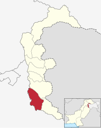
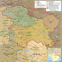
Mirpur district (ضلع میر پور) is a district in Mirpur Division of Azad Kashmir,[1] a region administered by Pakistan as a self-governing jurisdiction, and constituting the western portion of the larger Kashmir region which has been the subject of a dispute between India and Pakistan since 1947, and between India and China from somewhat later.[2] The district is named after the main city, Mirpur. The district of Mirpur has a population of 456,200[3] and covers an area of 1,010 km2 (390 sq mi). The district is mainly mountainous with some plains. Its hot, dry climate and other geographical conditions closely resemble those of Jhelum and Gujrat, the adjoining districts of Punjab.
History

During the British colonial times, Mirpur was one of the five districts of the Jammu province in the princely state of Jammu and Kashmir.[4][5] According to the 1941 census, the it had a population of 386,655, roughly 80% of whom were Muslim and 16% were Hindu.[6] It consisted of three tehsils: Kotli, Mirpur and Bhimber.[7] Kotli and Bhimber have since been made into separate districts. The three districts constitute the present day Mirpur Division in the Pakistan-administered Kashmir. Small portions of the erstwhile Mirpur district are also included in the Rajouri district in the Indian-administered Kashmir.
The original Mirpur district, along with the districts of Poonch and Rajouri, had close geographic, ethnic and cultural connections with West Punjab, more so than with the Jammu city and the rest of the Jammu province. Due to these reasons, scholar Christopher Snedden states that the people of Mirpur had a strong desire to join Pakistan during the Partition of India.[8]
Language and ethnicity
There is considerable ambiguity surrounding the name of the local language:[9] its speakers call it variously Pahari, Mirpur Pahari, Mirpuri and Pothwari,[10] while some label it as Punjabi.[11] Sociolinguists have regarded it as one of the three major dialects of the Pahari-Pothwari language complex,[12] which is intermediate between Lahnda and Punjabi.[13] Mirpur Pahari is mutually intelligible with the other two major dialects – Pothwari of the Potohar Plateau in Punjab and the Pahari spoken to the north in Azad Kashmir and around Murree – and shares with them between 77 and 84% of its basic vocabulary,[14] although the difference with the northernmost varieties (in Muzaffarabad) is sufficient to impede understanding.[15] Mirpuri speakers have a strong sense of Kashmiri identity that takes precedence over linguistic identification with closely related groups outside of Azad Kashmir.[16]
Another language spoken here is Gujari. The local dialect is closely related to the Gujari varieties spoken in the rest of Azad Kashmir and in Hazara.[17] Other languages spoken include Urdu and English.
The vast majority of the district's population belong to the Jatt ethnic group followed by Rajputs and Gujjars.[citation needed] The rest were lower caste people known as massalis up to the 1950s.[18] They included artisans like nais, chamars, mochis, telis and others. These groups eventually left their massalin Mirpuri Potohari; the Majh and Gojri dialects of Punjabi Language are now the predominant languages of the district.[citation needed]
Government

The district is administratively subdivided into 3 Tehsils:
Villages
- Mirpur tehsil
Afzalpur, Abdulahpur, Andrah Kalan, Arah Jagir, Ballah, Pakhral, Bajjar, Banni, Bongdawara, Burjan, Chabrian Dattan, Chak Haryam, Chakswari, Chandral, Chak Sagar, Chatan, Chechian, Chitterpari, Dalyala, Dheri Thothal, Rathoa, Ghaseetpur Awan, Ghaseetpur Sohalian, Islamgarh, Mora Rakhyal, Mora Loharan, Mora Rathyan, Mankarah, New City, Tariq Abad, Jatlan, Jangian Kotla, Kakra, Kalyal Bhainsi, Kas Kalyal, Khari Sharif, Khokhar, Mehmunpur, Mori, Nagial, Pindi Subherwal, Potha Bainsi, Sahang, Saleemabad, SukhChainPur, Nawan Garan, Gorsian, Chak Ghayan, Raipur, and Palyala.
- Dadyal tehsil
Amb, Chattroh, Haveli Baghal, Kathar Dilawar, Mandi, Mohra Malkan, Mohra Sher Shah, Rajoa, Ratta, Sahalia, Siakh Pahaith, Thalarajwali Khan, Thub Jagir, and Ankar Raajgan.
References
- ^ - Government Website
- ^ The application of the term "administered" to the various regions of Kashmir and a mention of the Kashmir dispute is supported by the tertiary sources (a) through (d), reflecting due weight in the coverage. Although "controlled" and "held" are also applied neutrally to the names of the disputants or to the regions administered by them, as evidenced in sources (e) through (g) below, "held" is also considered politicized usage, as is the term "occupied," (see (h) below):
(a) Editors of Encyclopaedia Britannia, Kashmir, region Indian subcontinent, Encyclopaedia Britannica, retrieved 15 August 2019{{citation}}:|last1=has generic name (help) (subscription required) Quote: "Kashmir, region of the northwestern Indian subcontinent ... has been the subject of dispute between India and Pakistan since the partition of the Indian subcontinent in 1947. The northern and western portions are administered by Pakistan and comprise three areas: Azad Kashmir, Gilgit, and Baltistan, the last two being part of a territory called the Northern Areas. Administered by India are the southern and southeastern portions, which constitute the state of Jammu and Kashmir but are slated to be split into two union territories.";
(b) Pletcher, Kenneth, Aksai Chin, Plateau Region, Asia, Encyclopaedia Britannica, retrieved 16 August 2019 (subscription required) Quote: "Aksai Chin, Chinese (Pinyin) Aksayqin, portion of the Kashmir region, at the northernmost extent of the Indian subcontinent in south-central Asia. It constitutes nearly all the territory of the Chinese-administered sector of Kashmir that is claimed by India to be part of the Ladakh area of Jammu and Kashmir state.";
(c) "Kashmir", Encyclopedia Americana, Scholastic Library Publishing, 2006, p. 328, ISBN 978-0-7172-0139-6 C. E Bosworth, University of Manchester Quote: "KASHMIR, kash'mer, the northernmost region of the Indian subcontinent, administered partlv by India, partly by Pakistan, and partly by China. The region has been the subject of a bitter dispute between India and Pakistan since they became independent in 1947";
(d) Talbot, Ian (2016), A History of Modern South Asia: Politics, States, Diasporas, Yale University Press, pp. 28–29, ISBN 978-0-300-19694-8 Quote: "We move from a disputed international border to a dotted line on the map that represents a military border not recognized in international law. The line of control separates the Indian and Pakistani administered areas of the former Princely State of Jammu and Kashmir.";
(e) Editors of Encyclopaedia Britannia, Kashmir, region Indian subcontinent, Encyclopaedia Britannica, retrieved 15 August 2019{{citation}}:|last1=has generic name (help) (subscription required) Quote: "... China became active in the eastern area of Kashmir in the 1950s and has controlled the northeastern part of Ladakh (the easternmost portion of the region) since 1962.";
(f) Bose, Sumantra (2009), Kashmir: Roots of Conflict, Paths to Peace, Harvard University Press, pp. 294, 291, 293, ISBN 978-0-674-02855-5 Quote: "J&K: Jammu and Kashmir. The former princely state that is the subject of the Kashmir dispute. Besides IJK (Indian-controlled Jammu and Kashmir. The larger and more populous part of the former princely state. It has a population of slightly over 10 million, and comprises three regions: Kashmir Valley, Jammu, and Ladakh.) and AJK ('Azad" (Free) Jammu and Kashmir. The more populous part of Pakistani-controlled J&K, with a population of approximately 2.5 million. AJK has six districts: Muzaffarabad, Mirpur, Bagh, Kodi, Rawalakot, and Poonch. Its capital is the town of Muzaffarabad. AJK has its own institutions, but its political life is heavily controlled by Pakistani authorities, especially the military), it includes the sparsely populated "Northern Areas" of Gilgit and Baltistan, remote mountainous regions which are directly administered, unlike AJK, by the Pakistani central authorities, and some high-altitude uninhabitable tracts under Chinese control."
(g) Fisher, Michael H. (2018), An Environmental History of India: From Earliest Times to the Twenty-First Century, Cambridge University Press, p. 166, ISBN 978-1-107-11162-2 Quote: "Kashmir’s identity remains hotly disputed with a UN-supervised “Line of Control” still separating Pakistani-held Azad (“Free”) Kashmir from Indian-held Kashmir.";
(h) Snedden, Christopher (2015), Understanding Kashmir and Kashmiris, Oxford University Press, p. 10, ISBN 978-1-84904-621-3 Quote:"Some politicised terms also are used to describe parts of J&K. These terms include the words 'occupied' and 'held'." - ^ "Census 2017: AJK population rises to over 4m". The Nation. Retrieved 2017-09-01.
- ^ Karim, Kashmir The Troubled Frontiers 2013, pp. 29–32.
- ^ Behera, Demystifying Kashmir 2007, p. 15.
- ^ Snedden 2001, p. 118.
- ^ Snedden 2001, p. 112.
- ^ Snedden 2001, p. 120.
- ^ Lothers & Lothers 2010, p. 100.
- ^ Lothers & Lothers 2010, pp. 2–3, 5, 19, 100.
- ^ Lothers & Lothers 2010, p. 44.
- ^ Lothers & Lothers 2010, p. 2.
- ^ Shackle 1979, p. 201.
- ^ Lothers & Lothers 2010, pp. 2, 24.
- ^ Lothers & Lothers 2010, p. 86.
- ^ Shackle 2007, p. 114.
- ^ Hallberg & O'Leary 1992, pp. 111–12. The variety surveyed is from Kotli, to the north of Mirpur District
- ^ Pakistan's caste system: The untouchable's struggle, The Express Tribune, 31 March 2012.
Bibliography
- Behera, Navnita Chadha (2007), Demystifying Kashmir, Pearson Education India, ISBN 8131708462
- Hallberg, Calinda E.; O'Leary, Clare F. (1992). "Dialect Variation and Multilingualism among Gujars of Pakistan". In O'Leary, Clare F.; Rensch, Calvin R.; Hallberg, Calinda E. (eds.). Hindko and Gujari. Sociolinguistic Survey of Northern Pakistan. Islamabad: National Institute of Pakistan Studies, Quaid-i-Azam University and Summer Institute of Linguistics. pp. 91–196. ISBN 969-8023-13-5.
{{cite book}}: Invalid|ref=harv(help) - Karim, Maj Gen Afsir (2013), Kashmir The Troubled Frontiers, Lancer Publishers LLC, pp. 29–32, ISBN 978-1-935501-76-3
- Lothers, Michael; Lothers, Laura (2010). Pahari and Pothwari: a sociolinguistic survey (Report). SIL Electronic Survey Reports. Vol. 2010–012.
{{cite report}}: Invalid|ref=harv(help) - Shackle, Christopher (1979). "Problems of classification in Pakistan Panjab". Transactions of the Philological Society. 77 (1): 191–210. doi:10.1111/j.1467-968X.1979.tb00857.x. ISSN 0079-1636.
{{cite journal}}: Invalid|ref=harv(help) - Shackle, Christopher (2007). "Pakistan". In Simpson, Andrew (ed.). Language and national identity in Asia. Oxford linguistics Y. Oxford University Press. ISBN 978-0-19-922648-1.
{{cite book}}: Invalid|ref=harv(help) - Snedden, Christopher (2001), "What happened to Muslims in Jammu? Local identity, '"the massacre" of 1947' and the roots of the 'Kashmir problem'", South Asia: Journal of South Asian Studies, 24 (2): 111–134, doi:10.1080/00856400108723454
- Snedden, Christopher (2013) [first published as The Untold Story of the People of Azad Kashmir, 2012], Kashmir: The Unwritten History, HarperCollins India, ISBN 9350298988

