
Illinois and Michigan Canal: Difference between revisions
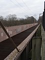
m Replacing Historic_Route_66_&_Route_53_in_Joliet,_IL_south_of_Theodore_Street..JPG with File:Historic_Route_66_&_Route_53_in_Joliet_IL_south_of_Theodore_Street.jpg (by Materialscientist because: [[commons:COM... |
m Fixed Improper Capitalization on Photo Caption. |
||
| Line 56: | Line 56: | ||
This new agency devised a plan to construct channels and canals to reverse the flow of the rivers away from Lake Michigan and divert the contaminated water downstream where it could be diluted as it flowed into the Des Plaines and eventually the Mississippi. |
This new agency devised a plan to construct channels and canals to reverse the flow of the rivers away from Lake Michigan and divert the contaminated water downstream where it could be diluted as it flowed into the Des Plaines and eventually the Mississippi. |
||
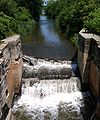
[[Image:Starved Rock Lock (COE) tow downbound.jpg|thumb|300 px|right|New |
[[Image:Starved Rock Lock (COE) tow downbound.jpg|thumb|300 px|right|New lock and dam structures that replaced the historic Illinois and Michigan Canal]] In 1892, the direction of part of the Chicago River was reversed by the [[Army Corps of Engineers]] with the result that the river and much of Chicago's sewage flowed into the canal instead of into [[Lake Michigan]]. The complete reversal of the river's flow was accomplished when the Sanitary and Ship Canal was opened in 1900. |
||
Today much of the canal is a long, thin park with canoeing and a {{convert|62.5|mi|km|adj=on}} hiking and biking trail (constructed on the alignment of the mule tow paths). It also includes museums and historical canal buildings. It was designated the first [[National Heritage Corridor]] by [[Congress of the United States|US Congress]] in 1984. |
Today much of the canal is a long, thin park with canoeing and a {{convert|62.5|mi|km|adj=on}} hiking and biking trail (constructed on the alignment of the mule tow paths). It also includes museums and historical canal buildings. It was designated the first [[National Heritage Corridor]] by [[Congress of the United States|US Congress]] in 1984. |
||
Revision as of 13:13, 18 June 2012
Illinois and Michigan Canal Locks and Towpath | |
 a scene at Seneca, Illinois | |
 | |
| Nearest city | Joliet, Illinois |
|---|---|
| Area | 1,130 acres (4.6 km2)[1] |
| Built | 1848 |
| NRHP reference No. | 66000332 |
| Significant dates | |
| Added to NRHP | October 15, 1966[2] |
| Designated NHL | January 29, 1964[3] |
The Illinois and Michigan Canal ran 96 miles (154 km) from the Bridgeport neighborhood in Chicago on the Chicago River to LaSalle-Peru, Illinois, on the Illinois River. It was finished in 1848 when Chicago Mayor James Hutchinson Woodworth presided over its opening; and it allowed boat transportation from the Great Lakes to the Mississippi River and the Gulf of Mexico. The canal enabled navigation across the Chicago Portage and helped establish Chicago as the transportation hub of the United States, opening before railroads were laid in the area. Its function was largely replaced by the wider and shorter Chicago Sanitary and Ship Canal in 1900 and it ceased transportation operations in 1933.
Illinois and Michigan Canal Locks and Towpath, a collection of eight engineering structures and segments of the canal between Lockport and LaSalle-Peru, was designated a National Historic Landmark in 1964.[1][3]
Portions of the canal have been filled in.[1] Much of the former canal has been preserved as part of the Illinois and Michigan Canal National Heritage Corridor.
History

In 1824, Samuel D. Lockwood, one of the first commissioners of the canal, was given the authorization to hire contractors to survey a route for the canal to follow.[4]
Construction on the canal began in 1836, although it was stopped for several years due to an Illinois state financial crisis related to the Panic of 1837. The Canal Commission had a grant of 284,000 acres ([convert: unit mismatch]) of federal land which it sold at $1.25 per acre (309 $/km²) to finance the construction. Still, money had to be borrowed from eastern U.S. and British investors to finish the canal.
Most of the canal work was done by Irish immigrants who previously worked on the Erie Canal. The work was considered dangerous and many workers died, although no official records exist to indicate how many. The Irish immigrants who toiled to build the canal were often derided as a sub-class and were treated very poorly by other citizens of the city.
The canal was finished in 1848 with a total cost of $6,170,226. Pumps were used to draw water to fill the canal near Chicago, soon supplemented by the Calumet Feeder Canal, and the DuPage River supplied water farther south. In 1871 the canal was deepened to speed up the current and to improve sewage disposal.
The canal was eventually 60 feet (20 m) wide and six feet (2 m) deep, with paths constructed along each edge to permit mules to be harnessed to tow barges along the canal. Towns were planned out along the path of the canal spaced at intervals corresponding to the length that the mules could haul the barges. It had seventeen locks and four aqueducts to cover the 140 foot (45 m) height difference between Lake Michigan and the Illinois River. From 1848 to 1852 the canal was a popular passenger route, but this ended in 1853 with the opening of the Chicago, Rock Island and Pacific Railroad that ran parallel to the canal. The canal had its peak shipping year in 1882 and remained in use until 1933. It was replaced in 1900 by the larger Chicago Sanitary and Ship Canal, which remains in use.
-
 Fox River Aqueduct in Ottawa, IL
 -
 Aux Sable Creek Aqueduct, Morris, IL
 -
 Locktenders House and lock at the Aux Sable Creek
 -
 Goose Lake Priarie F&WA, Morris, IL
 -
 Lock #3, Lockport, IL
 -

.JPG)


Experiencing a remarkable recovery from the devastating fire of 1871, Chicago rebuilt rapidly along the shores of the Chicago River. The river was especially important to the development of the city since all wastes from houses, farms, the stockyards, and other industries could be dumped into the river and carried out into Lake Michigan.
The lake, however, was also the source of drinking water. During a tremendous storm in 1885, the rainfall washed refuse from the river, especially from the highly polluted Bubbly Creek, far out into the lake (the city water intakes are located 2 miles (3.2 km) offshore). Although no epidemics occurred, the Chicago Sanitary District (now The Metropolitan Water Reclamation District) was created by the Illinois legislature in 1889 in response to this close call.[5]
This new agency devised a plan to construct channels and canals to reverse the flow of the rivers away from Lake Michigan and divert the contaminated water downstream where it could be diluted as it flowed into the Des Plaines and eventually the Mississippi.
_tow_downbound.jpg)
In 1892, the direction of part of the Chicago River was reversed by the Army Corps of Engineers with the result that the river and much of Chicago's sewage flowed into the canal instead of into Lake Michigan. The complete reversal of the river's flow was accomplished when the Sanitary and Ship Canal was opened in 1900.
Today much of the canal is a long, thin park with canoeing and a 62.5-mile (100.6 km) hiking and biking trail (constructed on the alignment of the mule tow paths). It also includes museums and historical canal buildings. It was designated the first National Heritage Corridor by US Congress in 1984.
From east to west the towns along the path of the canal include:
- Bridgeport (Chicago neighborhood)
- Summit
- Willow Springs
- Lemont
- Romeoville
- Lockport
- Joliet
- Channahon
- Morris
- Seneca
- Marseilles
- Ottawa
- Utica
- LaSalle
- Peru
See also
- Matthew Laflin
- Metropolitan Water Reclamation District of Greater Chicago
- Treaty of St. Louis
- Shabbona Trail includes 20 miles (32 km) of the Illinois and Michigan Canal Trail.
- Channahon State Park
- Gebhard Woods State Park
- The Volunteer (canal boat)
- David Leavitt (banker)
References
- ^ a b c Blanche Schroer, Grant Peterson, and S. Sydney Bradford (September 14, 1975). "National Register of Historic Places Inventory-Nomination: Illinois and Michigan Canal" (Document). National Park Service.
{{cite document}}: Unknown parameter|accessdate=ignored (help); Unknown parameter|format=ignored (help); Unknown parameter|url=ignored (help)CS1 maint: multiple names: authors list (link) and Template:PDFlink - ^ "National Register Information System". National Register of Historic Places. National Park Service. January 23, 2007.
- ^ a b "Illinois and Michigan Canal Locks and Towpath". National Historic Landmark summary listing. National Park Service. Retrieved 2007-10-11.
- ^ Coffin, William (1889). Life and Times of Hon. Samuel D. Lockwood. Chicago, IL: Knight & Leonard Co. p. 41.
- ^ The Straight Dope: Did 90,000 people die of typhoid fever and cholera in Chicago in 1885?
Edward Ranney & Emily Harris. (1998). Prairie Passage: The Illinois and Michigan Canal Corridor. Urbana, IL: University of Illinois Press.
External links
- Illinois & Michigan Canal National Heritage Corridor at U.S. National Park Service
- Canal Corridor Association
- Canal and Regional History Special Collection at Lewis University
- Illinois & Michigan Canal State Trail
- Chicago Historical Society: Illinois & Michigan Canal
- The Illinois and Michigan Canal, 1827–1911: A Selection of Documents from the Illinois State Archives
- Metropolitan Water Reclamation District of Greater Chicago
- Ottawa Visitors Center
- Will County Historical Society, housed in original Canal Office
| Topics | |
|---|---|
| Lists by state |
|
| Lists by insular areas | |
| Lists by associated state | |
| Other areas | |
| Related | |