
Štrbački buk
| Štrbački buk | |
|---|---|
 | |
 | |
| Elevation | 294 metres (965 ft)[1] |
| Total height | 24 metres (79 ft)[1] |
| Watercourse | Una River |
The Štrbački buk waterfalls are on the Una River, spanning the border between Bosnia and Herzegovina and Croatia. The closest settlements to the waterfalls are the villages of Donji Štrbci and Kestenovac on the Croatian side, and the villages of Doljani and Ćukovi on the Bosnian side.
Štrbački buk and complex of the Una waterfalls at Martin Brod, along with the Unac River and its canyon, and the Una itself, are the main natural features of Una National Park in Bosnia and Herzegovina.
-
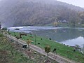 above Štrbački buk
 -
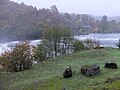 above Štrbački buk
 -
 Štrbački buk
 -
 Štrbački buk
 -
 Štrbački buk


References
External links
![]() Media related to Štrbački buk at Wikimedia Commons
Media related to Štrbački buk at Wikimedia Commons

Hydrography of Croatia | ||||||
|---|---|---|---|---|---|---|
| Rivers |
|  | ||||
| Lakes | ||||||
| Valleys, estuaries, canyons, wetlands | ||||||
| Waterfalls | ||||||
| Canals |
| |||||
| Adriatic Sea | ||||||
44°39′28″N 16°00′17″E / 44.657765°N 16.00467°E
This Lika-Senj County geography article is a stub. You can help Wikipedia by expanding it. |
This Una-Sana Canton geography article is a stub. You can help Wikipedia by expanding it. |