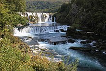
Štrbački buk
Appearance
| Štrbački buk | |
|---|---|
 | |
 | |
| Elevation | 296 metres (971 ft)[1] |
| Total height | 25 metres (82 ft)[1] |
| Watercourse | Una River |
Strbacki buk waterfall is a 25 m high waterfall on the Una River (296 m altitude). It is situated on the border between Croatia (Lika-Senj County, city Donji Lapac, settlement Kestenovac) and Bosnia and Herzegovina (Una-Sana Canton, city Bihać, settlement Doljani and Celije). On Croatian side, „Una Mamea Park“ is located and on Bosnian and Herzegovinian „Una National Park“.
References
External links
![]() Media related to Štrbački buk at Wikimedia Commons
Media related to Štrbački buk at Wikimedia Commons
44°39′28″N 16°00′17″E / 44.657765°N 16.00467°E


