86th Street station (IRT Lexington Avenue Line)
86th Street | |||||||||||||||||||||||||
|---|---|---|---|---|---|---|---|---|---|---|---|---|---|---|---|---|---|---|---|---|---|---|---|---|---|
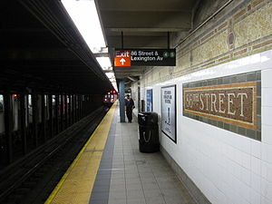
 Local downtown platform | |||||||||||||||||||||||||
| Station statistics | |||||||||||||||||||||||||
| Address | East 86th Street & Lexington Avenue New York, NY 10028 | ||||||||||||||||||||||||
| Borough | Manhattan | ||||||||||||||||||||||||
| Locale | Upper East Side | ||||||||||||||||||||||||
| Coordinates | 40°46′46″N 73°57′20″W / 40.779469°N 73.955626°W | ||||||||||||||||||||||||
| Division | A (IRT)[1] | ||||||||||||||||||||||||
| Line | IRT Lexington Avenue Line | ||||||||||||||||||||||||
| Services | 4 5 6 | ||||||||||||||||||||||||
| Transit | |||||||||||||||||||||||||
| Structure | Underground | ||||||||||||||||||||||||
| Levels | 2 | ||||||||||||||||||||||||
| Platforms | 4 side platforms (2 on each level) | ||||||||||||||||||||||||
| Tracks | 4 (2 on each level) | ||||||||||||||||||||||||
| Other information | |||||||||||||||||||||||||
| Opened | July 17, 1918 | ||||||||||||||||||||||||
| Opposite- direction transfer | No | ||||||||||||||||||||||||
| Traffic | |||||||||||||||||||||||||
| 2023 | 10,472,358[2] | ||||||||||||||||||||||||
| Rank | 18 out of 423[2] | ||||||||||||||||||||||||
| Station succession | |||||||||||||||||||||||||
| Next north | Template:NYCS next Template:NYCS next | ||||||||||||||||||||||||
| Next south | Template:NYCS next Template:NYCS next | ||||||||||||||||||||||||
| |||||||||||||||||||||||||
| |||||||||||||||||||||||||
| |||||||||||||||||||||||||
86th Street is an express station on the IRT Lexington Avenue Line of the New York City Subway. Located at the intersection of Lexington Avenue and 86th Street on the Upper East Side, it is served by the 4 and 6 trains at all times, the 5 train at all times except late nights on weekdays, and the <6> during weekdays in peak direction.
History
86th Street opened on July 17, 1918 as part of an expansion of the IRT Lexington Avenue Line north of Grand Central–42nd Street.[5]
This station underwent three renovations. The first took place with the opening of a Gimbels department store directly above in the early 1970s. The renovation took place mostly in the fare control areas. The second renovation was completed by 1986 as part of a move to prevent the existing New York City Subway stations from falling apart after years of deferred maintenance; this is evidenced by the addition of the then standard orange platform edge in addition to the yellow platform edge that was originally there, as well as painting the I Beams red instead of the original blue and fixing all the other parts of the station.[6] The third renovation was completed by Fall 2004.[7] It consisted of repainting the I beams from red to dark blue, as well as the removal of train arrival devices on the upper level that gave notices of approaching express trains on the lower level, among other things; the latter were replaced with countdown clocks, on both levels, which performed the same function.[8][9]
Station layout
| G | Street Level | Exit/Entrance |
| B1 Local platforms |
East Mezzanine | Exits/Entrances to northbound platforms |
| Side platform, doors will open on the right | ||
| Northbound local | ← ← | |
| Southbound local | → | |
| Side platform, doors will open on the right | ||
| West Mezzanine | Exits/Entrances to southbound platforms | |
| B2 Express platforms |
Side platform, doors will open on the right | |
| Northbound express | ← ← | |
| Southbound express | → → | |
| Side platform, doors will open on the right | ||
| style="color:;background:#Template:NYCS color;text-align:center;padding:5px"| Track layout | |||||||||||||||||||||||||||||||||||||||||||||||||||||||||||||||||||||||||||||
|---|---|---|---|---|---|---|---|---|---|---|---|---|---|---|---|---|---|---|---|---|---|---|---|---|---|---|---|---|---|---|---|---|---|---|---|---|---|---|---|---|---|---|---|---|---|---|---|---|---|---|---|---|---|---|---|---|---|---|---|---|---|---|---|---|---|---|---|---|---|---|---|---|---|---|---|---|---|
Upper level
| |||||||||||||||||||||||||||||||||||||||||||||||||||||||||||||||||||||||||||||
| |||||||||||||||||||||||||||||||||||||||||||||||||||||||||||||||||||||||||||||
Lower level
| |||||||||||||||||||||||||||||||||||||||||||||||||||||||||||||||||||||||||||||
| |||||||||||||||||||||||||||||||||||||||||||||||||||||||||||||||||||||||||||||
This underground station has two levels. Each level has two tracks and two side platforms. The upper level serves local trains while the lower level serves express trains. There is no express service during late nights and the lower level is closed during that period.[10] Three staircases connect the levels on each side.
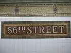
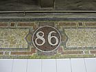
There are no crossovers or crossunders between the platforms, making this one of only three express stations in the system where free transfers between opposite directions are not possible (the other is Nostrand Avenue on the IND Fulton Street Line, and Bergen Street, whose lower level is closed, on the IND Culver Line). Each platform has its original Dual Contracts trim line consisting mostly of yellows and browns. Small "86" tablets in a circle run along this trim line.[11] The name tablets have "86TH STREET" in white Times New Roman font on a reddish-brown background with a light-brown inner border and green outer border.[12] Teal columns run along all four platforms at regular intervals.[13]
Each upper level platform has one same-level fare control area in the center. The southbound side has a turnstile bank, token booth, two staircases going up to southwest corner of East 86th Street and Lexington Avenue, and two more that are built inside a Best Buy store on the northwest corner of the same intersection.[14] The northbound fare control has an unstaffed turnstile bank and two staircases going up to the southeast corner of East 86th Street and Lexington Avenue. Two more staircases are built inside a shopping arcade that is in the basement of a former Petco store on the northeast corner of the same intersection. The building is currently occupied by other businesses.[15]
The 2004 artwork here is called Happy City by Peter Sis. It consists of four different glass and etched stone mosaic murals in the shapes of huge eyes surrounded by various animals and objects. They are located at each top of the four staircases near the fare control areas that go down to the lower level express platforms.[16]
This station was added to the National Register of Historic Places on March 30, 2005.[17]
Exits
| Exit location[18] | Exit type | Number of exits | Platform served |
|---|---|---|---|
| NW corner of Lexington Avenue and 86th Street | Staircase | 2 | Southbound |
| SW corner of Lexington Avenue and 86th Street | Staircase | 2 | Southbound |
| NE corner of Lexington Avenue and 86th Street | Staircase | 2 | Northbound |
| SE corner of Lexington Avenue and 86th Street | Staircase | 2 | Northbound |
Notable places nearby
- Church of St. Ignatius Loyola[18]
- Cooper–Hewitt, National Design Museum[18]
- Metropolitan Museum of Art[18]
- National Academy of Design[18]
- Neue Galerie New York[18]
- Regis High School[18]
- Solomon R. Guggenheim Museum[18]
References
- ^ "Glossary". Second Avenue Subway Supplemental Draft Environmental Impact Statement (SDEIS) (PDF). Vol. 1. Metropolitan Transportation Authority. March 4, 2003. pp. 1–2. Archived from the original (PDF) on February 26, 2021. Retrieved January 1, 2021.
- ^ a b "Annual Subway Ridership (2018–2023)". Metropolitan Transportation Authority. 2023. Retrieved April 20, 2024.
- ^ "NPS Focus". National Register of Historic Places. National Park Service. Retrieved November 6, 2011.
- ^ "Annual Subway Ridership (2018–2023)". Metropolitan Transportation Authority. 2023. Retrieved April 20, 2024.
- ^ "Lexington Av. Line to be Opened Today — Subway Service to East Side of Harlem and the Bronx Expected to Relieve Congestion — Begins With Local Trains — Running of Express Trains to Await Opening of Seventh Avenue Line of H System". The New York Times. July 17, 1918. p. 13. Retrieved November 11, 2016.
{{cite news}}: Cite has empty unknown parameter:|dead-url=(help) - ^ http://www.nycsubway.org/perl/show?65601
- ^ Jeremiah Cox. "86 Street (4,5,6) - The SubwayNut". subwaynut.com.
- ^ "Learn More about Countdown Clocks..." Metropolitan Transportation Authority. Retrieved October 31, 2011.
- ^ "Countdown Clocks Station List". Metropolitan Transportation Authority. Retrieved October 31, 2011.
- ^ Dougherty, Peter (2006) [2002]. Tracks of the New York City Subway 2006 (3rd ed.). Dougherty. OCLC 49777633 – via Google Books.
- ^ Cox, Jeremiah (August 15, 2008). "Close-up of 86 in the trimline". subwaynut.com. Retrieved August 4, 2017.
{{cite web}}: Cite has empty unknown parameter:|dead-url=(help) - ^ Cox, Jeremiah (August 12, 2011). "A name tablet". subwaynut.com. Retrieved August 4, 2017.
{{cite web}}: Cite has empty unknown parameter:|dead-url=(help) - ^ Cox, Jeremiah (August 15, 2008). "Passengers get off a downtown 6 train". subwaynut.com. Retrieved August 4, 2017.
{{cite web}}: Cite has empty unknown parameter:|dead-url=(help) - ^ Cox, Jeremiah (August 12, 2011). "One of the entrances inside the storefront of Best Buy". subwaynut.com. Retrieved August 4, 2017.
{{cite web}}: Cite has empty unknown parameter:|dead-url=(help) - ^ Cox, Jeremiah (August 12, 2011). "A downtown subway entrance and to the shopping arcade, the globes support is still unpainted generally there green". subwaynut.com. Retrieved August 4, 2017.
{{cite web}}: Cite has empty unknown parameter:|dead-url=(help) - ^ "MTA - Arts & Design | NYCT Permanent Art". web.mta.info. Retrieved August 4, 2017.
{{cite web}}: Cite has empty unknown parameter:|dead-url=(help) - ^ "National Register of Historical Places - NEW YORK (NY), New York County". www.nationalregisterofhistoricplaces.com. Retrieved August 4, 2017.
{{cite web}}: Cite has empty unknown parameter:|dead-url=(help) - ^ a b c d e f g h "MTA Neighborhood Maps: Upper East Side" (PDF). mta.info. Metropolitan Transportation Authority. 2016. Retrieved December 30, 2016.
External links
- nycsubway.org – IRT East Side Line: 86th Street
- nycsubway.org — Happy City Artwork by Peter Sis (2004)
- MTA's Arts For Transit — 86th Street (IRT Lexington Avenue Line)
- 86th Street northbound entrance from Google Maps Street View
- 86th Street southbound entrance from Google Maps Street View
- Platforms from Google Maps Street View


