Siksika 146
Appearance
Siksika 146 | |
|---|---|
| Siksika Indian Reserve No. 146 | |
 Location in Alberta | |
| First Nation | Siksika Nation |
| Country | Canada |
| Province | Alberta |
| Municipal districts | Vulcan Wheatland |
| Headquarters | Gleichen |
| Area | |
| • Land | 701.96 km2 (271.03 sq mi) |
| Population (2016)[1] | |
• Total | 3,479 |
| • Density | 4.96/km2 (12.8/sq mi) |
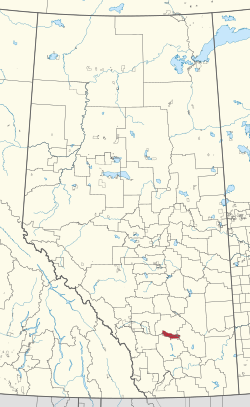
Siksika 146 is a First Nations reserve in southern Alberta, Canada.[2] It has a land area of 696.54 km2, making it the second-largest Indigenous reserve in Canada (after Blood 148, Alberta). It is located 87 kilometres (54 mi) southeast of Calgary and is inhabited by members of the Siksika Nation. It is bordered by Vulcan County, Wheatland County, and the County of Newell, and is located at an elevation of 857 metres (2,812 ft). The Canada 2011 Census reported a population of 2,972 inhabitants. The reserve is home to the Blackfoot Crossing historical park.
External links
References
- ^ a b "Census Profile, 2016 Census". Statistics Canada. February 8, 2017. Retrieved 2019-08-10.
- ^ "Siksika 146". Statistics Canada. 2001. Retrieved 6 January 2010.
50°47′N 112°55′W / 50.783°N 112.917°W

