Broaghnabinnia
Appearance
| Broaghnabinnia | |
|---|---|
| Bruach na Binne | |
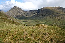
 Bridia Valley, with Broaghnabinnia on the left | |
| Highest point | |
| Elevation | 745 m (2,444 ft)[1] |
| Prominence | 290 m (950 ft)[1] |
| Listing | Marilyn, Hewitt |
| Coordinates | 51°58′19.2″N 9°44′38.4″W / 51.972000°N 9.744000°W |
| Naming | |
| English translation | Verge of the peak |
| Language of name | Irish |
| Geography | |
| Parent range | Dunkerron Mountains (Mountains of the Iveragh Peninsula) |
| OSI/OSNI grid | V801814 |
| Climbing | |
| Easiest route | scrambling |
Broaghnabinnia (Irish: Bruach na Binne, meaning 'verge of the peak'[2]) is a summit of the Dunkerron Mountains, part of the Mountains of the Iveragh Peninsula[3] in County Kerry, Ireland.
Geography
The mountain lies northeast of Stumpa Dúloigh, the highest mountain of the Dunkerron range. With an elevation of 745 metres it is the 80th highest summit in Ireland.[citation needed]

Access to the summit
Broaghnabinnia summit can be accessed scrambling, and is steep on all sides.[1]
References
- ^ a b c "Dunkerron Mountains Area / Broaghnabinnia". MountainViews.ie. Ordnance Survey Ireland. Retrieved 9 June 2015.
- ^ Paul Tempan. "Irish Hill and Mountain Names" (PDF). Mountaineering.ie. Mountaineering Ireland. Retrieved 9 June 2015.
- ^ "Hills and Mountains of Britain and Ireland - Ireland : Iveragh Peninsula". www.walkingclub.org.uk. Saturday Walkers Club. Archived from the original on 11 October 2013. Retrieved 9 June 2015.


