Duclair
Appearance
Duclair | |
|---|---|
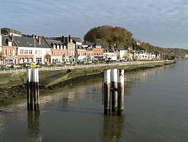
 The Seine riverside at Duclair | |
| Coordinates: 49°29′08″N 0°52′34″E / 49.4856°N 0.8761°E | |
| Country | France |
| Region | Normandy |
| Department | Seine-Maritime |
| Arrondissement | Rouen |
| Canton | Barentin |
| Intercommunality | Métropole Rouen Normandie |
| Government | |
| • Mayor (2020–2026) | Jean Delalandre[1] |
| Area 1 | 10.02 km2 (3.87 sq mi) |
| Population (2021)[2] | 4,020 |
| • Density | 400/km2 (1,000/sq mi) |
| Time zone | UTC+01:00 (CET) |
| • Summer (DST) | UTC+02:00 (CEST) |
| INSEE/Postal code | 76222 /76480 |
| Elevation | 1–122 m (3.3–400.3 ft) (avg. 10 m or 33 ft) |
| 1 French Land Register data, which excludes lakes, ponds, glaciers > 1 km2 (0.386 sq mi or 247 acres) and river estuaries. | |
Duclair (French pronunciation: [dyklɛʁ]) is a commune in the Seine-Maritime department in the Normandy region in northern France.[3] The Duclair duck is named after the town.
Geography
Duclair is a farming and light industrial town situated some 11 miles (18 km) west of the centre of Rouen at the junction of the D43, D5 and the D982 roads. The river Austreberthe joins the Seine at Duclair.[4] There is a ferry to Berville-sur-Seine on the south bank of the Seine.
Heraldry
 |
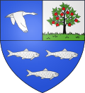
The arms of Duclair are blazoned : Per fess 1: per pale I: Azure, a duck volant contourny both wings pointing down argent; II: Or, an apple tree fructed proper on a base vert; 2: Azure, 3 fish contourny argent.
|
Population
| Year | Pop. | ±% p.a. |
|---|---|---|
| 1968 | 2,705 | — |
| 1975 | 2,975 | +1.37% |
| 1982 | 3,487 | +2.29% |
| 1990 | 3,822 | +1.15% |
| 1999 | 4,163 | +0.95% |
| 2007 | 4,094 | −0.21% |
| 2012 | 4,094 | +0.00% |
| 2017 | 4,198 | +0.50% |
| Source: INSEE[5] | ||
Places of interest
- The church of St. Denis, dating to the 12th century.
- Traces of a feudal castle.
- Remains of a 13th-century presbytery.
- The Château du Taillis, dating to medieval times.
- The 18th-century Château du Vaurouy.
- La Cour-du-Mont manor house with parts dating to the 13th century.
- A 17th-century chapel.

Notable people
- Musician Pierre Villette (1926–1998) was born here.
Twin towns
See also
References
- ^ "Répertoire national des élus: les maires". data.gouv.fr, Plateforme ouverte des données publiques françaises (in French). 2 December 2020.
- ^ "Populations légales 2021" (in French). The National Institute of Statistics and Economic Studies. 28 December 2023.
- ^ Commune de Duclair (76222), INSEE
- ^ Sandre. "Fiche cours d'eau - L'Austreberthe (H5060600)".
- ^ Population en historique depuis 1968, INSEE
Bibliography
- Francis Aubert, Duclair, un regard sur le passé, Duclair, 2002 ISBN 2-9519259-0-5
- Ariane Duclert, "Le Caneton à la rouennaise, spécialité de Duclair", Pays de Normandie ISSN 1266-1341
- Gilbert Fromager, Le Canton of Duclair à l'aube du XXe, Duclair, 1986 ISBN 2-9501653-0-3
External links
 Media related to Duclair at Wikimedia Commons
- Official website


