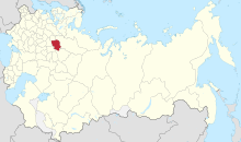
Kostroma Governorate
Appearance
| Kostroma Governorate Костромская губерния | |
|---|---|
| Governorate of Russian Empire | |
| 1796–1929 | |
 Kostroma Governorate within the Russian Empire | |
| Capital | Kostroma |
| History | |
• Established | 1796 |
• Disestablished | 1929 |
Kostroma Governorate (Template:Lang-ru) was an administrative division (a guberniya) of the Russian Empire and the Russian SFSR, which existed from 1796 to 1929. Its administrative center was in the city of Kostroma.
Administrative division
Kostroma Governorate consisted of 12 uyezds (their administrative centres in brackets):
- Buysky Uyezd (Buy)
- Varnavinsky Uyezd (Varnavino)
- Vetluzhsky Uyezd (Vetluga)
- Galichsky Uyezd (Galich)
- Kineshemsky Uyezd (Kineshma)
- Kologrivsky Uyezd (Kologriv)
- Kostromskoy Uyezd (Kostroma)
- Makaryevsky Uyezd (Makaryev)
- Nerekhtsky Uyezd (Nerekhta)
- Soligalichsky Uyezd (Soligalich)
- Chukhlomskoy Uyezd (Chukhloma)
- Yuryevetsky Uyezd (Yuryevets)
History
This section is empty. You can help by adding to it. (January 2014) |
References
- William Henry Beable (1919), "Governments or Provinces of the Former Russian Empire: Kostroma", Russian Gazetteer and Guide, London: Russian Outlook – via Open Library
57°46′00″N 40°56′00″E / 57.7667°N 40.9333°E

