Mirpur Khas District
Mirpur Khas District
ضلع میرپور خاص ميرپور خاص ضلعو | |
|---|---|
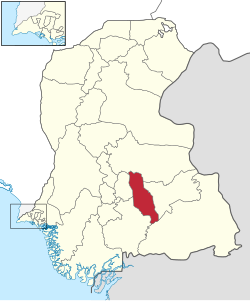
 Location of Mirpurkhas in Sindh province | |
| Coordinates: 25°33′02″N 069°00′11″E / 25.55056°N 69.00306°E | |
| Country | |
| Province | |
| Division | Mirpur Khas |
| Established | 31 October 1990 |
| Headquarters | Mirpur Khas |
| Government | |
| • Type | District Administration |
| • Deputy Commissioner | Zain Ul Abideen Memon |
| • District Police Officer | N/A |
| • District Health Officer | N/A |
| Area | |
| • Total | 2,925 km2 (1,129 sq mi) |
| Population (2017)[1] | |
| • Total | 1,504,440 |
| • Density | 510/km2 (1,300/sq mi) |
| Time zone | UTC+5 (PST) |
| Number of Tehsils | 7 |
Mirpur Khas District (Sindhi: ضلعو ميرپورخاص, Urdu: ضلع مِيرپورخاص) is one of the districts in the province of Sindh, Pakistan. Its capital is Mirpur Khas.
Administrative divisions
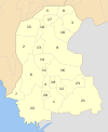
The district of Mirpur Khas is sub-divided into 7 tehsils:
- Digri Tehsil
- Kot Ghulam Muhammad Tehsil
- Mirpur Khas Tehsil
- Jhuddo Tehsil
- Sindhri Tehsil
- Hussain Bux Mari Tehsil
- Shujabad Tehsil
History

After the capture of Sindh by the British, In 1882 they created Thar and Parkar District in Southeastern Sindh for administrative purposes. In 1906, the district headquarters was moved from Amarkot (now Umerkot) to Mirpur Khas. In 1953, after the creation of Pakistan, some area on the northern side was detached from the original Tharparkar District and named Sanghar District. On 31 October 1990 the district was divided into the Tharparkar and Mirpur Khas Districts. In the same year, Mirpurkhas also get the status of divisional headquarter.
Mirpur Khas District derives its name from the town of Mirpur Khas, founded by Mir Ali Murad Talpur in 1806.
Demographics
At the time of the 2017 census, Mirpur Khas district had a population of 1,504,440, of which 434,081 (28.85%) lived in urban areas. Mirpur Khas had a sex ratio of 938 females per 1000 males and a literacy rate of 42.41%: 52.94% for males and 31.22% for females.[1]
Religion
The majority religion is Islam, with 60.75% of the population. Hinduism (including those from Scheduled Castes) is practiced by 38.74% of the population. In rural areas, Muslims and Hindus are in nearly equal numbers.[1]
| Circle | Muslims | Hindus | Others |
|---|---|---|---|
| Digri | 59.76% | 40.13% | 0.11% |
| Hussain Bux Mari | 61.24% | 38.60% | 0.16% |
| Jhudo | 56.68% | 42.92% | 0.40% |
| Kot Ghulam Muhammad | 45.37% | 54.51% | 0.12% |
| Mirpur Khas | 89.04% | 9.03% | 1.93% |
| Shujabad | 52.27% | 47.29% | 0.44% |
| Sindhri | 57.51% | 42.43% | 0.06% |
Language
At the time of the 2017 census, 75.78% of the population spoke Sindhi, 12.23% Urdu, 7.48% Punjabi and 1.25% Balochi as their first language.[1]
List of Dehs
The following is a list of Mirpur Khas District's dehs, organised by taluka:[3]
- Mirpur Khas Tehsil (2 Dehs)
- Digri Tehsil (69 Dehs)
- Deh 141
- Deh 142
- Deh 143-Abadgar
- Deh 144
- Deh 144-A
- Deh 146-Leghari
- Deh 147
- Deh 148
- Deh 149
- Deh 150
- Deh 151
- Deh 152
- Deh 153-Pabban
- Deh 154
- Deh 155
- Deh 156
- Deh 157
- Deh 158
- Deh 159
- Deh 160
- Deh 161
- Deh 161-A
- Deh 162-Mir Mohammad Hassan
- Deh 162-A
- Deh 163
- Deh 164
- Deh 165-Sonhari
- Deh 166
- Deh 167
- Deh 168
- Deh 169-Digri
- Deh 170
- Deh 171
- Deh 172
- Deh 173
- Deh 174
- Deh 175-Abring
- Deh 176
- Deh 177
- Deh 178
- Deh 179-Mehar
- Deh 180
- Deh 181
- Deh 182
- Deh 183
- Deh 184
- Deh 185
- Deh 186
- Deh 187
- Deh 188
- Deh 189
- Deh 190-Qazi Ashraf
- Deh 191
- Deh 192
- Deh 193
- Deh 194
- Deh 195
- Deh 196
- Deh 197
- Deh 198-Basran
- Deh 198-A
- Deh 199
- Deh 200
- Deh 201
- Deh 204
- Deh 206
- Deh 262
- Deh 263
- Deh 265
- Hussain Bux Mari Tehsil (47 Union councils)
- Deh 71-Sikanderabad
- Deh 77
- Deh 78-Sakho
- Deh 79-Patoyoon
- Deh 79-A
- Deh 80
- Deh 81
- Deh 81-A
- Deh 82-A
- Deh 87-M. H. Mari
- Deh 88
- Deh 89
- Deh 90
- Deh 91-Khan
- Deh 92
- Deh 93
- Deh 94-Miro Mari
- Deh 95-Khudri
- Deh 96
- Deh 97
- Deh 98
- Deh 99
- Deh 100-Pir Azeem Shah
- Deh 101-Mirpurkhas
- Deh 102
- Deh 103
- Deh 104
- Deh 105-Bhitaro
- Deh 106
- Deh 107
- Deh 108
- Deh 109
- Deh 110
- Deh 111-Mirpur Old
- Deh 112
- Deh 113
- Deh 114
- Deh 115
- Deh 116
- Deh 117
- Deh 118-Veesro
- Deh 119
- Deh 120
- Deh 121
- Deh 122
- Deh 123
- Deh 125
- Jhudo Tehsil (63 Dehs)
- Deh 202-Mir Khuda Bux
- Deh 203
- Deh 205
- Deh 264
- Deh 309-Bandwari
- Deh 310
- Deh 311
- Deh 312
- Deh 313-Jhudo
- Deh 314
- Deh 315
- Deh 316
- Deh 317
- Deh 318-Roshanabad
- Deh 318-A
- Deh 319-Mir Malik Mohammad
- Deh 319-A
- Deh 319-B
- Deh 319-C
- Deh 340-Gunero
- Deh 341
- Deh 341-A
- Deh 342
- Deh 343-Karam Ali
- Deh 344
- Deh 344-A
- Deh 345-A
- Deh 352
- Deh 353
- Deh 354
- Deh 354-A
- Deh 355
- Deh 356
- Deh 357
- Deh 358-Bakhar
- Deh 358-A
- Deh 359-Bilalani
- Deh 360
- Deh 362
- Deh 363
- Deh 365
- Deh 366
- Deh 366-A
- Deh 367
- Deh 367-A
- Deh 368
- Deh 368-A
- Deh 369
- Deh 370
- Deh 370-A
- Deh 371
- Deh 372
- Deh 373
- Deh 373-A
- Deh 374
- Deh 375
- Deh 376
- Akhuto
- Athela
- Dehti
- Janhan
- Samroti
- Udhejani
- Kot Ghulam Muhammad Bhurgri Tehsil (113 Dehs)
- Deh 208-Tagi
- Deh 209
- Deh 210-Kalwari
- Deh 211
- Deh 212
- Deh 213
- Deh 214-Murad Shah
- Deh 215
- Deh 216
- Deh 219
- Deh 221-Dengan
- Deh 222
- Deh 223
- Deh 230
- Deh 231
- Deh 232
- Deh 233
- Deh 234
- Deh 235
- Deh 251-Chanuro
- Deh 252
- Deh 253
- Deh 254-Gorchani
- Deh 255
- Deh 256-Wagherji
- Deh 257
- Deh 258
- Deh 259-Sodha Bore
- Deh 260-Khudabad
- Deh 261
- Deh 266
- Deh 267
- Deh 268
- Deh 268-A
- Deh 269
- Deh 270
- Deh 270-A
- Deh 271
- Deh 272
- Deh 273
- Deh 274
- Deh 274-A
- Deh 275
- Deh 276
- Deh 277
- Deh 278
- Deh 279
- Deh 279-A
- Deh 280
- Deh 281
- Deh 282
- Deh 283
- Deh 284
- Deh 285
- Deh 286-Rajwah
- Deh 287
- Deh 288
- Deh 289
- Deh 290
- Deh 290-A
- Deh 291
- Deh 292
- Deh 293
- Deh 294-Sakari
- Deh 295
- Deh 296
- Deh 297
- Deh 298
- Deh 299-Lal Shah
- Deh 300
- Deh 301
- Deh 301-A
- Deh 302
- Deh 303
- Deh 303-A
- Deh 304-Kario Pipar
- Deh 304-A
- Deh 305
- Deh 306
- Deh 307
- Deh 308
- Deh 308-A
- Deh 320
- Deh 320-A
- Deh 320-B
- Deh 321
- Deh 322
- Deh 322-A
- Deh 323
- Deh 324
- Deh 328-Chach
- Deh 328-A
- Deh 329
- Deh 330-Berani
- Deh 331
- Deh 332
- Deh 333
- Deh 334
- Deh 335
- Deh 336
- Deh 337-Jalalabad
- Deh 338
- Deh 339-Jawariasar
- Deh 339-A
- Deh 345
- Deh 346
- Deh 347
- Deh 348
- Deh 348-A
- Deh 349
- Deh 349-A
- Deh 350
- Deh 351
- Shujabad Tehsil (45 Dehs)
- Deh 107-A
- Deh 140
- Deh 145
- Deh 217
- Deh 224
- Deh 225
- Deh 236
- Deh 237
- Deh 238
- Deh 239
- Deh 243
- Deh 244
- Deh 245
- Deh 246
- Deh 247
- Deh 248
- Deh 249
- Deh 250
- Deh 377-Dolatpur
- Deh 378
- Deh 379
- Deh 380
- Deh 381
- Deh 382
- Deh 383
- Deh 384
- Deh 385
- Belaro
- Boorji
- Chahoo
- Chand Morio
- Chelaro
- Dhanghki
- Kak
- Kantrai
- Khandar
- Khumbri
- Manjri
- Mirwah
- Mubarak
- Pannonundani
- Phadro
- Sangro
- Seri
- Toori
- Sindhri Taluka (76 dehs)
- Deh 72-Chitori
- Deh 73
- Deh 74-Khirah
- Deh 75
- Deh 76
- Deh 124
- Deh 126
- Deh 127
- Deh 128-Kathri
- Deh 129
- Deh 130
- Deh 131
- Deh 132
- Deh 133
- Deh 134
- Deh 135
- Deh 136-Jhurbi
- Deh 137
- Deh 138
- Deh 226
- Deh 227
- Deh 228
- Deh 229
- Deh 240
- Deh 241
- Deh 242
- Allah Bux Mari
- Allah Khani
- Ameen Aukar
- Assassar
- Atna
- Bhanusar
- B-Khirah
- Chari Bux Pahore
- Chari Manglan
- C-Potho
- Dahoro No. 1
- Dahroro No. 2
- Dhair Mitho Faqir
- D-Khandar
- Dobto
- Fateh Muhammad Mashakh
- Ganbo Faqir
- Gichar
- Girhore Sharif
- Halepotani
- Hanjarhadi
- Hingorno
- Jamilani
- Kahroro
- Kakeji
- Kander
- Kangal
- Kani Maghrio
- Khani Maghrio
- Kheer Tarai
- Laiqpur
- Liyari
- Lund
- Malook Halepoto
- Nindo Junejo
- Palango
- Phulahdyun
- Potho
- Rawatro
- Saidki
- Saifal No. 1
- Saifal No. 2
- Sain dad Chhoro
- Sarhal
- Sarhari
- Sindhri
- Tagusar
- Talho Junejo
- Walwari
- Warariyon
See also
References
- ^ a b c d e "District-wise tables: Mirpur Khas". pbs.gov.pk. Pakistan Bureau of Statistics. 2017.
- ^ Menon, Sunita. "Queen of Mangoes: Sindhri from Pakistan now in UAE". Khaleej Times. Retrieved 2019-09-22.
- ^ "List of Dehs in Sindh" (PDF). Sindh Zameen. Retrieved 24 March 2021.
External links


