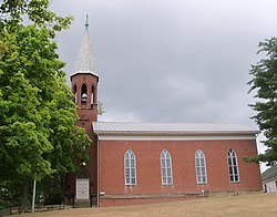
Dungannon, Columbiana County, Ohio
Appearance
Dungannon, Ohio | |
|---|---|
 St. Philip Neri Catholic Church | |
| Coordinates: 40°44′03″N 80°52′43″W / 40.73417°N 80.87861°W | |
| Country | United States |
| State | Ohio |
| County | Columbiana |
| Township | Hanover |
| Elevation | 1,122 ft (342 m) |
| Time zone | UTC-5 (Eastern (EST)) |
| • Summer (DST) | UTC-4 (EDT) |
| ZIP code | 44423 |
| Area code(s) | 330, 234 |
| GNIS Feature ID | 1064567[1] |
Dungannon is an unincorporated community in Hanover Township, Columbiana County, Ohio, United States.[1]
History
Dungannon was laid out in 1835 by George Sloan when the Sandy and Beaver Canal was extended to that point. He named the community after Dungannon, Northern Ireland, his native home.[2]
A post office was established at Dungannon in 1840, and remained in operation until it was discontinued in 1903.[3] The post office was originally spelt "Dunganon" before being changed to the current spelling of "Dungannon" in 1871.[4]
References
- ^ a b c U.S. Geological Survey Geographic Names Information System: Dungannon, Columbiana County, Ohio
- ^ Mack, Horace (1879). History of Columbiana County, Ohio: With Illustrations and Biographical Sketches of Some of Its Prominent Men and Pioneers. Unigraphic. p. 162.
- ^ U.S. Geological Survey Geographic Names Information System: Dungannon Post Office (historical)
- ^ "Ohio, Columbiana County". www.postalhistory.com. Jim Forte Postal History. Retrieved July 28, 2021.


