St Leonards, New South Wales
| St Leonards Sydney, New South Wales | |||||||||||||||
|---|---|---|---|---|---|---|---|---|---|---|---|---|---|---|---|
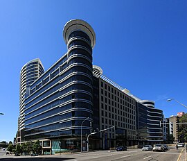
 The Forum | |||||||||||||||
| Population | 7,212 (SAL 2021)[1] | ||||||||||||||
| • Density | 9,015/km2 (23,350/sq mi) | ||||||||||||||
| Established | 1853 | ||||||||||||||
| Postcode(s) | 2065 | ||||||||||||||
| Elevation | 101 m (331 ft) | ||||||||||||||
| Area | 0.8 km2 (0.3 sq mi) | ||||||||||||||
| Location | 5 km (3 mi) north of Sydney CBD | ||||||||||||||
| LGA(s) | |||||||||||||||
| State electorate(s) | |||||||||||||||
| Federal division(s) | North Sydney | ||||||||||||||
| |||||||||||||||
St Leonards is a suburb on the lower North Shore of Sydney, Australia. St Leonards is located 5 km (3.1 mi) north-west of the Sydney central business district and lies across the local government areas of Municipality of Lane Cove, North Sydney Council and the City of Willoughby.
History
St Leonards was named after English statesman Viscount Sydney of St Leonards. Originally, St Leonards applied to the whole area from the present suburb of North Sydney to Gore Hill. The township of St Leonards in 1883 is now North Sydney.
St Leonards railway station is the oldest railway station on the North Shore railway line opening in 1890.[2][3]
Gore Hill Cemetery was established on the Pacific Highway in 1868 and was the main burial site for the area until its closure in 1975. It is still maintained as a heritage site by the Department of Local Government and Lands, Willoughby Municipal Council and the Heritage Council of New South Wales.
Heritage listings
St Leonards has a number of heritage-listed sites, including:
- Pacific Highway: Gore Hill Cemetery[4]
Population
In the 2016 Census, there were 5,495 people in St Leonards. 34.7% of people were born in Australia. The next most common countries of birth were China 8.6%, India 6.0%, Japan 4.5%, Hong Kong 4.4% and England 3.8%. 45.7% of people spoke only English at home. Other languages spoken at home included Mandarin 10.3%, Cantonese 7.7%, Japanese 4.7%, Hindi 3.1% and Korean 2.3%. The most common responses for religion were No Religion 40.3% and Catholic 16.2%.[5]
Commercial area


St Leonards has a commercial centre that complements the role of Chatswood, Lane Cove and North Sydney as one of the centres for business on the North Shore of Sydney. Until the 2010s, St Leonards contained one of Sydney's suburban skyscraper clusters, with major offices for large companies including CIMIC Group, IBM, Lenovo, Manchester Unity, Oporto, Savvytel, Toyota Australia, 2UE, 3 and Channel 31. Fox Sports studios are located at the Gore Hill end. Ichijo Homes had its headquarters in St Leonards in 2010, but moved to Kings Park in May 2011.
The Forum

The Forum is built over the railway station and comprises three commercial office buildings, two residential towers containing 782 apartments, an independent mini-supermarket, and 34 food and retail shops.[6]
Forum Tower (118m/38 stories) was the suburb's first high-rise apartment building complex completed in August 1999 and Forum West 3 three years later. Both buildings boast a concierge, pool, spa, gym and private & public car parking facilities each. Winten Property Group was responsible for the construction of both Forum buildings.
The Plaza also contains offices for Cisco, Verizon Business, Getty Images among other companies.
Transport
St Leonards railway station is on the North Shore railway line of the Sydney Trains network. The Pacific Highway is the major road through the suburb. Bus services through St Leonards are operated by Busways, CDC NSW, Keolis Downer Northern Beaches, Transdev John Holland and Transit Systems.[7]
Health

A major landuse in the suburb is the Royal North Shore Hospital which is the largest hospitals in Sydney.
Schools and churches
- A campus of the University of Technology, Sydney
- The campus of Northern Sydney TAFE
- Northside Community Church
- Royal North Shore Hospital Chapel[8]
Sport and recreation
St Leonards has developed into somewhat of a home for rugby union with the former headquarters of the Australian Rugby Union located at St Leonards (2007-2018), from neighbouring North Sydney. The Northern Suburbs Rugby Club has its clubhouse in St Leonards, featuring the Cabana Bar and Lounge. It also has a popular Rock Climbing Facility for the climbing community.
Gore Hill Oval, located on the grounds of Royal North Shore Hospital, is a synthetic field for AFL & cricket, ½ basketball court, handball courts, perimeter walking track, 2 exercise equipment stations and a playground.[9] It is also the home ground of Australian rules football club, North Shore Bombers.
References
- ^ Australian Bureau of Statistics (28 June 2022). "St Leonards (NSW) (suburb and locality)". Australian Census 2021 QuickStats. Retrieved 28 June 2022.
- ^ The Book of Sydney Suburbs, Compiled by Frances Pollen, Angus & Robertson, 1990, ISBN 0-207-14495-8, p.237
- ^ De-industrialisation of St Leonards Australian Railway History issue 858 April 2009 pages 115-125
- ^ "Gore Hill Memorial Cemetery". New South Wales State Heritage Register. Department of Planning & Environment. H01491. Retrieved 18 May 2018.
 Text is licensed by State of New South Wales (Department of Planning and Environment) under CC BY 4.0 licence.
- ^ Australian Bureau of Statistics (27 June 2017). "St Leonards (NSW) (State Suburb)". 2016 Census QuickStats. Retrieved 18 August 2018.
 Material was copied from this source, which is available under a Creative Commons Attribution 4.0 International License.
- ^ Forum, St Leonards - Winten Property Group
- ^ St Leonards station Transport for NSW
- ^ Chaplains 'pressured' over Royal North Shore crosses, Mosman Daily 28 April 2009.
- ^ "Gore Hill Oval".
External links
- Willoughby City Council
- St Leonards - community profile

