
Burlingame, San Diego

Burlingame is a neighborhood in San Diego, California, bordered by North Park to the north and east, and by South Park to the south, and is located within the boundaries of the Greater North Park Community Planning Area.[1]
Burlingame is a historic district recognized by the City of San Diego for its Craftsman Bungalow, Tudor Revival, Mission Revival, Spanish Colonial Revival, Prairie School, Art Deco and California Ranch architectural styles as well as properties that are hybrids of several styles.[1]
Gallery
-
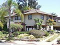 The Wegeforth-Wucher house, City of San Diego historical site no. 163
 -
 Plaque on the Wegeforth-Wucher house


References
32°43′54″N 117°7′36″W / 32.73167°N 117.12667°W
This San Diego County, California–related article is a stub. You can help Wikipedia by expanding it. |