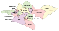
Tehran County
Appearance
Tehran County
شهرستان تهران | |
|---|---|
 Counties of Tehran Province | |
 Location of Tehran Province in Iran | |
| Coordinates: 35°41′N 51°24′E / 35.683°N 51.400°E | |
| Country | |
| Province | Tehran |
| Capital | Tehran |
| Bakhsh (Districts) | Central District, Kan District, Aftab District |
| Area | |
| • Total | 1,300.3 km2 (502.0 sq mi) |
| Population (2016)[1] | |
| • Total | 8,737,510 |
| • Density | 6,700/km2 (17,000/sq mi) |
| Time zone | UTC+3:30 (IRST) |
| • Summer (DST) | UTC+4:30 (IRDT) |
| Tehran County can be found at GEOnet Names Server, at this link, by opening the Advanced Search box, entering "9206102" in the "Unique Feature Id" form, and clicking on "Search Database". | |
| Year | Pop. | ±% |
|---|---|---|
| 2006 | 7,892,340 | — |
| 2011 | 8,189,791 | +3.8% |
| 2016 | 8,737,510 | +6.7% |
| amar.org.ir Excluding areas part of the county during previous censuses | ||
Tehran County (Template:Lang-fa) is a county in Tehran Province in Iran. The capital of the county is Tehran. At the 2006 census, the county's population was 7,882,843, in 2,313,002 families.[2] The county is subdivided into three districts: the Central District, Kan District, and Aftab District. The county has one city: Tehran.
Greater Tehran is situated mostly in Tehran County. It is the most populous county in Iran.
Divisions
Template:Tehran County divisions
References
- ^ "National census 2016". amar.org.ir. Retrieved 2017-03-14.
- ^ "Census of the Islamic Republic of Iran, 1385 (2006)" (Excel). Statistical Center of Iran. Archived from the original on 2011-09-20.
- اطلس گیتاشناسی استانهای ایران [Atlas Gitashenasi Ostanhai Iran] (Gitashenasi Province Atlas of Iran)

