Sunset Bay State Park
| Sunset Bay State Park | |
|---|---|
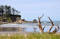
 View from the south end of the beach | |
| Type | Public, state |
| Nearest city | Coos Bay |
| Coordinates | 43°20′3.70″N 124°22′14.73″W / 43.3343611°N 124.3707583°W[1] |
| Area | 405 acres (164 ha)[2] |
| Created | 1948 |
| Operated by | Oregon Parks and Recreation Department |
| Visitors | Day-use: about 1.4 million annually. Overnight: about 70,000.[2] |
| Status | Open all year |

Sunset Bay State Park is a state park in the U.S. state of Oregon. Administered by the Oregon Parks and Recreation Department, it is about 0.4 miles (0.6 km) south of Cape Arago Lighthouse and 2.5 miles (4.0 km) outside the town of Charleston on Coos Bay. The park offers a crescent shaped beach, tide pools, hiking trails and a year-round campground.[3]
The park is one of three along the Cape Arago Highway, which runs along the Pacific Ocean west of U.S. Route 101. Sunset Bay State Park is about 1 mile (1.6 km) north of Shore Acres State Park and about 2 miles (3 km) north of Cape Arago State Park.[4] A hiking trail links Sunset Bay to Shore Acres.[5]
Land for the park was acquired in stages through 1984. Coos County donated the original tract to the state in 1948. In 1954, Ralph Barker donated a parcel with a water supply. The Bureau of Land Management later added tracts through a grant to the state, which also bought, exchanged, or otherwise acquired land from private owners. The combined size of the parcels is about 405 acres (164 ha).[2]
Sunset Bay is home to one of Oregon's ghost forests, created by an earthquake on the Cascadia subduction zone that dropped the shoreline about 1,200 years ago. The shoreline contains stumps of drowned spruce trees.
See also
References
- ^ "Sunset Bay State Park". Geographic Names Information System. United States Geological Survey, United States Department of the Interior. Retrieved June 6, 2011.
- ^ a b c "Park History". Oregon Parks and Recreation Department. Retrieved May 15, 2016.
- ^ "Sunset Bay State Park". Oregon State Parks and Recreation. Retrieved October 17, 2012.
- ^ "Shore Acres State Park" (PDF). Oregon Parks and Recreation Department. Retrieved May 15, 2016.
- ^ "Sunset Bay" (PDF). Oregon Parks and Recreation Department. Retrieved May 15, 2016.
External links

