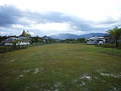
Pa Umor
Appearance
Pa Umor | |
|---|---|
 Pa Umor, May 2006 | |
| Coordinates: 3°44′00″N 115°31′00″E / 3.73333°N 115.51667°E | |
| Country | |
| State | |
| Administrative Division | Miri Division |
| Elevation | 862 m (2,828 ft) |
Pa Umor is a settlement in the Marudi division of Sarawak, Malaysia.[1][2] It lies approximately 623.9 kilometres (388 mi) east-north-east of the state's capital, Kuching.
The village lies about an hour’s walk east of Bario, and is only a few kilometres from the Indonesian border. There is a salt spring close to Pa Umor, significant because, without a local source of salt, inhabitants would have to travel to the coast for it.[3]
In 2007 the village population was made up of about forty Kelabit families.[4]
Neighbouring settlements include:
- Bario 7.6 kilometres (4.7 mi) west
- Pa Lungan 7.6 kilometres (4.7 mi) north
- Pa Main 11.1 kilometres (6.9 mi) south
- Pa Mada 15 kilometres (9.3 mi) south
- Pa Bangar 15.3 kilometres (9.5 mi) south
- Long Semirang 15.8 kilometres (9.8 mi) west
- Long Rapung 15.8 kilometres (9.8 mi) north
- Long Danau 18.6 kilometres (11.6 mi) south
- Pa Dali 20.7 kilometres (12.9 mi) south
- Ramudu Hulu 20.7 kilometres (12.9 mi) south
References
- ^ M. Mohizah, S. Julia and W. K. Soh (2006). A Sarawak Gazetteer (PDF). Kuala Lumpur: Sarawak Forestry Department Malaysia and Forest Research Institute Malaysia. ISBN 983-2181-86-0. OCLC 85818866. Archived from the original (PDF) on 2011-07-22. Retrieved 2011-01-01.
- ^ "Pa Umor, Malaysia". Geonames. 1994-02-10. Retrieved 2010-12-27.
- ^ James Alexander (1 December 2006). Malaysia Brunei & Singapore. New Holland Publishers. pp. 354–. ISBN 978-1-86011-309-3. Retrieved 28 January 2011.
- ^ Wilhelmina Cluny & Dr. Paul Chai P.K. (2007-09-17). "Cultural sites of the Northern Highlands – Megaliths and Burial Sites" (PDF). International Tropical Timber Organization & Forest Department Sarawak. Retrieved 2011-01-28.[permanent dead link]

