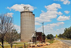
Dingo, Queensland
| Dingo Queensland | |||||||||||||||
|---|---|---|---|---|---|---|---|---|---|---|---|---|---|---|---|
 Grain silos at Dingo, 2017 | |||||||||||||||
| Coordinates | 23°39′0″S 149°20′0″E / 23.65000°S 149.33333°E | ||||||||||||||
| Population | 342 (2011 census)[1] | ||||||||||||||
| Postcode(s) | 4702 | ||||||||||||||
| Location |
| ||||||||||||||
| LGA(s) | Central Highlands Region | ||||||||||||||
| State electorate(s) | Gregory | ||||||||||||||
| Federal division(s) | Flynn | ||||||||||||||
| |||||||||||||||
Dingo is a town and locality in the Central Highlands Region in Queensland, Australia.[2][3]
Geography
The town is on the Capricorn Highway, 762 kilometres (473 mi) north west of the state capital Brisbane and 148 kilometres (92 mi) west of the regional centre of Rockhampton. The Fitzroy Developmental Road runs north-west from the Capricorn Highway.[4]
History
The town was surveyed in 1889 and took its name from the nearby Dingo Creek.[3] For a time in 1940 the town was known as Remo.[3] Dingo Post Office opened on 1 October 1876.[5]
Dingo State School opened on 29 May 1876.[6]
In 1973, a population of Bridled nail-tail wallabies (Onychogalea fraenata) was found in the Dingo area by a fencing contractor. Until this sighting the species was thought to be extinct having not been seen since 1937. The area where the wallabies was rediscovered was protected as Taunton National Park.[7]
In the 2006 census, Dingo had a population of 263 people.[8]
In the 2011 census, Dingo had a population of 342 people.[1]
Amenities
The Central Highlands Regional Council operates a public library at Normanby Street.[9]
Notable residents
Australian rugby league player Ben Hunt grew up in Dingo.
External links
References
- ^ a b Australian Bureau of Statistics (31 October 2012). "Dingo". 2011 Census QuickStats. Retrieved 11 October 2015.
- ^ "Dingo – town (entry 9993)". Queensland Place Names. Queensland Government. Retrieved 11 October 2015.
- ^ a b c "Dingo – locality (entry 46946)". Queensland Place Names. Queensland Government. Retrieved 11 October 2015.
- ^ "Dingo, Queensland" (Map). Google Maps. Retrieved 13 August 2019.
- ^ Premier Postal History. "Post Office List". Premier Postal Auctions. Retrieved 10 May 2014.
- ^ "Opening and closing dates of Queensland Schools". Queensland Government. Retrieved 18 April 2019.
- ^ "Bridled nailtail wallaby". Department of Environment and Resource Management (Queensland). Archived from the original on 11 May 2012. Retrieved 24 April 2012.
- ^ Australian Bureau of Statistics (25 October 2007). "Dingo". 2006 Census QuickStats. Retrieved 11 October 2015.
- ^ "Dingo Library". Public Libraries Connect. State Library of Queensland. 28 November 2016. Retrieved 29 January 2018.

