
Whitchurch railway station (Wales)
Whitchurch (Cardiff) | |
|---|---|
| General information | |
| Other names | Welsh: Yr Eglwys Newydd |
| Location | Cardiff |
| Coordinates | 51°31′15″N 3°13′20″W / 51.5208°N 3.2222°W |
| Managed by | Transport for Wales |
| Platforms | 1 |
| Other information | |
| Station code | WHT |
| History | |
| Original company | Cardiff Railway |
| Pre-grouping | Cardiff Railway |
| Post-grouping | Great Western Railway |
| Key dates | |
| 1 March 1911 | Opened as Whitchurch |
| 1 July 1924 | Renamed Whitchurch (Glam) |
| 5 May 1975 | Renamed Whitchurch (South Glam) |
| ? | Renamed Whitchurch (Cardiff) |
Whitchurch railway station is a railway station serving Whitchurch, Cardiff, Wales. It is located on the Coryton Line 4.5 miles (7.2 km) north of Cardiff Central and is situated beneath the A470 road.
Passenger services are provided by Transport for Wales as part of the Valley Lines network.
History
It was opened by the Cardiff Railway in 1911. Until the 1960s Whitchurch station had 2 platforms (up and down lines) plus a goods platform, a goods shed and yard, booking office, footbridge, and a staff of at least 2 including George the porter. There was also a signal box at the eastern end of the platform [1]
Service
Monday to Saturday daytimes, there is a half-hourly service to southbound Cardiff Central and onwards to Radyr on the City Line and to Coryton northbound. Evenings there is an hourly service in each direction but there is no Sunday service.[2]
| Preceding station | Following station | |||
|---|---|---|---|---|
| Rhiwbina | Transport for Wales Coryton - Cardiff Queen Street - Radyr |
Coryton | ||
Gallery
-
 Station entrance from A470, 2013
 -
 Steps to station from A470, 2013
 -
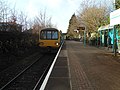 The station looking towards Coryton, 2013
 -
 The station looking towards Cardiff, 2013
 -
 Looking down the line to Coryton from the station, 2013
 -
 The station from the A470 roadbridge, 2013


See also
References
- ^ Whitchurch Station
- ^ Table 130 National Rail timetable, May 2016
External links
- Train times and station information for Whitchurch railway station (Wales) from National Rail
| Valley lines | |
|---|---|
| Other lines | |
| Major stations | |
| Cardiff stations | |
| Newport stations | |
| Valley Lines stations |
|
| Other stations | |
| Proposed stations | |
| Motorways and A roads |  | |
|---|---|---|
| Pedestrian precincts and commercial streets | ||
| Bus | ||
| Cycling | ||
| Railway lines | ||
| Railway operators | ||
| Major railway stations | ||
| Other city railway stations | ||
| Air | ||
| Water | ||
| Proposed transport network |
| |
This Wales railway station-related article is a stub. You can help Wikipedia by expanding it. |