Njeru
Njeru | |
|---|---|
| Coordinates: 0°25′52″N 33°08′52″E / 0.43111°N 33.14778°E | |
| Country | |
| Region | Central Region |
| District | Buikwe District |
| County | Buikwe County |
| Constituency | Buikwe North |
| Government | |
| • Member of Parliament | Kakoba Onyango |
| Elevation | 1,100 m (3,600 ft) |
| Population (2014 Census) | |
| • Total | 159,549[1] |
| Time zone | UTC+3 (EAT) |
Njeru is a town in Buikwe District, Central Region of Uganda. It is the largest town in the district. It is mainly a residential town. It hosts industries such as Nyanza Textiles Limited(Nytil), a textiles manufacturer, Nile breweries limited, East African packaging limited.
The town offers stunning views of River Nile both the source and further downstream as well as hosting the annual Nyege Nyege festival.
Location
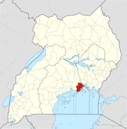
Njeru is located approximately 32 kilometres (20 mi) northeast of Buikwe, where the district headquarters are located.[2] This location lies about 10 kilometres (6.2 mi) west of downtown Jinja.[3] The town is located across River Nile from the city of Jinja and is functionally a suburb of that city. The coordinate of Njeru Town Council are:0°25'52.0"N, 33°08'52.0"E (Latitude:0.431111; Longitude:33.147778).[4]
Economic activity
This section needs additional citations for verification. (May 2016) |
There are several industries and businesses located in Njeru that provide employment to a significant number of people and contribute significantly to the economy of Uganda. These include but are not limited to:
- Nile Breweries Limited - A subsidiary of SAB Miller, based in South Africa
- Nalubaale Power Station - Installed Capacity 180 MW - Operated by Eskom (Uganda), a subsidiary of Eskom
- East African Packaging Solutions - A 50/50 Joint Venture between the Madhvani Group and Graphic Systems Limited.[5]
- Nytil Picfare - The biggest garments factory in Uganda, making garments out of locally grown organic cotton.
- Nile Vocational Institute - A Technical College with over 100 Students founded by German Charity Kindernothilfe
- Vitafoam Industries - A Factory Manufacturing Mattresses.
- Njeru Stock Farm - Formerly a government Livestock Farm, now Used as an Army Detach.
Transportation
Both the old Kampala-Jinja Highway and the new Kampala–Jinja Expressway, pass through Njeru and are part of the northern corridor of the Trans-Africa Highway. The Kampala–Jinja Expressway connects to the New Jinja Bridge in Njeru.
Population
The population of Njeru, according to the 2002 national census was 51,236. In 2010, the Uganda Bureau of Statistics (UBOS), estimated the population of the town at 63,200. In 2011, UBOS estimated the mid-year population of Njeru at 64,900.[6] In 2014, the national population census put the population of Njeru at 159,549.
See also
References
- ^ UBOS, . (27 August 2014). "The Population of The Regions of the Republic of Uganda And All Cities And Towns of More Than 15,000 Inhabitants". Citypopulation.de Quoting Uganda Bureau of Statistics (UBOS). Retrieved 23 February 2015.
{{cite web}}:|first=has numeric name (help) - ^ "Road Distance Between Buikwe And Njeru With Map". Globefeed.com. Retrieved 21 January 2015.
- ^ "Map Showing Njeru And Jinja With Interactive Route Marker". Globefeed.com. Retrieved 21 January 2015.
- ^ Google (2 July 2015). "Location of Njeru Town At Google Maps" (Map). Google Maps. Google. Retrieved 2 July 2015.
- ^ "Madhvani Group: Packaging - East African Packaging Solutions Limited". Kakira Sugar Works. Retrieved 21 January 2015.
- ^ UBOS, . (2011). "Estimated Population of Njeru In 2002, 2010 And 2011" (PDF). Uganda Bureau of Statistics (UBOS). Archived from the original (PDF) on 2013-01-19. Retrieved 21 January 2015.
{{cite web}}:|first=has numeric name (help)


