Pico do Areeiro
Appearance
| Pico do Arieiro | |
|---|---|
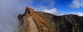
 View of Pico Do Arieiro from the west | |
| Highest point | |
| Elevation | 1,818 m (5,965 ft)[1] |
| Coordinates | 32°44′08″N 16°55′44″W / 32.73556°N 16.92889°W |
| Geography | |
| Location | Madeira |
Pico do Arieiro, at 1,818 m (5,965 ft) high, is Madeira Island's third highest peak.[2] Most days, visitors can stand and look down on the clouds. The air is fresh and clear and the sun is very bright. On a clear day it is possible to see the neighbouring island of Porto Santo, 30 miles to the northeast.
The footpath northwards towards Pico Ruivo is an important tourist attraction, with a daily average of 1000 tourists trekking on it.
There is easy road access to the summit, with a large car park, a restaurant and souvenir shop. In 2011, an Air Defence Radar Station was built at the top of the mountain near the tourist facilities.
References
- ^ Pico do Arieiro at peakbagger.com
- ^ Madeira Geography Archived 2011-07-14 at the Wayback Machine
External links
![]() Media related to Pico do Areeiro at Wikimedia Commons
Media related to Pico do Areeiro at Wikimedia Commons


